Please accept this as Second Referral comments from Community Planning regarding the aforementioned application.
|
|
|
- Emma Houston
- 5 years ago
- Views:
Transcription
1 Hancock, Richard From: Sent: To: Cc: Subject: Carter, Joseph Friday, July 15, :08 PM Hancock, Richard Barker, Ricky W.; Garcia, Christopher Community Planning 2nd Referral Comments SIDP Westmoore Sign Development Plan Rick, Please accept this as Second Referral comments from Community Planning regarding the aforementioned application. The application retains the unified and coordinated design and color theme presented in the first submission package. The application has been revised to address the majority of comments regarding the number, size, and setback from right of way. It is noted that Old Ryan Road has not been widened to the full right of way that was provided as part of the Westmoore development site; therefore, the setbacks proposed for sign 9 may be appropriate given this sign is a temporary. Community Planning staff recommends the following comments be addressed: Revise the number of Sign 9 from 9 to 6. Staff was unable to locate the other 3 signs. Add note that only Sign 9 will be located along Old Ryan Road. Add note that temporary signs proposed in same location as permanent signs shall be removed upon construction of permanent sign. Response letter stated it was added but staff could not locate. Relocate Sign 7 in A1 detail 2 away from Old Ryan Road. As positioned, the sign is serving as general advertisement sign for the builder and should be located internal to the project site. Relocate Sign 8 in A1 detail 2 closer to the entrance to parking area for models. Relocate Sign 7 in A1 detail 3 away from Old Ryan Road. As positioned, the sign is serving as advertisement sign for the builder and should be located internal to the project site. Staff suggests relocating the sign internal to the site near the parking area for the models. Thank you. Joseph Carter, AICP, CZA, GISP Senior Planner, Community Planning Division LOUDOUN COUNTY DEPARTMENT OF PLANNING & ZONING 1 Harrison Street, S.E. 3rd Floor, Mail Stop #62 Leesburg, VA Direct: (703) Visit us on the web at: This is not intended to be and shall not be deemed to be an official order, requirement, decision or determination made by or on behalf of the Zoning Administrator. In keeping with the Virginia Freedom of Information Act (FOIA), s and all attachments may be released to others upon request for inspection and copying without prior notification. 1 Attachment 1

2 County of Loudoun Department of Planning MEMORANDUM DATE: March 21, 2016 TO: FROM: Rick Hancock, Project Manager Land Use Review Joseph Carter, AICP, CZA, GISP, Senior Planner Community Planning SUBJECT: SIDP , Westmoore Sign Development Plan BACKGROUND The applicant, NVR, Inc., has submitted a Sign Development Plan (SIDP) to the County to modify the sign provisions of the Revised 1993 Zoning Ordinance for a portion of the Moorefield Station development. No changes are proposed to permanent signage approved by the Board of Supervisors on March 13, 2013 via ZMOD The applicant seeks to modify the short-term signage provisions for a 65.3-acre portion of the Moorefield Station development, known as Westmoore (see vicinity map). Westmoore is approved for up to 599 single family attached residential dwelling units (townhouses). The site is located within the Ashburn community of the Suburban Policy Area within a mile of the planned location of the Ashburn Metro Station. In general, the application requests to: Increase the maximum aggregate sign size for signs labeled T-1, T-2, T-3, T-4, and T-15. Increase the maximum area permitted of any individual sign labeled T-1, T-2, T-3, T- 4, T-5, T-6, T-8, T-9, T-15, T- 25, T-26, and T-27. Increase the maximum height of signs labeled T-1, T-2, T-7, T-8, T-9, T-25, and T-26. VICINITY MAP
3 SIDP , Westmoore Sign Development Plan Community Planning First Referral March 21, 2016 Page 2 ANALYSIS DESIGN The application proposes a unified and coordinated design theme that establishes the color palette, typology, and logos for a majority of the signage, excluding a few located internally to the subdivision. Overall, the sign development package presents a coordinated, attractive, and high-quality design theme. ILLUMINATION County policies call for appropriate lighting to achieve the following: o Promote the use of lighting for convenience and safety without the nuisance associated with light pollution; o Promote a glare-free environment through proper lighting performance standards to improve visibility and enhance public safety; o Promote appropriate lighting standards to conserve energy; and, o Develop appropriate lighting standards to prohibit unnecessary and intrusive light trespass that detracts from the beauty and view of the night sky (Revised General Plan, Chapter 5, Lighting and Night Sky Policies, Policy 1). There are discrepancies within the application regarding whether illumination is proposed for the signage. These discrepancies should be reconciled in conformance with County s lighting policies. COMPATIBILITY The signage matrix comparing the proposed signage with that permitted by the Zoning Ordinance excludes the total number of signs proposed for each category. Instead, the matrix lists the maximum number as permitted per the Zoning Ordinance, i.e. 1 per vehicle entrance. The maximum number of signs for each sign type should be identified in order to determine the exact number of signs proposed. There also appears to be inaccuracies with the application s labeling of signage types, i.e. off-site vs. on-site signs; however, Community Planning staff defers to Zoning Administration staff to determine if the signage types are listed correctly within the matrix. The modifications requested to the permitted sign dimensions are highlighted in yellow below: Sign Label Sign Type T-1 Community Welcome on site; Ordinance Maximum (Sq. ft. & height) 4 sq.ft. & 4 ft. tall Sign Modifications Proposed Sign Area Maximum 50 sq.ft. & 8 ft. tall Comment Approximately 12 times the maximum size and approximately twice the maximum height permitted by the ordinance. The content of sign appears to be predominantly advertising rather than a Community Welcome sign. Located at approved locations for permanent signage and should be removed upon construction of permanent signage approved with ZMOD
4 SIDP , Westmoore Sign Development Plan Community Planning First Referral March 21, 2016 Page 3 T-2 Community - Future of T-3 Construction Fencing T-7 Community Welcome on site; T-8 Welcome Center T-9 Community Lifestyle T-15 Construction Rules T-25 Model Home Builder Information T-26 Builder Directional 4 sq.ft. & 4 ft. tall 4 sq.ft. & 5 ft. tall 4 sq.ft. & 4 ft. tall 4 sq.ft. & 4 ft. tall 4 sq.ft. & 4 ft. tall 10 sq.ft. & 8 ft. tall 20 sq.ft. & 6 ft. tall 2 sq.ft. & 4 ft. tall 48 sq.ft. & 9 ft. tall 300 sq.ft. & 5 ft. tall 50 sq.ft. & 8 ft. tall 15 sq.ft. & 9 ft. tall sq.ft. & 13 ft. tall 32 sq.ft. & 8 ft. tall 24 sq.ft. & 7 ft. tall 15 sq.ft. & 6 ft. tall Approximately 12 times the maximum size and approximately twice the maximum height permitted by the ordinance. Greatly exceeds the maximum sign area permitted (approximately 75 times) by the ordinance. It is assumed that the signage will be moved with the fencing throughout the project site. Typically, the purpose of the mesh is to screen construction activities from view and/or to aid the prevention of dust/dirt movement during construction activities. Approximately 12 times the maximum size and approximately twice the maximum height permitted by the ordinance. The location of signs are not identified on the plan. Approximately 4 times the maximum size and approximately twice the maximum height permitted by the ordinance. Appears to be general advertising signage rather than informational for motorist, bicyclist and/or pedestrians and would be more appropriately located in the model home. Approximately 6 times the maximum size and approximately 3 times the maximum height permitted by the ordinance. The location of signs are not identified on the plan. Appears to be general advertising signage rather than informational for motorist, bicyclist and/or pedestrians and would be more appropriately located in the model home. Approximately 3 times the size permitted by the ordinance. However, given the nature of the signage the size can be justified if located internally to the project site. Moderate increase in size and height. 6 ft. height is appropriate scale for motorists. Appears to be larger to identify each builder. Approximately 8 times the size permitted by the ordinance. Located at approved locations for permanent signage and should be removed upon construction of permanent signage approved with ZMOD Community Planning staff notes the following general observations of the sign development plan: Only signs T-1 (Community Welcome), T-25 (Model Home Builder Information) and T-26 (Builder Directional) are located along public roadways Old Ryan Road (Route 772) and Mooreview Parkway (Route 2298). Sign T-25 is not appropriate along
5 SIDP , Westmoore Sign Development Plan Community Planning First Referral March 21, 2016 Page 4 these roadways as T-25 conveys a sense of arrival to the model rather than provide directions like signs T-1 and T-26. Signage along these roadways should be limited to T-1 and T-26. Several signs appear to duplicate information of other signage: o Sign T-7 duplicates sign T-1; o Signs T-4 and T-5 duplicate the individual builders listed on Sign T-6 separately. o Signs T-11 and T-12 duplicate the individual builders listed on Sign T-13 separately; o Signs T-21 and T-22 duplicate the individual builders listed on Sign T-23 separately; and o Two T-25 signs are located at the Croson Model Park. Signs T-4, T-5, T-6 (A-Frame Signs), and T-27 (Builder Model Parking) propose a minor modification to sign size (no more than 2 square feet). Signs T-10 through T-24 and T-27 are signs typically found as short-term signage for subdivision building sites in Loudoun. Other than signs T-15 and T-27, no modifications are proposed. The sign plan should specify the location of signs T-10 through T-24, and T-27. Signage proposed to greatly increase in height or sign area should be setback further than the Zoning Ordinance minimum to avoid the potential of visual clutter along roadways, especially along public roadways Old Ryan Road (Route 772) and Mooreview Parkway (Route 2298). RECOMMENDATIONS Although the application is for short-term signage, the proposed signs far exceed the amount permitted in the Zoning Ordinance, provide repetitive information, and create the potential for visual clutter, which may detract from the overall quality of the development. Overall, the sign development package presents a coordinated, attractive, and high-quality, thematic design. Certain aspects of the signage proposed, as noted above, presents visual clutter and repetitive information. Community Planning Staff recommends the following: Provide a maximum number for all signs proposed. Identify the location for all signs proposed. Clarify whether signs will be illuminated and if so, detail lighting as full cutoff, fully shielded, downward directed, and demonstrate energy efficient measures. Remove Signs T-4, T-5, T-7, T-11, T-12, T-21, and T-22. These signs provide redundant information and create the potential for visual clutter. The residual signs (T-1, T-6, T-13, and T-23) serve the purpose of each of these signs removed and will maintain a unified and coordinated design with other signage in the development. Remove any signage that serves as general advertisement from view of Old Ryan Road and Mooreview Parkway. Add a note that signs T-1 and T-26 will be removed when the permanent signage for each location is installed.
6 SIDP , Westmoore Sign Development Plan Community Planning First Referral March 21, 2016 Page 5 Add a note to state that no signs, other than T-26 will be located along Old Ryan Road and Moorefield Parkway. Remove note on Sheet 11 and specifically identify where such signs can be located per the description of respective signage. Reduce the sign height of Sign T-25 (Model Home Builder Information) to no more than 6 feet or increase setback distance from right-of-way. Increase setbacks for signs T-1, T-2, T-3, T-7, T-8, T-9, and T-25 commensurate with the respective increase for sign dimensions or height. Revise the proposed location of sign T-2 (Community - Future Site Of) to only sites of future development amenities to achieve its purpose rather than 1 per vehicular entrance. Remove the T-25 (Model Home Builder Information) sign from intersection of Old Ryan Road and Croson Lane. Sign T-8 (Welcome Center onsite) and the second T-25 sign serve the purpose of identifying the location of the Croson Model Park to motorists. Sign type T- 26 (Builder Directional) appears to be more appropriate for this location and could serve the purpose of the adjacent T-26 sign in the southeast corner of the intersection of Old Ryan Road and Croson Lane. Staff is available to meet with the applicant to discuss these issues. cc: Ricky Barker, AICP, Director (via ) Chris Garcia, AICP, Assoc. AIA, LEED-GA, Program Manager (via )
7 COUNTY OF LOUDOUN SIDP , Westmoore Sign Development Plan 2 nd Referral Comments August 10, 2016 Page 1 DEPARTMENT OF PLANNING AND ZONING ZONING ADMINISTRATION REFERRAL DATE: August 10, 2016 TO: FROM: CC: Rick Hancock, Project Manager, Land Use Review Kate A. McConnell, AICP, Senior Planner, Zoning Administration Chris Mohn, Deputy Zoning Administrator CASE NUMBER & NAME: SIDP , Westmoore Sign Development Plan, 2 nd Referral Tax Map # PIN Tax Map # PIN Tax Map # PIN /93//20////E2/ /78/P/1/////B/ /93/D1/////68/ /93//19/////B/ /92/C/4/////2/ /93/D/1////71/ /93//19/////C/ /93//19/////A/ /93/D/1///6000/ /78/P/1/////A/ /93/D/1////A The Applicant is requesting approval of a sign development plan (SIDP) under (E) of the Revised 1993 Zoning Ordinance (Zoning Ordinance). Staff reviewed the referenced SIDP application dated June 28, 2016 and prepared by Land Planning & Design Associates (LPDA). Technical Comments Cover Page 1. Please include the application number, SIDP , on the cover page. Conditions of Approval 2. If Conditions of Approval are imposed as part of the approval for this SIDP, then please include the Conditions of Approval after the Table of Contents in the sign plan. Also, please include the Conditions in the Table of Contents and revise the date of the sign plan as it relates to the final date of the Conditions of Approval, e.g. the sign plan date should be the same or later than the date of the Conditions of Approval. Statement of Justification (Page 4) 3. Under the Section (E)(1) criteria, please revise criterion e by removing the word and prior to the statement, Lighting is not proposed. General Sign Specifications (Page 8) 4. Please remove General Note 11, as the note references signs that are not part of this SIDP application and the previously approved signs are referenced in Note 10. Furthermore, new signs may be included in later sign plans or in accordance with Section of the Zoning Attachment 1b
8 SIDP , Westmoore Sign Development Plan 2 nd Referral Comments August 10, 2016 Page 2 Ordinance in addition to those approved with ZMAP /ZCPA Please revise General Note 12 to state, Only one model park shall be open at a time. Upon closing of the Croson Model Park, all Croson Model Park signs will be removed and the Southland Model Park will be opened and Southland Model Park signs permitted and installed. In addition, please note that specific parcels have been identified in the SIDP for the model park signs. Therefore, if a model location is changed as mentioned in Note 2, the sign or signs must still be placed on the parcel or parcels identified in the SIDP. 6. Please remove General Note 13, as General Note 10 more clearly states that signs not included in the SIDP will be permitted provided they conform to the Zoning Ordinance. Signs (Pages 10-20) Community Future Site Of Signs: Please confirm the reference to the Westmoore logo, which appears to be an M, not a W, as stated in the Notes Community Fence Wrap Signs: Please delete the word, suggested from the Description. Please confirm the reference to the Westmoore logo, which appears to be an M, not a W, as stated in the Notes Westmoore A-Frame Signs: Since the proposed signs are not affixed to the ground, please further clarify when the A-Frame signs will be placed near the model homes in the Notes. It is unclear whether the signs will be displayed at all times or only when the model homes are open for the public to visit, as the same timeframe is provided for the Welcome Center Signs which appear to be ground-mounted. Additionally, please refer to General Note 12 on Page 8 in the Notes, as it provides additional information about the length of time the sign is permitted to be in place. Please revise the corresponding Signage Matrix Note on Page 22 accordingly Welcome Center Signs: Please revise the Total Aggregate Sign Area to include two faces of the proposed sign. As defined in Article 8 of the Zoning Ordinance, the area of a back to back sign only includes one face of the sign. Since the proposed sign is a quad faced sign, two faces of the sign must be included in the area calculation. Please also resolve this discrepancy in the Signage Matrix (Page 22). Additionally, please refer to General Note 12 on Page 8 in the Notes, as it provides additional information about the length of time the sign is permitted to be in place. Please revise the corresponding Signage Matrix Note on Page 22 accordingly Construction Rules Sign: The Notes state this sign will be placed at construction entrances; however, the total number of signs is one (1). Please correct this discrepancy. Additionally, please further clarify the intent of this note, as it is unclear where the signs will be moved as each phase closes out. Please make a similar revision to the corresponding section of the Signage Matrix on Page Builder Directional Signs: Please revise the Notes to state that the signs will be located as shown on the maps in Appendix A, A1, and/or A2, rather than stating they may be placed throughout the community.
9 Signage Matrix (Pages 21-24) SIDP , Westmoore Sign Development Plan 2 nd Referral Comments August 10, 2016 Page Please remove the word, Proposed from the Westmoore Sign Criteria column headings, as this SIDP will be the regulating document for the signs in Westmoore if approved and, therefore, would not be proposed. 14. Please clarify the intent of the statement, *All signs located per plan at the bottom of pages There is no asterisk in the table that relates to the asterisk in the note. Also, if the intent is to reference the maps included in the Appendices, please reference as such Community Future Site Of Signs: Please revise the Note to include an enforceable time for sign removal, e.g. issuance of the occupancy permit for the amenity, rather than the opening of the amenity, which is vague Community Fence Wrap Signs: In the Type description for the proposed sign, please include that the Banner will be affixed to a fence. Please similarly revise Page 13 with regard to sign type. Additionally, please revise the Note to include an enforceable time for sign removal, e.g. issuance of the occupancy permit for the amenity, rather than the opening of the amenity, which is vague Construction Rules Sign: Please state in the note that the signs will be removed prior to issuance of the final occupancy permit for the residential development Builder/Realtor For Sale Signs: The maximum number of signs permitted is one per lot less than 10 acres in size. Therefore, each lot that would be for sale in this residential development is permitted one 6-square-foot, freestanding, for sale sign. Please revise the Proposed Westmoore Sign Criteria based on the method signs are permitted, as well as Signage description on Page 17, stating in the Max. Number of Signs category that one sign is permitted per lot less than 10 acres in size Builder Directional Signs: According to the Article 8 definitions for on-site and off-site signs, signs within the Moorefield Station rezoning are on-site and signs outside the Moorefield Station rezoning are off-site. Currently, all directional signs are categorized in the Signage Matrix as off-site, but only one sign depicted on the Sign Location Map would be categorized as off-site the sign proposed in the PD-H3 Zoning District south of the property subject to the Moorefield Station rezoning. Please add an additional directional sign category for on-site signs and include the remaining northern four Builder Directional signs depicted on the Westmoore Sign Location Map in this category. Please revise the sign location map and signage description accordingly. Appendix A 20. Please clarify the note, All signs to be on private property as shown in the parcel identification table on page 6, as the sign locations are depicted on the sign location maps and cannot be shown on a list of parcel numbers. Appendix A1 21. Detail 2 Southland Model Park: The Parcel ID for sign 9 in the Sign Key is incorrect. Please provide the correct PIN. Also, please indicate that the location of sign 4 is also on the parcel identified as H.
10 SIDP , Westmoore Sign Development Plan 2 nd Referral Comments August 10, 2016 Page Detail 3 Croson Model Park: The Parcel ID for sign 7 in the Sign Key is not included in the list of parcels to be subject to SIDP on Page 6. Please correct this discrepancy. Also, there are two locations depicted in the detail map for sign 7, one of which is on Parcel ID , which is included in the list of parcels subject to the sign plan on Page 6. Appendix B 23. On the map of previously approved signs, please state that the Entrance and Future Amenity Signs are note part of the SIDP application, similar to the statement for ZMAP and ZMOD in the Sign Key. Issues for Consideration (pursuant to (E)(1)) a. Assist motorists, bicyclists and/or pedestrians in finding a location without difficulty or confusion; With the exception of the location of five proposed Directional Signs (Sign 9), which Zoning Staff cannot evaluate without more information (see Criterion f below), Zoning Staff finds the number and location of signs as proposed will assist motorists, bicyclists, and/or pedestrians in finding a location without difficulty or confusion. b. Clearly identify places of business or communities, while avoiding unnecessary redundancy; With the exception of the location of five proposed Directional Signs (Sign 9), which Zoning Staff cannot evaluate without more information(see Criterion f below), Zoning Staff finds the number and location of signs as proposed avoid unnecessary redundancy. c. Demonstrate compatibility with, and be subordinate to, the structures and land uses referenced by the sign; With the exception of five proposed Directional Signs (Sign 9), which Zoning Staff cannot evaluate without more information (see Criterion f below), Zoning Staff finds number and location, as well as the temporary nature of the proposed signs, are compatible with and subordinate to the structures and land uses referenced by the proposed signs. d. Address impacts to the night sky; The Applicant is not proposing lighting; therefore, there are no impacts to the night sky. e. Incorporate energy efficient measures, where possible; The Applicant is not proposing lighting; therefore, energy efficient measures are unnecessary. f. Provide a sufficient number of graphic messages or displays without creating competing demands for visual attention; Similar to the previous comment, Zoning Staff notes the Applicant provided a map depicting the location of permanent signs previously approved with ZMAP /ZCPA The five proposed Directional Signs (Sign 9) are proposed to be located in the same general location as previously approved entrance (permanent or impermanent) and future amenity signs. Please provide information showing the relationship between the proposed Directional Signs and previously approved entrance and future amenity signs to demonstrate the proposed placement will not create competing demands for visual
11 SIDP , Westmoore Sign Development Plan 2 nd Referral Comments August 10, 2016 Page 5 attention with the previously approved signs. Without this information, Zoning Staff cannot evaluate this criterion.
12 COUNTY OF LOUDOUN DEPARTMENT OF PLANNING AND ZONING ZONING ADMINISTRATION REFERRAL SIDP , Westmoore Sign Development Plan 1 ST Referral Comments March 8, 2016 Page 1 DATE: March 8, 2016 TO: FROM: CC: Rick Hancock, Project Manager, Land Use Review Kate A. McConnell, AICP, Planner, Zoning Administration Chris Mohn, Deputy Zoning Administrator CASE NUMBER & NAME: SIDP , Westmoore Sign Development Plan, 1 st Referral Tax Map # PIN Tax Map # PIN Tax Map # PIN /93//20////E2/ /78/P/1/////2/ /78/P/1/////6/ /93//19/////B/ /78/P/1/////3/ /78/P/1/////B/ /93//19/////C/ /78/P/1/////4/ /78/P/1/////8/ /78/P/1/////1/ /78/P/1/////5/ /92/C/4/////2/ /78/P/1/////A/ /78/P/1/////7/ /93//19/////A/ The Applicant is requesting approval of a sign development plan (SIDP) under (E) of the Zoning Ordinance. Staff reviewed the referenced SIDP application dated February 4, 2016 and prepared by Land Planning & Design Associates (LPDA). The bulk of the subject property is zoned Planned Development Transit Related Center (PD-TRC) as administered under the Revised 1993 Loudoun County Zoning Ordinance (Zoning Ordinance) and subject to the proffers and concept development plan approved with ZMAP and ZCPA , Moorefield Station. One off-site parcel is included in the application and zoned Planned Development - Housing 3 (PD-H3). The property is partially located in the Floodplain Overlay District (FOD) and Airport Impact Overlay District (AIOD) Ldn 60 1 mile buffer. Moderately steep slopes are also located on the property and subject to the additional development standards contained in of the Zoning Ordinance. General Comments 1. The applicant is advised that if inconsistencies are identified within the SIDP, the most restrictive provision will apply at time of zoning permit. Zoning Staff recommends the applicant carefully review the Sign Location Map, the Short Term Signage details/illustrations, and the Signage Matrix for inconsistencies, errors, and omissions. 2. According to the Article 8 definitions for on-site and off-site signs, signs within the Moorefield Station rezoning are on-site and signs outside the Moorefield Station rezoning are off-site. Currently, signs are categorized in the Signage Matrix as on-site or off-site, but only one sign depicted on the Sign Location Map would be categorized as off-site. Please ensure signs are categorized correctly, particularly when considering comment 4 below. 3. When addressing the Max. Number of Signs in the Short Term Signage details and the
13 SIDP , Westmoore Sign Development Plan 1 ST Referral Comments March 8, 2016 Page 2 Signage Matrix, please provide the number of signs proposed rather than copying the Max. Number of Sign standard. For example, instead of stating the maximum number of signs will be 1/vehicular entrance, provide the number of signs proposed based on vehicular entrances or modify the standard as needed. Similarly, if commercial signs are not proposed, then remove any size or location requirements related to such signs. Additionally, provide the location of each sign on the Sign Location Map. 4. Modifying the Article 8 sign definitions and the Sign Category in Table (D) are not permitted as part of an SIDP application. Therefore, the Temporary Sign On-Site and Temporary Signs Off-site categories may not be used for signs that do not meet the Article 8 Definition of Temporary Signs. In addition, the project area is located in the PD-TRC and PD-H3 zoning districts; therefore, the Non-PD District Directional Signs Off-Site category may not be used. Zoning Staff recommends revising several sign categories proposed with this SIDP (see below). Upon re-categorization, the applicant should modify the remainder of Sign Requirements Matrix as needed to achieve the proposed sign program, particularly the Additional Requirements to remove/revise standards that are not applicable and include the duration the short term signage will be permitted. The number and location of these signs (as appropriate) should also be provided. a. Categorize Signs T-1 and T-7 as Residential Development Entrance Signs under Section (D)(1)(a). b. Categorize Signs T-2 and T-3 as Temporary Construction Signs under Section (D)(5)(c). c. More information about the proposed location of Signs T-4 through T-6 and Signs T- 11 through T-13 is needed before Zoning Staff can recommend an appropriate category. Off-site T-4 through T-6 signs could be categorized as Real Estate Temporary Open House Off-site signs under Section (D)(6)(d). Signs T-11 through T-13 could be categorized as Miscellaneous Signs Directional Signs Onsite under Section 1204(D)(7)(j) and/or Miscellaneous Signs Directional Signs Off-site under Section 1204(D)(7)(k). d. Categorize Signs T-8 and T-10 as Informational Signs under Section 1204(D)(7)(e). e. Categorize Sign T-9 as a Banner Sign under Section 1204(D)(7)(h). Please provide the location and number of proposed signs. f. Categorize the T-26 signs located within the Mooreview Station development as Directional Signs, On-site under Section 1204(D)(7)(j). g. Categorize Sign T-26 on Lot O as a Directional Sign, Off-site under Section 1204(D)(7)(k). Technical Comments Table of Contents (Page 3) 5. Under III. Signs, on the corresponding sign detail pages, and in the Signage Matrix, please verify whether signs T-1, T-7, T-8, T-10, T-15 through T-19, T-25, and T-26 are signs or a sign. The references are inconsistent throughout the SIDP. 6. Under III. Signs, please revise T-4, T-5, and T-6 to reference A-Frame signs.
14 SIDP , Westmoore Sign Development Plan 1 ST Referral Comments March 8, 2016 Page 3 7. Under III. Signs, please revise T-13 to reference a Directional Bandit Sign. Please make the same correction on the corresponding sign detail page, Page 24. Statement of Justification (Page 4) 8. In the first paragraph, please revise the reference to the Outer Core to the Inner Transit- Designed Supportive Area (TDSA). 9. Please revise the reference to the SIDP Checklist Item D to state, Pursuant to Section (E)(1), please see how our application addresses the Zoning Ordinance Issues for Consideration for a Sign Development Plan. 10. Please revise the six Issues for Consideration to reference those in the Zoning Ordinance by changing the numbers 1-6 to the letters a-f. Parcel Identification List and Map (Pages 6 & 7) 11. Please show the location of Westmoore and individual sign locations related to this SIDP application on the map on Page 7. Assure that individual sign locations are provided on the correct parcel and confirm that parcel information provided on Page 6 includes all parcels subject to this SIDP. 12. Parcel D (PIN ) has been subdivided since submission of the SIDP. Please update the parcel information as appropriate on Pages 6 and Parcel O (PIN ) is off-site. Please note permission of the property owner to post a sign on the property will be needed at zoning permit. General Sign Specifications (Page 8) 14. Please confirm the reference to the Westmoore logo, which appears to be an M, not a W, as stated in General Note To avoid issues wherein the property line extends to the centerline of the private street, please revise General Note 8 to state, Where signs are located on private streets, where a ROW dedication is absent, the setback measurement shall be taken from the edge of the ingress/egress easement. 16. Rather than redefine Temporary Sign in General Note 9, Zoning Staff recommends creating a definition for Short Term Signage, the term used to describe the proposed signs, or removing this definition considering that Temporary Sign category may not be used for this SIDP. 17. Please refer to the Signage Matrix, rather than the schedule, in the last sentence of General Note 9 if the note is to remain. 18. Please remove General Note 13, as the note references signs that are not part of this SIDP application. Furthermore, new permanent signs may be included in addition to those approved with ZMAP /ZCPA Sign Location Map (Page 11)/Full Size Westmoore Sign Location Map (Appendix A) 19. The note at the bottom of the map included as page 11 provides a list of signs that may be
15 SIDP , Westmoore Sign Development Plan 1 ST Referral Comments March 8, 2016 Page 4 located anywhere on the property. Clarify whether the property refers to Westmoore or Moorefield Station. Considering notes 2 through 4 above, revise the list as appropriate. Add this note to the full size map in Appendix A. 20. A light blue color in the legend refers to Westmoore Model Locations in the Sign Key; however, no light blue is depicted on the map. Please revise accordingly. 21. It appears that three of the five proposed T-2 signs are not located in the vicinity of a future community site or amenity. Please confirm that the two T-2 signs proposed on the west side of Foundation Drive and the T-2 sign proposed in the southwest corner of the site are appropriately located or provide justification for their location. 22. The T-8 sign proposed in the Croson Model Park does not appear to be in a location that would effectively identify the Welcome Center to motorists, pedestrians, or bicyclists. Please reevaluate the proposed location or provide justification for its location. 23. The T-10 sign proposed in the Croson Model Park does not appear to be in a location that provides a preview of a future park site. Please reevaluate the proposed location or provide justification for its location. 24. The two eastern T-20 signs proposed along Southland Street in the Southland Model Park do not appear to be associated with model home parcels. Please reevaluate the proposed location or provide justification for its location. 25. It appears that in the Croson Model Park detail the northern T-25 sign and the T-27 sign are switched. Please reevaluate the proposed location or provide justification for its location. 26. The T-27 sign in the Southland Model Park is proposed in the center of the parking lot. Please confirm whether this is the correct location for this freestanding sign or provide justification for its location. Short Term Signage (Pages 12-38) 27. Please provide the sign category for each sign provided in the sign details/illustrative drawings. For example, for signs T-1, T-2, and T-3 include Section (D)(6)(b), signs T-4, T-5, and T-6 include Section (D)(6)(d), etc. 28. Please provide the sign dimensions and overall sign height (as appropriate) on each sign illustrative. 29. The Total Aggregate Sign Area should include the total square footage of signage per sign type, e.g. there are three T-1 signs depicted on the Sign Location Map and the total area of each sign is 50 square feet; therefore, the Total Aggregate Sign Area is 150 square feet. Revise as appropriate, as well as the Signage Matrix. 30. Please consistently provide the sign area and other information in the Description for all signs, e.g. some descriptions specifically identify dimensions as the sign area, others do not; some descriptions include information about post dimensions and materials, others do not, some descriptions provide dimensions followed by sign material, whereas other descriptions provide sign materials in a different line. 31. Please confirm the T-3 sign size. Is it suggested or is it proposed?
16 SIDP , Westmoore Sign Development Plan 1 ST Referral Comments March 8, 2016 Page The T-8 sign area as proposed is 28.8 square feet. The maximum area of any one sign is proposed to be 15 square feet. Please resolve this discrepancy on Page 19, as well as in the Signage Matrix. 33. The T-9 maximum area of any one sign is proposed to be square feet. Zoning Staff recommends rounding the sign area up to 26 square feet to avoid any issues with the final sign size. Please update the Signage Matrix as appropriate. 34. Please revise the T-10 sign dimensions to be consistent with other signs in this section, i.e. 24 L x 18 H Sign area. 35. Please revise the T-13 sign name to include Directional consistent with the names for signs T-11 and T-12 and the Signage Matrix. 36. The T-14 sign type states it is to be ground mounted, but a Location is provided as To be posted on outside of construction trailer and no sign post is depicted or described. Please resolve this discrepancy on Page 25, as well as in the Signage Matrix 37. The Additional Requirements for the T-15 sign state it will be removed by the contractor after completion of construction. The Signage Matrix states this sign is to be removed by the contractor after 48 months. Please correct this discrepancy. If the sign is to be removed after 48 months, then indicate when this timeframe begins. 38. The maximum height of the T-15 sign is proposed to be 8 feet and the height of the sign area is proposed to be 8 feet, but the ground mounted sign is depicted with clearance below the bottom of the sign area; therefore, the sign height would be greater than 8 feet. Please resolve this discrepancy on Page 26, as well as in the Signage Matrix. 39. The T-21 and T-22 signs do not include the phone number portion of the sign in the sign area. Please correct the sign area to include this portion of the proposed signs on Pages 32 and 33, as well as in the Signage Matrix. 40. The T-25 sign is proposed to have a maximum height of 7 feet and the length (height) of the sign area will be 6 feet. The sign graphic depicts a sign that could not achieve these dimensions, particularly the height. Please resolve this discrepancy. 41. The T-26 sign duration could be for no more than 12 months. Please indicate when this 12 month period would begin. 42. The sign details state the T-27 signs will be illuminated. The Statement of Justification states that no signs will be illuminated. Please address this discrepancy on Page 38, as well as in the Signage Matrix. Signage Matrix (Pages 40-45) 43. Pages 40-45, please correct the Zoning Ordinance name to Revised 1993 Loudoun County Zoning Ordinance. 44. The T-2 signs include a proposed duration of 30 days from certificate of occupancy. Please clarify if this means before or after issuance of a certificate of occupancy. 45. Please move the header row with the column titles to the top of the table on Page 41, consistent with other pages in the matrix. Please make similar corrections on Pages 44 and 45.
17 SIDP , Westmoore Sign Development Plan 1 ST Referral Comments March 8, 2016 Page Under Proposed Westmoore Sign Type, the T-10 sign is missing text. A similar issue exists with signs T-25 through T-27. Please correct. 47. A duration is not provided for the T-20 through T-24 signs. However, a duration is provided in the related Short Term Sign details on Pages 31 through 35. Please include the duration in the Signage Matrix as an Additional Requirement consistent with the remainder of the matrix wherein the duration is provided under this heading. 48. On Page 45, please correct the Real Estate Residential For Sale Sign (D)(6)(b) in the matrix sign category heading to Real Estate Residential Subdivision (D)(6)(b). 49. Under the T-25 sign, please demonstrate conformance with the Additional Requirement that the total aggregate area of all real estate signs within the subdivision which front on a public road shall be no more than 4 SF per lot fronting on the road. Please demonstrate whether other signs included in this category upon revision to the SIDP also meet this requirement, or modify as necessary. 50. On Page 45, please add the Zoning Ordinance section number, (D)(7)(e), to the Informational Signs category heading. 51. The matrix indicates the T-27 signs will be freestanding and building mounted. Only a freestanding sign example is provided in the illustrative on Page 38. Additionally, two T-27 signs related to parking are depicted on the Sign Location Map. Please provide a building mounted example illustrative on Page 38, as well as in the Sign Graphic column in the matrix, or remove this option from the detail page and the matrix. Also, please provide the maximum number of signs proposed. Appendix B 52. On the map of previously approved signs, please include a note on the map that it is not part of this SIDP application to avoid confusion in the future if ZMAP /ZCPA and/or ZMOD are amended. Issues for Consideration (pursuant to (E)(1)) a. Assist motorists, bicyclists and/or pedestrians in finding a location without difficulty or confusion; Upon receipt of additional information about the number and location of signs, Zoning Staff will evaluate this criterion. b. Clearly identify places of business or communities, while avoiding unnecessary redundancy; Upon receipt of additional information about the number and location of signs, Zoning Staff will evaluate this criterion. c. Demonstrate compatibility with, and be subordinate to, the structures and land uses referenced by the sign; Upon receipt of additional information about the number and location of signs, Zoning Staff will evaluate this criterion. d. Address impacts to the night sky;
18 SIDP , Westmoore Sign Development Plan 1 ST Referral Comments March 8, 2016 Page 7 The Applicant states lighting is not proposed. However, Sign T-27 is proposed to be illuminated. Additionally, sign categories recommended by Zoning Staff permit illumination. Please revise this discrepancy and/or address impacts to the night sky. e. Incorporate energy efficient measures, where possible; The Applicant states lighting is not proposed and therefore does not address this criterion. However, Sign T-27 is proposed to be illuminated. Additionally, sign categories recommended by Zoning Staff permit illumination. Please revise this discrepancy and/or indicate the incorporation of energy efficient measures, where possible. f. Provide a sufficient number of graphic messages or displays without creating competing demands for visual attention; The Applicant provided a map depicting the location of permanent signs previously approved with ZMAP /ZCPA The three proposed T-1 signs and the two northernmost T-26 signs are proposed to be located in the same general vicinity as previously approved permanent signs. Please provide additional information showing the relationship between the proposed T-1 and T-26 signs and previously approved permanent signs to demonstrate the proposed placement will not create competing demands for visual attention with the previously approved permanent signs. Upon receipt of this information, as well as additional information about the number and location of proposed signs, Zoning Staff will evaluate this criterion.
19 LPDA, Inc Ridgetop Circle, Suite 310 Sterling, Virginia August 25, 2016 County of Loudoun Department of Planning Attn: Rick Hancock 1 Harrison Street, SE, 3 rd floor, MSC #62 Leesburg, Virginia Re: Comment Responses to Westmoore Sign Development Plan (SIDP ) Dear Mr. Hancock, Thank you for your continued support in helping LPDA and NVR receive approval for the Westmoore Sign Development Plan. We have revised the SIDP to incorporate the comments below. We feel that this is a complete plan in which County staff can support for approval. We have provided comment responses below to help address any concerns of staff. Department of Planning and Zoning Comments: Technical Comments Cover Page 1. Please include the application number, SIDP , on the cover page. The application number has been added as requested. Conditions of Approval 2. If Conditions of Approval are imposed as part of the approval for this SIDP, then please include the Conditions of Approval after the Table of Contents in the sign plan. Also, please include the Conditions in the Table of Contents and revise the date of the sign plan as it relates to the final date of the Conditions of Approval, e.g. the sign plan date should be the same or later than the date of the Conditions of Approval. The conditions of approval page has been added to the document following the table of contents and has also been added to the table of contents itself. Statement of Justification (Page 4) 3. Under the Section (E)(1) criteria, please revise criterion e by removing the word and prior to the statement, Lighting is not proposed. The word and has been removed from the Statement of Justification. General Sign Specifications (Page 8) 4. Please remove General Note 11, as the note references signs that are not part of this SIDP application and the previously approved signs are referenced in Note 10. Furthermore, new signs may be included in later sign plans or in accordance with Section of the Zoning Ordinance in addition to those approved with ZMAP /ZCPA General Note 11 has been removed. 5. Please revise General Note 12 to state, Only one model park shall be open at a time. Upon closing of the Croson Model Park, all Croson Model Park signs will be removed and the Southland Model Park will be opened and Southland Model Park signs permitted and installed. In addition, please note that specific parcels have been identified in the SIDP for the model park signs. Therefore, if a model location is changed as mentioned in Note 2, the sign or signs must still be placed on the parcel or parcels identified in the SIDP. General Note 12 has been revised as requested LPDA Making Places for People Since Attachment 2
20 6. Please remove General Note 13, as General Note 10 more clearly states that signs not included in the SIDP will be permitted provided they conform to the Zoning Ordinance. General Note 13 has been removed. Signs (Pages 10-20) Community Future Site Of Signs: Please confirm the reference to the Westmoore logo, which appears to be an M, not a W, as stated in the Notes. The reference has been revised to show an M as stated in the notes Community Fence Wrap Signs: Please delete the word, suggested from the Description. Please confirm the reference to the Westmoore logo, which appears to be an M, not a W, as stated in the Notes. The reference has been revised to show an M as stated in the notes Westmoore A-Frame Signs: Since the proposed signs are not affixed to the ground, please further clarify when the A-Frame signs will be placed near the model homes in the Notes. It is unclear whether the signs will be displayed at all times or only when the model homes are open for the public to visit, as the same timeframe is provided for the Welcome Center Signs which appear to be ground-mounted. Additionally, please refer to General Note 12 on Page 8 in the Notes, as it provides additional information about the length of time the sign is permitted to be in place. Please revise the corresponding Signage Matrix Note on Page 22 accordingly. The timeframe has been added to the notes for the A-Frame signs. The signs will only be in place when the model homes are open for the public to visit. The corresponding signage matrix page has been revised as well Welcome Center Signs: Please revise the Total Aggregate Sign Area to include two faces of the proposed sign. As defined in Article 8 of the Zoning Ordinance, the area of a back to back sign only includes one face of the sign. Since the proposed sign is a quad faced sign, two faces of the sign must be included in the area calculation. Please also resolve this discrepancy in the Signage Matrix (Page 22). Additionally, please refer to General Note 12 on Page 8 in the Notes, as it provides additional information about the length of time the sign is permitted to be in place. Please revise the corresponding Signage Matrix Note on Page 22 accordingly. The total aggregate area for the welcome center signs has been revised to include two faces for the sign area. This has been updated within the signage matrix as well Construction Rules Sign: The Notes state this sign will be placed at construction entrances; however, the total number of signs is one (1). Please correct this discrepancy. Additionally, please further clarify the intent of this note, as it is unclear where the signs will be moved as each phase closes out. Please make a similar revision to the corresponding section of the Signage Matrix on Page 23. Further clarification has been added to the notes section and the signage matrix. There will be only one sign installed at a time but as the construction is complete in each phase the sign will be removed and installed at the construction entrance of the next phase Builder Directional Signs: Please revise the Notes to state that the signs will be located as shown on the maps in Appendix A, A1, and/or A2, rather than stating they may be placed throughout the community. The note has been added for the Builder Directional Signs On-site and Off-site. Signage Matrix (Pages 21-24) 13. Please remove the word, Proposed from the Westmoore Sign Criteria column headings, as this SIDP will be the regulating document for the signs in Westmoore if approved and, therefore, would not be proposed. The word proposed has been removed. 14. Please clarify the intent of the statement, *All signs located per plan at the bottom of pages There is no asterisk in the table that relates to the asterisk in the note. Also, if the intent is to reference the maps included in the Appendices, please reference as such. The note has been revised to state All signs located per maps in the appendices.
21 Community Future Site Of Signs: Please revise the Note to include an enforceable time for sign removal, e.g. issuance of the occupancy permit for the amenity, rather than the opening of the amenity, which is vague. The note has been modified to state the signs will be removed with the issuance of the occupancy permit for the amenity Community Fence Wrap Signs: In the Type description for the proposed sign, please include that the Banner will be affixed to a fence. Please similarly revise Page 13 with regard to sign type. Additionally, please revise the Note to include an enforceable time for sign removal, e.g. issuance of the occupancy permit for the amenity, rather than the opening of the amenity, which is vague. The note has been modified to state the signs will be removed when the protective construction fencing is removed. There is no occupancy permit required for park space Construction Rules Sign: Please state in the note that the signs will be removed prior to issuance of the final occupancy permit for the residential development. The note has been revised to show that the signs will be removed prior to issuance of the final occupancy permit for the residential development Builder/Realtor For Sale Signs: The maximum number of signs permitted is one per lot less than 10 acres in size. Therefore, each lot that would be for sale in this residential development is permitted one 6-square-foot, freestanding, for sale sign. Please revise the Proposed Westmoore Sign Criteria based on the method signs are permitted, as well as Signage description on Page 17, stating in the Max. Number of Signs category that one sign is permitted per lot less than 10 acres in size. The note has been revised to show that only one sign is permitted per lot less than 10 acres in size. It has also been modified in the signage matrix and a note has been added to the max number of signs to show one per lot Builder Directional Signs: According to the Article 8 definitions for on-site and off-site signs, signs within the Moorefield Station rezoning are on-site and signs outside the Moorefield Station rezoning are off-site. Currently, all directional signs are categorized in the Signage Matrix as off-site, but only one sign depicted on the Sign Location Map would be categorized as off-site the sign proposed in the PD-H3 Zoning District south of the property subject to the Moorefield Station rezoning. Please add an additional directional sign category for onsite signs and include the remaining northern four Builder Directional signs depicted on the Westmoore Sign Location Map in this category. Please revise the sign location map and signage description accordingly. An additional category has been added to show on-site and off-site Builder Directional signs. Sign #9 has been modified to show on-site signs. There are currently 5 locations on-site. Sign #10 has been added and shows off-site signs. There is currently only one sign located off-site. The appendices have been modified to show this as well. Appendix A 20. Please clarify the note, All signs to be on private property as shown in the parcel identification table on page 6, as the sign locations are depicted on the sign location maps and cannot be shown on a list of parcel numbers. The note has been revised to state All signs to be on private properties identified in the parcel identification table on page 7. No signs will be within the VDOT R.O.W. The note was intended to address concerns from Community planning that no signs would be within VDOT R.O.W. Appendix A1 21. Detail 2 Southland Model Park: The Parcel ID for sign 9 in the Sign Key is incorrect. Please provide the correct PIN. Also, please indicate that the location of sign 4 is also on the parcel identified as H. The parcel ID has been revised to show the correct number and owner. A note has been added to denote sign 4 is on Parcel H.
22 22. Detail 3 Croson Model Park: The Parcel ID for sign 7 in the Sign Key is not included in the list of parcels to be subject to SIDP on Page 6. Please correct this discrepancy. Also, there are two locations depicted in the detail map for sign 7, one of which is on Parcel ID , which is included in the list of parcels subject to the sign plan on Page 6. The parcel ID s and owners have been revised as necessary and the sign key modified to show the proper parcel for both sign 7 s. Appendix B 23. On the map of previously approved signs, please state that the Entrance and Future Amenity Signs are note part of the SIDP application, similar to the statement for ZMAP and ZMOD in the Sign Key. The additional notation has been added on the Entrance Sign and Future Amenity that they are not included in this SIDP application. Issues for Consideration (pursuant to (E)(1)) a. Assist motorists, bicyclists and/or pedestrians in finding a location without difficulty or confusion; With the exception of the location of five proposed Directional Signs (Sign 9), which Zoning Staff cannot evaluate without more information (see Criterion f below), Zoning Staff finds the number and location of signs as proposed will assist motorists, bicyclists, and/or pedestrians in finding a location without difficulty or confusion. Acknowledged. b. Clearly identify places of business or communities, while avoiding unnecessary redundancy; With the exception of the location of five proposed Directional Signs (Sign 9), which Zoning Staff cannot evaluate without more information (see Criterion f below), Zoning Staff finds the number and location of signs as proposed avoid unnecessary redundancy. Acknowledged. c. Demonstrate compatibility with, and be subordinate to, the structures and land uses referenced by the sign; With the exception of five proposed Directional Signs (Sign 9), which Zoning Staff cannot evaluate without more information (see Criterion f below), Zoning Staff finds number and location, as well as the temporary nature of the proposed signs, are compatible with and subordinate to the structures and land uses referenced by the proposed signs. Acknowledged. d. Address impacts to the night sky; The Applicant is not proposing lighting; therefore, there are no impacts to the night sky. Acknowledged. e. Incorporate energy efficient measures, where possible; The Applicant is not proposing lighting; therefore, energy efficient measures are unnecessary. Acknowledged. f. Provide a sufficient number of graphic messages or displays without creating competing demands for visual attention; Similar to the previous comment, Zoning Staff notes the Applicant provided a map depicting the location of permanent signs previously approved with ZMAP /ZCPA The five proposed Directional Signs (Sign 9) are proposed to be located in the same general location as previously approved entrance (permanent or impermanent) and future amenity signs. Please provide information showing the relationship between the proposed Directional Signs and previously approved entrance and future amenity signs to demonstrate the proposed placement will not create competing demands for visual attention with the previously approved signs. Without this information, Zoning Staff cannot evaluate this criterion. The intent of the Sign 9 placement is to safely direct vehicular traffic to the model park as phases in the community are completed. This will direct sales traffic away from established residences and unsafe construction zones.
23 Comments from Community Planning: 1. Revise the number of Sign 9 from 9 to 6. Staff was unable to locate the other 3 signs. The number of Sign 9 has been revised to 5 and a Sign 10 has been added with 1 location due to a comment from Department of Planning and Zoning regarding the on-site and off-site locations. The sign placement is the same and the total number shown is Add note that only Sign 9 will be located along Old Ryan Road. The note has been added to the Appendix A map. 3. Add note that temporary signs proposed in the same location as permanent signs shall be removed upon construction of permanent sign. Response letter stated it was added but staff could not locate. The intent of the Sign 9 placement is to safely direct vehicular traffic to the model park as phases in the community are completed. This will direct sales traffic away from established residences and unsafe construction zones. 4. Relocate Sign 7 in A1 detail 2 away from Old Ryan Road. As positioned, the sign is serving as general advertisement sign for the builder and should be located internal to the project site. Sign 7 has been relocated further into the parking lot drive aisle and away from Old Ryan Road but remaining on the same parcel. This sign will be directed toward the parking lot. 5. Relocate Sign 8 in A1 detail 2 closer to the entrance to parking area for models. Sign 8 will be internal to the parking lot and face the parking spaces. 6. Relocate Sign 7 in A1 detail 3 away from Old Ryan Road. As positioned, the sign is serving as advertisement for the builder and should be located internal to the project site. Staff suggests relocating the sign internal to the site near the parking area for the models. Sign 7 has been relocated closer to the model entrance and away from Old Ryan Road. We hope this sign development plan meets your satisfaction and requirements. Please let me know if you have any questions or concerns. Myself and my team are always available to answer your concerns. For LPDA, Inc. I am, Sincerely, Amie Evans, ASLA Project Manager
 Dear Mr.")
24 LPDA, Inc Ridgetop Circle, Suite 310 Sterling, Virginia June 28, 2016 County of Loudoun Department of Planning Attn: Rick Hancock 1 Harrison Street, SE, 3 rd floor, MSC #62 Leesburg, Virginia Re: Comment Responses to Westmoore Sign Development Plan (SIDP ) Dear Mr. Hancock, Land Planning and Design Associates (LPDA) have met with the County staff to discuss the comments received and how to address the comments in order to gain approval from staff. During these meetings it was determined that some signs were not necessary and a more clear and succinct plan should be submitted. LPDA has made significant changes to the Sign Development Plan and therefore some comments no longer apply. The sign types proposed has been reduced from 27 signs to 9 signs and further detail has been added for ease of permitting. Included below is a spreadsheet that summarizes the revisions LPDA has made and the responses to the comments issued for the Westmoore Sign Development Plan. Westmoore Sign Development Plan - Submission Comparison Sheet Previous Submission (February 4, 2016) Revision Action Current Submission (June 28, 2016) T-1 Community Welcome Signs omitted n/a T-2 Community Future Site Of Signs Title Change Sign #1 Community Future Of Signs T-3 Community Fence Wrap Signs Title Change Sign #2 Community Fence Wrap Signs T-4 NV Homes Frame Signs omitted n/a T-5 Ryan Homes Frame Signs omitted n/a T-6 Westmoore Frame Signs Title Change Sign #3 Westmoore A-Frame Signs T-7 Community Welcome Signs omitted n/a T-8 Welcome Center Signs Title Change Sign #4 Welcome Center Signs T-9 Community Lifestyle Signs omitted n/a T-10 Preview of Westmoore Park Signs omitted n/a T-11 NV Homes Directional Bandit Signs omitted n/a T-12 Ryan Homes Directional Bandit Signs omitted n/a T-13 Westmoore Bandit Signs omitted n/a T-14 Field Office Signs omitted n/a T-15 Construction Rules Signs Title Change Sign #5 Construction Rules Signs T-16 Hard Hat Area Signs omitted n/a T-17 Concrete Wash Out Signs omitted n/a T-18 No Construction Traffic Directional Signs omitted n/a T-19 Builder Construction Traffic Signs omitted n/a T-20 Builder Model ID Signs omitted n/a T-21 Ryan Homes Lot Number Signs omitted n/a T-22 NV Homes Lot Number Signs omitted n/a T-23 Builder Lot Signs omitted n/a T-24 Builder/Realtor For Sale Signs Title Change Sign #6 Builder/Realtor For Sale Signs T-25 Model Home Builder Information Signs Title Change Sign #7 Model Home Builder Information Signs T-26 Builder Directional Signs Title Change Sign #9 Builder Direction Signs T-27 Builder Model Parking Signs Title Change Sign #8 Builder Model Parking Signs LPDA Making Places for People Since
25 Department of Planning Recommendations: 1. Provide a maximum number for all signs proposed. The sign matrix and sign criteria have been modified to show the maximum numbers of signs proposed. 2. Identify the location for all signs proposed. The maps in the appendices have been updated to show the locations for all signs. 3. Clarify whether signs will be illuminated and if so, detail lighting as full cutoff, fully shielded, downward directed, and demonstrate energy efficient measures. No signs will be illuminated. This is noted on the detail sheets and within the signage matrix. 4. Remove Signs T-4, T-5, T-7, T-11, T-12, T-21, and T-22. These signs provide redundant information and create the potential for visual clutter. The residual signs (T-1, T-6, T-13, and T-23) serve the purpose of each of these signs removed and will maintain a unified and coordinated design with other signage in the development. This comment no longer applies due to extensive revisions to the sign plan proposal as a result of several meetings with County staff. 5. Remove any signage that serves as general advertisement from view of Old Ryan Road and Mooreview Parkway. This comment no longer applies due to extensive revisions to the sign plan proposal as a result of several meetings with County staff. 6. Add a note that signs T-1 and T-26 will be removed when the permanent signage for each location is installed. T-1 has been removed from the sign development plan. T-26 is now sign #9. A note has been added to state that the signs in the same location as permanent signage will be removed upon installation of permanent signage. 7. Add a note to state that no signs, other than T-26 will be located along Old Ryan Road and Moorefield Parkway. This comment no longer applies due to extensive revisions to the sign plan proposal as a result of several meetings with County staff. 8. Remove note on Sheet 11 and specifically identify where such signs can be located per the description of respective signage. The note has been removed and all signs are identified in their proper location within the appendices maps. 9. Reduce the sign height of Sign T-25 (Model Home Builder Information) to no more than 6 feet or increase setback distance from right-of-way. T-25 is now shown as sign #7. The minimum setback from the right-of-way for this sign has been changed to 6 feet. 10. Increase setbacks for signs T-1, T-2, T-3, T-7, T-8, T-9 and T-25 commensurate with the respective increase for sign dimensions or height. T-1, T-7, and T-9 have been removed from the sign development plan. T-2 is now sign #1 and the minimum setback from the right-of-way has been changed to 6 feet. T-3 is now sign #2. This sign will be placed on the construction fence on the park of the sidewalk. T-8 is now sign #4 and the minimum setback from the right-of-way has been changed to 10 feet. T-25 is now sign #7 and the minimum setback from the right-ofway for this sign has been changed to 6 feet.
26 11. Revise the proposed location of sign T-2 (Community-Future Site Of) to only sites of future development amenities to achieve its purpose rather than 1 per vehicular entrance. T-2 is now sign #1. The appendices maps have been updated to show these signs only where the amenities are located. 12. Remove the T-25 (Model Home Builder Information) sign from intersection of Old Ryan Road and Croson Lane. Sign T-8 (Welcome Center-onsite) and the second T-25 sign serve the purpose of identifying the location of the Croson Model Park to motorists. Sign type T-26 (Builder Directional) appears to be more appropriate for this location and could serve the purpose of the adjacent T-26 sign in the southeast corner of the intersection of Old Ryan Road and Croson Lane. Sign type #9, previously T-26, is shown at the intersection of Old Ryan Road and Croson Lane. Zoning Administration General Comments: 1. The applicant is advised that if inconsistencies are identified within the SIDP, the most restrictive provision will apply at time of zoning permit. Zoning Staff recommends the applicant carefully review the Sign Location Map, the Short Term Signage details/illustrations, and the Signage Matrix for inconsistencies, errors, and omissions. The sign plan has been reviewed and inconsistencies have been addressed. 2. According to the Article 8 definitions for on-site and off-site signs, signs within the Moorefield Station rezoning are on-site and signs outside the Moorefield Station rezoning are off-site. Currently, signs are categorized in the Signage Matrix as on-site or off-site, but only one sign depicted on the Sign Location Map would be categorized as off-site. Please ensure signs are categorized correctly, particularly when considering comment 4 below. The sign plan and matrix have been updated with the appropriate on-site and off-site categories. 3. When addressing the Max. Number of Signs in the Short Term Signage details and the Signage Matrix, please provide the number of signs proposed rather than copying the Max. Number of Sign standard. For example, instead of stating the maximum number of signs will be 1/vehicular entrance, provide the number of signs proposed based on vehicular entrances or modify the standard as needed. Similarly, if commercial signs are not proposed, then remove any size or location requirements related to such signs. Additionally, provide the location of each sign on the Sign Location Map. The sign matrix and sign details have been updated to show the proposed number of signs and not the standard maximum number of signs as stated by Table (D) Sign Requirements Matrix. 4. Modifying the Article 8 sign definitions and the Sign Category in Table (D) are not permitted as part of an SIDP application. Therefore, the Temporary Sign On-Site and Temporary Signs Off-site categories may not be used for signs that do not meet the Article 8 Definition of Temporary Signs. In addition, the project area is located in the PD-TRC and PD-H3 zoning districts; therefore, the Non-PD District Directional Signs Off-Site category may not be used. Zoning Staff recommends revising several sign categories proposed with this SIDP (see below). Upon recategorization, the applicant should modify the remainder of Sign Requirements Matrix as needed to achieve the proposed sign program, particularly the Additional Requirements to remove/revise standards that are not applicable and include the duration the short term signage will be permitted. The number and location of these signs (as appropriate) should also be provided. a. Categorize Signs T-1 and T-7 as Residential Development Entrance Signs under Section (D)(1)(a). T-1 and T-7 have been removed from the sign development plan. b. Categorize Signs T-2 and T-3 as Temporary Construction Signs under Section (D)(5)(c). T-2 is now sign #1 and is shown as Temporary Signs On-site (D) (5) (a) as discussed with County staff.
27 c. More information about the proposed location of Signs T-4 through T-6 and Signs T-11 through T-13 is needed before Zoning Staff can recommend an appropriate category. Off-site T-4 through T-6 signs could be categorized as Real Estate Temporary Open House Off-site signs under Section (D)(6)(d). Signs T-11 through T-13 could be categorized as Miscellaneous Signs Directional Signs On- site under Section 1204(D)(7)(j) and/or Miscellaneous Signs Directional Signs Offsite under Section 1204(D)(7)(k). T-4, T-5, T-11, T-12 and T-13 have all been removed from the sign development plan. T-6 is now sign #3 and is shown as Temporary Signs On-site (D) (5) (a) as discussed with County staff. Locations of these signs are shown within the appendices maps. d. Categorize Signs T-8 and T-10 as Informational Signs under Section 1204(D)(7)(e). e. Categorize Sign T-9 as a Banner Sign under Section 1204(D)(7)(h). Please provide the location and number of proposed signs. T-8 is now sign #4 and is shown as Temporary Signs On-site (D) (5) (a) as discussed with County staff. The locations of these signs are shown within the appendices maps. T-9 and T-10 have been removed from the sign development plan. f. Categorize the T-26 signs located within the Mooreview Station development as Directional Signs, On-site under Section 1204(D)(7)(j). T-26 is now sign #9 and is shown as (D) (7) (k) as discussed with County staff. g. Categorize Sign T-26 on Lot O as a Directional Sign, Off-site under Section1204(D)(7)(k). T-26 is now sign #9 and is shown as (D) (7) (k) as discussed with County staff. Technical Comments Table of Contents (Page 3) 5. Under III. Signs, on the corresponding sign detail pages, and in the Signage Matrix, please verify whether signs T-1, T-7, T-8, T-10, T-15 through T-19, T-25, and T-26 are signs or a sign. The references are inconsistent throughout the SIDP. T-1, T-7, T-10, T-16 through T-19 have been removed from the sign development plan. T-8 is now sign #4, T-15 is now sign #5, T-25 is now sign #7, T-26 is now sign #9. The references for the number of signs has been clarified. 6. Under III. Signs, please revise T-4, T-5, and T-6 to reference A-Frame signs. T-4 and T-5 have been removed from the sign development plan. T-6 now sign #3 and the reference has been updated. 7. Under III. Signs, please revise T-13 to reference a Directional Bandit Sign. Please make the same correction on the corresponding sign detail page, Page 24. T-13 has been removed from the sign development plan. Statement of Justification (Page 4) 8. In the first paragraph, please revise the reference to the Outer Core to the Inner Transit- Designed Supportive Area (TDSA). The reference has been changed as requested. 9. Please revise the reference to the SIDP Checklist Item D to state, Pursuant to Section (E)(1), please see how our application addresses the Zoning Ordinance Issues for Consideration for a Sign Development Plan. The reference has been changed as requested. 10. Please revise the six Issues for Consideration to reference those in the Zoning Ordinance by changing the numbers 1-6 to the letters a-f. The reference has been changed as requested.
28 Parcel Identification List and Map (Pages 6 & 7) 11. Please show the location of Westmoore and individual sign locations related to this SIDP application on the map on Page 7. Assure that individual sign locations are provided on the correct parcel and confirm that parcel information provided on Page 6 includes all parcels subject to this SIDP. Page 6 and 7 have been updated to show the correct parcels and subdivisions. 12. Parcel D (PIN ) has been subdivided since submission of the SIDP. Please update the parcel information as appropriate on Pages 6 and 7. Page 6 and 7 have been updated to show the correct parcels and subdivisions. 13. Parcel O (PIN ) is off-site. Please note permission of the property owner to post a sign on the property will be needed at zoning permit. Proper steps have been taken to show the County permission has been granted to the applicant for placement of signs. General Sign Specifications (Page 8) 14. Please confirm the reference to the Westmoore logo, which appears to be an M, not a W, as stated in General Note 7. This reference has been updated. 15. To avoid issues wherein the property line extends to the centerline of the private street, please revise General Note 8 to state, Where signs are located on private streets, where a ROW dedication is absent, the setback measurement shall be taken from the edge of the ingress/egress easement. The reference has been changed as requested. 16. Rather than redefine Temporary Sign in General Note 9, Zoning Staff recommends creating a definition for Short Term Signage, the term used to describe the proposed signs, or removing this definition considering that Temporary Sign category may not be used for this SIDP. The reference has been changed as requested. 17. Please refer to the Signage Matrix, rather than the schedule, in the last sentence of General Note 9 if the note is to remain. The reference has been changed as requested. 18. Please remove General Note 13, as the note references signs that are not part of this SIDP application. Furthermore, new permanent signs may be included in addition to those approved with ZMAP /ZCPA The reference has been removed as requested. Sign Location Map (Page 11)/Full Size Westmoore Sign Location Map (Appendix A) 19. The note at the bottom of the map included as page 11 provides a list of signs that may be Moorefield Station. Considering notes 2 through 4 above, revise the list as appropriate. Add this note to the full size map in Appendix A. The note has been removed. 20. A light blue color in the legend refers to Westmoore Model Locations in the Sign Key; however, no light blue is depicted on the map. Please revise accordingly. The reference has been removed.
29 21. It appears that three of the five proposed T-2 signs are not located in the vicinity of a future community site or amenity. Please confirm that the two T-2 signs proposed on the west side of Foundation Drive and the T-2 sign proposed in the southwest corner of the site are appropriately located or provide justification for their location. T-2 signs are now sign #1 and locations has been revised per discussions with County staff. 22. The T-8 sign proposed in the Croson Model Park does not appear to be in a location that would effectively identify the Welcome Center to motorists, pedestrians, or bicyclists. Please reevaluate the proposed location or provide justification for its location. T-8 is now sign #4. Sign #4 is to provide information for pedestrians as they enter the model park. 23. The T-10 sign proposed in the Croson Model Park does not appear to be in a location that provides a preview of a future park site. Please reevaluate the proposed location or provide justification for its location. The sign has been removed from the sign development plan. 24. The two eastern T-20 signs proposed along Southland Street in the Southland Model Park do not appear to be associated with model home parcels. Please reevaluate the proposed location or provide justification for its location. These signs have been removed from the sign development plan. 25. It appears that in the Croson Model Park detail the northern T-25 sign and the T-27 sign are switched. Please reevaluate the proposed location or provide justification for its location. The sign locations have been modified and are now shown as signs #7 and # The T-27 sign in the Southland Model Park is proposed in the center of the parking lot. Please confirm whether this is the correct location for this freestanding sign or provide justification for its location. The sign locations have been updated within the appendices maps. Short Term Signage (Pages 12-38) 27. Please provide the sign category for each sign provided in the sign details/illustrative drawings. For example, for signs T-1, T-2, and T-3 include Section (D)(6)(b), signs T-4, T-5, and T-6 include Section (D)(6)(d), etc. The sign category has been added for each sign detail. 28. Please provide the sign dimensions and overall sign height (as appropriate) on each sign illustrative. Sign dimensions have been added for each sign detail. 29. The Total Aggregate Sign Area should include the total square footage of signage per sign type, e.g. there are three T-1 signs depicted on the Sign Location Map and the total area of each sign is 50 square feet; therefore, the Total Aggregate Sign Area is 150 square feet. Revise as appropriate, as well as the Signage Matrix. The sign matrix has been updated to provide the square footage per sign and the total aggregate square footage for the type of sign described. 30. Please consistently provide the sign area and other information in the Description for all signs, e.g. some descriptions specifically identify dimensions as the sign area, others do not; some descriptions include information about post dimensions and materials, others do not, some descriptions provide dimensions followed by sign material, whereas other descriptions provide sign materials in a different line. Sign area and descriptions have been clarified in sign details. 31. Please confirm the T-3 sign size. Is it suggested or is it proposed? T-3 is now sign #2. Dimensions have been added to the detail sheet. 32. The T-8 sign area as proposed is 28.8 square feet. The maximum area of any one sign is proposed to be 15 square feet. Please resolve this discrepancy on Page 19, as well as in the Signage Matrix. T-8 is now sign #4. The proposed square footage of the sign is 15 s.f. and is noted on the detail sheet and in the signage matrix.
30 33. The T-9 maximum area of any one sign is proposed to be square feet. Zoning Staff recommends rounding the sign area up to 26 square feet to avoid any issues with the final sign size. Please update the Signage Matrix as appropriate. T-9 has been removed from the sign development plan. 34. Please revise the T-10 sign dimensions to be consistent with other signs in this section, i.e. 24 L x 18 H Sign area. T-10 has been removed from the sign development plan. 35. Please revise the T-13 sign name to include Directional consistent with the names for signs T-11 and T-12 and the Signage Matrix. T-13 has been removed from the sign development plan. 36. The T-14 sign type states it is to be ground mounted, but a Location is provided as To be posted on outside of construction trailer and no sign post is depicted or described. Please resolve this discrepancy on Page 25, as well as in the Signage Matrix. T-14 has been removed from the sign development plan. 37. The Additional Requirements for the T-15 sign state it will be removed by the contractor after completion of construction. The Signage Matrix states this sign is to be removed by the contractor after 48 months. Please correct this discrepancy. If the sign is to be removed after 48 months, then indicate when this timeframe begins. T-15 is now sign #5. Sign #5 is to be placed at construction entrances and moved as each phase closes out. 38. The maximum height of the T-15 sign is proposed to be 8 feet and the height of the sign area is proposed to be 8 feet, but the ground mounted sign is depicted with clearance below the bottom of the sign area; therefore, the sign height would be greater than 8 feet. Please resolve this discrepancy on Page 26, as well as in the Signage Matrix. T-15 is now sign #5. Sign #5 is to be 9 feet as noted on the detail sheet and in the signage matrix. 39. The T-21 and T-22 signs do not include the phone number portion of the sign in the sign area. Please correct the sign area to include this portion of the proposed signs on Pages 32 and 33, as well as in the Signage Matrix. T-21 and T-22 have been removed from the sign development plan. 40. The T-25 sign is proposed to have a maximum height of 7 feet and the length (height) of the sign area will be 6 feet. The sign graphic depicts a sign that could not achieve these dimensions, particularly the height. Please resolve this discrepancy. T-25 is now sign #7. The dimensions of sign #7 have been added to the detail plan. 41. The T-26 sign duration could be for no more than 12 months. Please indicate when this 12 month period would begin. T-26 is now sign #9. Sign #9 will be placed throughout the community until the model homes are sold/occupied by homeowners. 42. The sign details state the T-27 signs will be illuminated. The Statement of Justification states that no signs will be illuminated. Please address this discrepancy on Page 38, as well as in the Signage Matrix. No signs will be illuminated. The signage matrix has been corrected. Signage Matrix (Pages 40-45) 43. Pages 40-45, please correct the Zoning Ordinance name to Revised 1993 Loudoun County Zoning Ordinance. Reference has been updated as requested.
31 44. The T-2 signs include a proposed duration of 30 days from certificate of occupancy. Please clarify if this means before or after issuance of a certificate of occupancy. T-2 is now sign #1. This reference has been removed for sign # Please move the header row with the column titles to the top of the table on Page 41, consistent with other pages in the matrix. Please make similar corrections on Pages 44 and 45. The signage matrix has been modified and simplified. 46. Under Proposed Westmoore Sign Type, the T-10 sign is missing text. A similar issue exists with signs T-25 through T-27. Please correct. The signage matrix has been modified and simplified. 47. A duration is not provided for the T-20 through T-24 signs. However, a duration is provided in the related Short Term Sign details on Pages 31 through 35. Please include the duration in the Signage Matrix as an Additional Requirement consistent with the remainder of the matrix wherein the duration is provided under this heading. T-20, T-21, T-22, and T-23 have been removed from the sign development plan. T-24 is now sign #6. The durations is stated no the detail sheet as well as in the signage matrix. 48. On Page 45, please correct the Real Estate Residential For Sale Sign (D)(6)(b) in the matrix sign category heading to Real Estate Residential Subdivision (D)(6)(b). This reference in sign #7 has been revised as requested. 49. Under the T-25 sign, please demonstrate conformance with the Additional Requirement that the total aggregate area of all real estate signs within the subdivision which front on a public road shall be no more than 4 SF per lot fronting on the road. Please demonstrate whether other signs included in this category upon revision to the SIDP also meet this requirement, or modify as necessary. The detail sheet and signage matrix has been revised accordingly. 50. On Page 45, please add the Zoning Ordinance section number, (D)(7)(e), to the Informational Signs category heading. This heading has been added to the signage matrix on sign # The matrix indicates the T-27 signs will be freestanding and building mounted. Only a freestanding sign example is provided in the illustrative on Page 38. Additionally, two T-27 signs related to parking are depicted on the Sign Location Map. Please provide a building mounted example illustrative on Page 38, as well as in the Sign Graphic column in the matrix, or remove this option from the detail page and the matrix. Also, please provide the maximum number of signs proposed. T-27 is now sign #8. The reference has been changed to show only a freestanding sign and the maximum number of signs proposed. Appendix B 52. On the map of previously approved signs, please include a note on the map that it is not part of this SIDP application to avoid confusion in the future if ZMAP /ZCPA and/or ZMOD are amended. A note has been added as requested. Issues for Consideration (pursuant to (E)(1)) a. Assist motorists, bicyclists and/or pedestrians in finding a location without difficulty or confusion; Upon receipt of additional information about the number and location of signs, Zoning Staff will evaluate this criterion. Acknowledged.
32 b. Clearly identify places of business or communities, while avoiding unnecessary redundancy; Upon receipt of additional information about the number and location of signs, Zoning Staff will evaluate this criterion. Acknowledged. c. Demonstrate compatibility with, and be subordinate to, the structures and land uses referenced by the sign; Upon receipt of additional information about the number and location of signs, Zoning Staff will evaluate this criterion. Acknowledged. d. Address impacts to the night sky illuminated. Additionally, sign categories recommended by Zoning Staff permit illumination. Please revise this discrepancy and/or address impacts to the night sky. Acknowledged. e. Incorporate energy efficient measures, where possible; The Applicant states lighting is not proposed and therefore does not address this criterion. However, Sign T-27 is proposed to be illuminated. Additionally, sign categories recommended by Zoning Staff permit illumination. Please revise this discrepancy and/or indicate the incorporation of energy efficient measures, where possible. Acknowledged. f. Provide a sufficient number of graphic messages or displays without creating competing demands for visual attention; The Applicant provided a map depicting the location of permanent signs previously approved with ZMAP /ZCPA The three proposed T-1 signs and the two northernmost T-26 signs are proposed to be located in the same general vicinity as previously approved permanent signs. Please provide additional information showing the relationship between the proposed T-1 and T-26 signs and previously approved permanent signs to demonstrate the proposed placement will not create competing demands for visual attention with the previously approved permanent signs. Upon receipt of this information, as well as additional information about the number and location of proposed signs, Zoning Staff will evaluate this criterion. Acknowledged. We hope this sign development plan meets your satisfaction and requirements. Please let me know if you have any questions or concerns. Myself and my team are always available to answer your concerns. For LPDA, Inc. I am, Sincerely, Amie Evans, ASLA Project Manager

33 Westmoore Sign Development Plan SIDP Attachment 3
34 Westmoore Sign Development Plan August 25, 2016 Prepared For: NVR 3926 Pender Dr, Suite 200 Fairfax, VA Prepared By: LPDA Ridgetop Circle, Suite 310 Sterling, VA In Association With: LM Marketing 7214 Chestnut St Chevy Chase, MD
35 Table of Contents I. Statement of Justifi cation & Zoning Ordinance Modifi cation Request A. Conditions of Approval B. Statement of Justifi cation C. Master Plan/Project Location D. Applicant Parcel Identifi cation II. General Sign Specifi cations A. General Notes B. Sign Specifi cations Appendices A. Westmoore Sign Location Map A1. Sign Location Enlargements Detail 1 - Charitable Street Entrance Detail 2 - Southland Model Park Detail 3 - Croson Model Park A2. Sign Location Enlargements (Cont.) Detail 1 - Westmoore Park Detail 2 - Evermoore Park Detail 3 - Westmoore Club B. Current Approved Sign Plans/Zoning Approvals Map III. Signs A. Sign Location Map B. Signage 1. Community Future Site Of Signs 2. Community Fence Wrap Signs 3. Westmoore A-Frame Signs 4. Welcome Center Sign 5. Construction Rules Sign 6. Builder/Realtor For Sale Signs 7. Model Home Builder Information Sign 8. Builder Model Parking Signs 9. Builder Directional Sign IV. Signage Matrix A. Matrix 3
36 I. Conditions of Approval To be added at time of approval... 4
37 I. Statement of Justifi cation Our applicant, NVR, Inc. seeks approval for the Westmoore project. Westmoore is a phase of development in the Moorefi eld Station project and the fi rst phase of development in the Inner Transit - Designed Supportive Area (TDSA) of the PD-TRC district. These acres, owned and being developed by Atapco Moorefi eld Residential, LLC, will be developed with 599 neo-traditional townhouse units, signature park spaces, and a clubhouse to be fi led under a separate application. The townhouse development will be developed in 3 phases. The applicant seeks to develop an SIDP that will allow them to place signage on-site and off-site on properties. Approval of an SIDP will allow the applicant to direct prospective buyers to the property and market the lifestyle, community, and architecture. Pursuant to Section (E)(1), please see how our application addresses the Zoning Ordinance issues for consideration for a Sign Development Plan below: a. Assist motorist, bicyclist and/or pedestrians in fi nding a location without diffi culty or confusion;the proposal uses clean and clear lettering to direct potential buyers to the site, for use getting around the site, and of upcoming amenities or planned development. b. Clearly identify places of business or communities, while avoiding unnecessary redundancy; The proposal addresses all phases of development from wayfi nding to safety and to sales. The manner is clear and consistent with the larger marketing theme proposed for the project. c. Demonstrate compatibility with, and be subordinate to, the structures and land uses referenced by the sign;westmoore is developed as an urban community associated with the development of Moorefi eld Station. This development from zoning to marketing attempts to provide a sense of place in the planned urban environment associated with the expansion of Metro and the Ashburn Metro Station. The proposal, relationship to the plans, text and imaging are consistent with proven marketing strategies on successful urban projects. d. Address impacts to the night sky;lighting is not proposed. e. Incorporate energy effi cient measures, where possible; Lighting is not proposed. f. Provide a suffi cient number of graphic messages or displays without creating competing demands for visual attention;graphics on the proposed signage demonstrating lifestyle goals consistent with the Moorefi eld Station zoning and Transit Oriented Development. Graphics are also used to depict upcoming planned amenities and are depicted through high quality 2d and 3d imaging. LPDA, Atapco Properties, the developer, and NVR, Inc, the homebuilder, have been working diligently since late 2013 to develop Westmoore as a special community with unique architecture and a high attention to detail on parks, open spaces, and pedestrian connectivity. We feel very strongly that this will be a signature community for the overall Moorefi eld Station development as well as the County for bringing appropriate densities adjacent to planned Metro stations. We have been working with the expertise of Laurie Matthews Marketing to convey the theme of the architecture, community and greater connectivity of the Metro and feel that the approval of a Sign Development Plan will be a critical step in a successful project. 5

38 Master Plan/Project Location 6
39 Parcel Identifi cation A B C D E F G H I J K PIN ACREAGE ZONE OWNER PDTRC SMITH, VERLIN W ET AL TEES PDTRC SMITH, VERLIN W ET AL TEES PDTRC ATAPCO MOOREFIELD RESIDENTIAL LLC PDTRC ATAPCO MOOREFIELD RESIDENTIAL LLC PDTRC WESTMOORE HOA INC PDTRC WESTMOORE HOA INC PDH3 GRAVETT, GUY & GARY BROWN ET AL TEES, CLAUDE MOORE CHARITABLE FOUNDATION PDTRC WESTMOORE HOMEOWNERS ASSOC. INC PDTRC ATAPCO MOOREFIELD RESIDENTIAL LLC PDTRC ATAPCO MOOREFIELD RESIDENTIAL LLC PDTRC ATAPCO MOOREFIELD RESIDENTIAL LLC 7

40 8
41 II. General Sign Specifi cations A. General Notes 1. The signs within Westmoore shall be erected and constructed in conformance with all designs within this Sign Development Plan. 2. All signs approved as part of Westmoore Sign Development Plan shall obtain sign permits to ensure conformance with the sign plan as required by the Zoning Ordinance. 3. Illustrations in this Sign Development Plan show the maximum size of signs, actual signs may be smaller. All signs are subject to fi nal design and engineering and may be modifi ed provided they are determined by the Zoning Administrator to be in substantial conformance with the approved SIDP. 4. All signs shall comply with all applicable building code requirements. 5. All signs shall comply with the applicable requirements of the Zoning Ordinance pertaining to visibility clearance at intersections(refer to Section 5-300). 6. Notwithstanding the number of signs shown in this Sign Development Plan, the applicant shall have no obligation to construct every sign shown. 7. Names, text, and images shown in sign graphics are shown for illustrative purposes only. Images shown are subject to change. Images will be of similar content. In this reference the Westmoore M logo is not considered an image. 8. The term R.O.W. is used as a reference point for setback measurements. Where signs are located on private streets, where a right-of-way dedication is absent, the setback measurement shall be taken from the edge of the ingress/egress easement. 9. All durations of signs will be used as indicated per the signage matrix. 10. Unless modifi ed by this Sign Development Plan, Section of the Revised 1993 Zoning Ordinance shall apply to signs at Westmoore. Signs not included or addressed in this Sign Development Plan, but otherwise permitted by the Zoning Ordinance, shall be permitted in accordance with the standards of the then current Zoning Ordinance or based on approvals set forth by ZMAP or ZCPA Only one model park to be open at a time. Upon closing of the Croson Model Park, all Croson Model Park signs will be removed and the Southland Model Park will be opened and Southland Model Park signs permitted and installed. Model locations are subject to change and signs will be placed in similar locations for new model parks. 9
42 Sign Specifi cations LOGO DESIGN: COLORS: PRIMARY FONTS: Lucida Bright Italic Oswald Book BLACK 60% PANTONE 375 MAIN GRAY BLACK 80% ACCENT GRAY RGB CMYK R 146 C 47 G 212 M 0 B 0 Y 94 K 0 HTML 92D400 SECONDARY ACCENT FONT: Cabin 10

43 III. Signs 11

44 Sign Location Map See Full Size Sign Location Map in Appendix 12
(5)(a) Proposed Sign Criteria: Total Agrregate Sign Area: 240")
 is charcoal gray, Double face alumilite or MDO.")

45 Signage 1. Community Future Site Of Signs Category: Temporary Signs On-Site (D)(5)(a) Proposed Sign Criteria: Total Agrregate Sign Area: 240 SF Number of Signs: 5 Maximum Area of Any One Sign: 48 SF Illumination: None Minimum Setback from ROW: 6 FT Sign Type: Freestanding Height of Sign: 9 FT Description: Single faced sign, Metal frame(aluminum) is charcoal gray, Double face alumilite or MDO. 6 L x 8 H Sign area Location: Per Map Notes: *To be placed at amenity locations as shown on plan until issuance of the occupancy permit for the amenity. Names, text, and images shown in sign graphics are for illustrative purposes only. Images shown are subject to change. Images will be of similar content. In this reference the Westmoore M logo is not considered an image. Option A Option B Option C
(5)(a) Proposed Sign Criteria: Total Agrregate Sign Area: 1500 SF Number of Signs: 5 Maximum Area of Any One Sign: 300 SF")
46 Signage 2. Community Fence Wrap Signs Category: Temporary Signs On-Site (D)(5)(a) Proposed Sign Criteria: Total Agrregate Sign Area: 1500 SF Number of Signs: 5 Maximum Area of Any One Sign: 300 SF Illumination: None Minimum Setback from ROW: None Sign Type: Banner, to be affi xed to a fence. Height of Sign: 5 FT Description: Print one side heavy mesh with grommets. Size 60 L x 5 H Sign area /(5) 12 sections Location: Per Map. Notes: * To be placed at park locations as shown on plan until the time when the protective construction fencing is removed. Names, text, and images shown in sign graphics are for illustrative purposes only. Images shown are subject to change. Images will be of similar content. In this reference the Westmoore M logo is not considered an image. The construction fence will be placed on the R.O.W. (back of sidewalk) for grading and construction purposes, the fence wrap will therefore have no setback from the R.O.W
(5)(a) Proposed Sign Criteria: Total Agrregate Sign Area: 24 SF Number of Signs: 4 Maximum Area of Any One Sign: 6 SF Illumination:")
47 Signage 3. Westmoore A-Frame Signs Catogory: Temporary Signs On-Site (D)(5)(a) Proposed Sign Criteria: Total Agrregate Sign Area: 24 SF Number of Signs: 4 Maximum Area of Any One Sign: 6 SF Illumination: None Minimum Setback from ROW: 5 FT Sign Type: Freestanding Height of Sign: 4 FT Description: Aluminum plasticade D/F A-Frame, Grey background with white/green color text. 2 L x 3 H Sign Area. Location: Per Map Notes: *Up to 4 at a time to be placed near models while the model homes are open for the public to visit
(5)(a) Proposed Sign Criteria: Total Aggregate Sign Area: 30 SF Number of Signs: 1 Maximum Area of Any One Sign: 30 SF Illumination:")
48 Signage 4. Welcome Center Signs Catogory: Temporary Signs On-Site (D)(5)(a) Proposed Sign Criteria: Total Aggregate Sign Area: 30 SF Number of Signs: 1 Maximum Area of Any One Sign: 30 SF Illumination: None Minimum Setback from ROW: 10 FT Sign Type: Freestanding Height of Sign: 9 FT Notes: *To be placed at model park while models are open. Description: Quad faced sign, Metal frame(aluminum) is charcoal gray, Panels are alumilite or MDO 20 L x 108 H Sign area Location: Per Map
(5)(c) Proposed Sign Criteria: Total Aggregate Sign Area: 32 SF Residential Number of Signs: 1 Maximum Area of Any One Sign: 32")
49 Signage 5. Construction Rules Sign Catogory: Temporary Construction Signs (D)(5)(c) Proposed Sign Criteria: Total Aggregate Sign Area: 32 SF Residential Number of Signs: 1 Maximum Area of Any One Sign: 32 SF Illumination: None Min Setback from ROW: 10 FT Sign Type: Ground Mounted Height of Sign: 9 FT Description: Metal frame(aluminum) is charcoal gray, Double face Alumilite of MDO. 4 L x 8 H Sign Area. Location: Per Map Notes: *To be placed at the active construction entrance and moved to the new construction entrance as the active phase closes. There are 3 construction entrances, 1 for each phase. Signs to be removed prior to issuance of the fi nal occupancy permit for the residential development
(6)(a) Proposed Sign Criteria: Total Aggregate Sign Area: 120 SF Maximum Number of Signs: 30 (One sign")
50 Signage 6. Builder/Realtor For Sale Signs Catogory: Real Estate-Residential For Sale Sign (D)(6)(a) Proposed Sign Criteria: Total Aggregate Sign Area: 120 SF Maximum Number of Signs: 30 (One sign permitted per lot less than 10 acres in size.) Maximum Area of Any One Sign: 4 SF Illumination: None Min Setback from ROW: 5 FT Sign Type: Window Description: Adhered to window of townhome, Panels are Alumilitie or MDO. 24 L x 24 H Panels Sign Area. Location: Per Map Notes: *In place until home is sold/occupied by home buyer or 30 days after home is sold
(6)(b) Proposed Sign Criteria: Total Aggregate Sign Area: 24 SF Number of Signs: 1 Maximum Area of Any One")
51 Signage 7. Model Home Builder Information Signs Catogory: Real Estate-Residential Subdivision (D)(6)(b) Proposed Sign Criteria: Total Aggregate Sign Area: 24 SF Number of Signs: 1 Maximum Area of Any One Sign: 24 SF Illumination: None Minimum Setback from ROW: 6 FT Sign Type: Freestanding Height of Sign: 7 FT Description: Single faced sign, Metal frame(aluminum) is charcoal gray, Panels are Alumilite or MDO. 6 L x 4 H sign area. Location: Per Map Notes: *In place until model homes are sold/occupied by homeowners
(7)(e) Proposed Sign Criteria: Total Aggregate Sign Area: 24 SF Number of Signs: 8 Maximum Area of Any One")
52 Signage 8. Builder Model Parking Signs Catogory: Miscellaneous Signs - Informational Signs (D)(7)(e) Proposed Sign Criteria: Total Aggregate Sign Area: 24 SF Number of Signs: 8 Maximum Area of Any One Sign: 3 SF Illumination: None Minimum Setback from ROW: 5 FT Sign Type: Freestanding Height of Sign: 5 FT Description: Metal frame(aluminum) is charcoal gray, Panels are Alumilite or MDO. 18 L x 24 H Sign Area and 4 x 4 post with cap. Location: Per Map Notes: *In place until model homes are sold/occupied by homeowners
53 Signage 9. Builder Directional Signs - On-site Category: Miscellaneous Signs - Directional Signs, On-Site (D)(7)(j) Proposed Sign Criteria: Total Aggregate Sign Area: 75 SF Number of Signs: 5 Maximum Area of Any One Sign: 15 SF Illumination: None Minimum Setback from ROW: 5 FT Sign Type: Freestanding Height of Sign: 6 FT Description: Double faced sign, Metal frame(aluminum) is charcoal gray, Panels are Alumilite or MDO 3 L x 5 H sign area Location: Per Map Notes: *Signs will be located as shown on the maps in appendices A, A1 and/or A2 until model homes are sold/occupied by homeowners, or until permanent signage is installed as approved and in conformance with ZMAP and ZCPA Sign 9 is the only sign to be located along Old Ryan Road
(7)(k) Proposed Sign Criteria: Total Aggregate Sign Area: 15 SF Number of Signs: 1 Maximum")
54 Signage 10. Builder Directional Signs - Off-site Category: Miscellaneous Signs - Directional Signs, Off-Site (D)(7)(k) Proposed Sign Criteria: Total Aggregate Sign Area: 15 SF Number of Signs: 1 Maximum Area of Any One Sign: 15 SF Illumination: None Minimum Setback from ROW: 5 FT Sign Type: Freestanding Height of Sign: 6 FT Description: Double faced sign, Metal frame(aluminum) is charcoal gray, Panels are Alumilite or MDO 3 L x 5 H sign area Location: Per Map Notes: *Signs will be located as shown on the maps in appendices A, A1 and/or A2 until model homes are sold/occupied by homeowners, or until permanent signage is installed as approved and in conformance with ZMAP and ZCPA

55 Signage Matrix 23


56 Signage Matrix 24 Note: All signs located per maps in the appendices.

57 Signage Matrix Note: All signs located per maps in the appendices. 25

58 Signage Matrix 26 Note: All signs located per maps in the appendices.


59


60


61


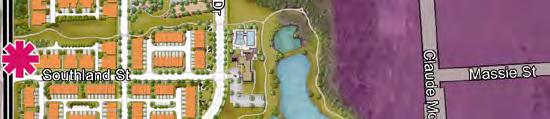


62
County of Loudoun. Department of Planning MEMORANDUM
 County of Loudoun Department of Planning MEMORANDUM DATE: April 18, 2013 TO: FROM: Jane McCarter, LEED AP, AICP, Project Manager Land Use Review Joseph Carter, AICP, CZA, Senior Planner Community Planning
THE TOWN OF CINCO BAYOU SIGN ORDINANCES ORDINANCE NO
 THE TOWN OF CINCO BAYOU SIGN ORDINANCES ORDINANCE NO. 200 83-7 83-7. Permitted temporary signs. Generally. The town recognizes that, by their nature, some signs are intended from their construction to
CHAPTER 6 - SIGNS AND BILLBOARDS (Ordinance #62)
") CHAPTER 6 - SIGNS AND BILLBOARDS (Ordinance #62) SECTION 601. INTENT AND PURPOSE The intent of this section is to regulate the type, number, physical dimensions, erection and placement of signs in Haring
CHAPTER 6 - SIGNS AND BILLBOARDS (Ordinance #62) SECTION 601. INTENT AND PURPOSE The intent of this section is to regulate the type, number, physical dimensions, erection and placement of signs in Haring
CITY OF TORONTO. BY-LAW No
 Authority: Planning and Growth Management Committee Item 40.12, as adopted by City of Toronto Council on August 25, 26 and 27, 2010 Enacted by Council: August 27, 2010 CITY OF TORONTO BY-LAW No. 1072-2010
2. A light fixture mounted above the sign face may be installed with its bottom opening tilted toward the sign face, provided:
 Section 20.132.090 Sign illumination. A. General. No temporary sign may be illuminated. No sign located in a residential zone may be illuminated, except that on parcels two (2) acres in size or greater,
ARTICLE 13 SIGNS. North Augusta Development Code 13-1
 TABLE OF CONTENTS Page 13.1 Purpose and Scope... 13-2 13.2 Applicability... 13-3 13.2.1 Definition... 13-3 13.2.2 Prohibition... 13-3 13.2.3 Permit Required... 13-3 13.2.4 No Content Restrictions... 13-3
Vintage and Nonconforming Amendments to Salt Lake City s Sign Ordinance
 BRIEFING MEMO PLANNING DIVISION DEPARTMENT of COMMUNITY and NEIGHBORHOODS ---------------------------------------------------------------------------------------------------------------------------------------------------------------------------------------
ORDINANCE NUMBER 2381
 Ordinance Number 2381 Page 1 ORDINANCE NUMBER 2381 AN ORDINANCE TO FURTHER AMEND THE ZONING ORDINANCE AND THE ZONING MAP OF THE CITY OF VESTAVIA HILLS, ALABAMA, ADOPTED SEPTEMBER 16, 1985, AND AS LAST
CITY OF WEST KELOWNA SIGN BYLAW NO A BYLAW TO REGULATE THE NUMBER, SIZE, TYPE, FORM, APPEARANCE AND LOCATION OF SIGNAGE
 CITY OF WEST KELOWNA SIGN BYLAW NO. 0250 A BYLAW TO REGULATE THE NUMBER, SIZE, TYPE, FORM, APPEARANCE AND LOCATION OF SIGNAGE WHEREAS the Council of the City of West Kelowna may by bylaw, as provided by
MAY 17, 2016 CITY COUNCIL STUDY SESSION POLICY DISCUSSION ON MEDICAL CANNABIS CULTIVATION FACILITIES
 MAY 17, 2016 CITY COUNCIL STUDY SESSION POLICY DISCUSSION ON MEDICAL CANNABIS CULTIVATION FACILITIES Staff Presentation 1. Overview of Ordinance 1083 and 1084 and discussion on allowing medical cannabis
STAFF REPORT Special Exception for a Medical Marijuana Dispensary in the Community Commercial Zoning District CASE NO
 STAFF REPORT Special Exception for a Medical Marijuana Dispensary in the Community Commercial Zoning District CASE NO. 17-70000001 REQUEST: PROPERTY OWNER: APPLICANT: To operate a medical marijuana dispensary
ORDINANCE AN ORDINANCE GRANTING A CABLE FRANCHISE FOR COMCAST
 1 STATE OF ILLINOIS ) COUNTY OF DEKALB ) )SS ORDINANCE 2006-01 AN ORDINANCE GRANTING A CABLE FRANCHISE FOR COMCAST WHEREAS, DeKalb County Ordinance 90-16 granted a cable television franchise to Warner
DEPARTMENT OF HEALTH AND MENTAL HYGIENE COMMISSIONER OF HEALTH AND MENTAL HYGIENE
 DEPARTMENT OF HEALTH AND MENTAL HYGIENE COMMISSIONER OF HEALTH AND MENTAL HYGIENE ----------------- NOTICE OF ADOPTION OF AMEDMENT OF CHAPTER 10 OF TITLE 24 OF THE RULES OF THE CITY OF NEW YORK In compliance
The following is a chronological list of ordinances pertaining to the off-sale of alcohol:
 COUNCIL AGENDA: 6/2/15 ITEM: 4.2 CITY OF SAN JOSE CAPITAL OF SILICON VALLEY TO: HONORABLE MAYOR AND CITY COUNCIL SUBJECT: SEE BELOW Memorandum FROM: Harry Freitas DATE: June 1,2015 Approved Date COUNCIL
Dilapidated sign means any sign that is structurally unsound, has defective parts, or is in need of painting or other maintenance.
 Community facilities are churches, schools, daycare centers, nursing homes, funeral homes, orphanages, and parks and recreation facilities which may be located in residential zoning districts. Construction
CITY OF TWINSBURG BOARD OF ZONING APPEALS MINUTES APRIL 8, 2015 CITY OF TWINSBURG BOARD OF BUILDING AND ZONING CODE APPEALS APRIL 8, 2015
 BOARD OF BUILDING AND ZONING CODE APPEALS Present: Absent: Also Present: Messrs: Gary Wilner, Ed Kancler, Thomas Brown and Brian Davis Neil Rubin Mr. Russ Rodic, Building Commissioner Mr. Sam Scaffide,
STAFF REPORT ACTION REQUIRED. Electronic and Illuminated Sign Study and Recommendations for Amendments to Chapter 694
 PG5.13 STAFF REPORT ACTION REQUIRED and Recommendations for Amendments to Chapter 694 Date: May 20, 2015 To: From: Ward: Reference Number: Planning and Growth Management Committee Chief Building Official
Recreational Marijuana Town of Mammoth Lakes Proposed implementation of Prop 64 April 26, 2017
 Recreational Marijuana Town of Mammoth Lakes Proposed implementation of Prop 64 April 26, 2017 Workshop summary Personal Use Taxation State licensing requirements for marijuana sales Current Town regulations
AN ORDINANCE OF THE BOARD OF COUNTY
 ORDINANCE NO. - AN ORDINANCE OF THE BOARD OF COUNTY COMMISSIONERS OF MARION COUNTY, FLORIDA, APPROVING AMENDMENTS TO THE MARION COUNTY LAND DEVELOPMENT CODE, ARTICLES 1 (ADMINISTRATION), AND (ZONING);
City of Santa Rosa Comprehensive Cannabis Ordinance & Program Implementation
 City of Santa Rosa Comprehensive Cannabis Ordinance & Program Implementation City Council December 12, 2017 Clare Hartman, Deputy Director - Planning Planning and Economic Development 1 Santa Rosa Cannabis
Village of Glenview Appearance Commission
 Village of Glenview Appearance Commission STAFF REPORT June 13, 2018 TO: Chairman and Appearance Commissioners FROM: Community Development Department CASE #: A2018-050 LOCATION: PROJECT NAME: 2200 Waukegan
City of Santa Rosa Comprehensive Cannabis Policy
 City of Santa Rosa Comprehensive Cannabis Policy Council Policy Subcommittee September 12, 2017 David Guhin, Director Clare Hartman, Deputy Director - Planning Planning and Economic Development 1 Santa
Planning Section, Community Development Division Development Services Department
 AGENDA ITEM: 2. DATE: 02-22-16 STAFF REPORT CONDITIONAL USE PERMIT NO. 15-21 DATE: TO: FROM: APPLICANT: LOCATION: REQUEST: Lancaster Planning Commission Planning Section, Community Development Division
A REGULAR MEETING OF THE PLAN COMMISSION OF THE VILLAGE OF BOLINGBROOK August 16, 2017
 A REGULAR MEETING OF THE PLAN COMMISSION OF THE VILLAGE OF BOLINGBROOK August 16, 2017 CALL TO ORDER Chairman Schank called the meeting to order at 7:58 p.m., Wednesday, August 16, 2017. ROLL CALL Present:
Commercial Cannabis Signage Ordinance
 Department of City Planning Case No. CPC-2017-4546-CA Commercial Cannabis Signage Ordinance Questions & Answers November 14, 2017 Summary The Commercial Cannabis Signage Ordinance is a proposed Los Angeles
Chapter 8. Appendices
 Chapter 8. Appendices Appendix A: Noise and Vibration Analysis Metro Gold Line Foothill Extension Phase 2A Supplemental EIR No. 2 for Additional Project Refinements MEMORANDUM To: From: Robb Fishman, Environmental
Medical Cannabis Uses
 Medical Cannabis Uses Comprehensive Ordinance Cannabis Policy Subcommittee February 16, 2017 David Guhin, Director Clare Hartman, Deputy Director-Planning Planning and Economic Development 1 City Response
Noise Ordinance Update PS&I 4/12/2018
 Noise Ordinance Update PS&I 4/12/2018 1 Noise Ordinance Update Questions/issues from previous PSI meeting Incentivizing mitigation of existing mechanical equipment noise Changing building code for more
ORDINANCE NO
 ORDINANCE NO. 02011-06 AN ORDINANCE OF THE CITY COUNCIL OF THE CITY OF YUMA, ARIZONA, AMENDING CHAPTER 154 OF THE YUMA CITY CODE, AS AMENDED, RELATING TO ZONING REGULATIONS, PROVIDING FOR CHANGES TO THE
MEMORANDUM INTRODUCTION. DATE: July 28, 2016; Revised August 3, 2016 TO:
 MEMORANDUM DATE: July 28, 2016; Revised August 3, 2016 TO: Lehigh Valley Planning Commission FROM: Becky Bradley, AICP, Executive Director CC: Staff REGARDING: Land Use Implications of the Medical Marijuana
ZONING COMPLIANCE REVIEW HEMP (ZCRH)
") ZONING COMPLIANCE REVIEW HEMP (ZCRH) FEMALE HEMP MALE/HERMAPHRODITE HEMP Hemp Establishment* is only permitted: in the A-1/A-2, Agricultural Zone Districts in a greenhouse, building, or outside farming
ZONING COMPLIANCE REVIEW HEMP (ZCRH) FEMALE HEMP MALE/HERMAPHRODITE HEMP Hemp Establishment* is only permitted: in the A-1/A-2, Agricultural Zone Districts in a greenhouse, building, or outside farming
Amending Your Land Use Bylaw To Prepare For The Retail Sale Of Cannabis
 1 Amending Your Land Use Bylaw To Prepare For The Retail Sale Of Cannabis The Federal Government has proposed that by July 2018 non -medical cannabis will be legalized in Canada. Currently, cannabis possession
PART USES ALLOWED WITHIN ZONING DISTRICTS. Sec Allowable Uses In Zoning Districts Table of Allowable Uses in Zoning Districts RD C
 Intent Statement The proposed amendment to the Land Development ode regarding medical marijuana dispensing facilities amends the ode to establish zoning and land development regulations related to the
Approval of the Sale of Tenleytown Chiller Site
 Planning, Program Development and Real Estate Committee Item V-E July 11, 2013 Approval of the Sale of Tenleytown Chiller Site Washington Metropolitan Area Transit Authority Board Action/Information Summary
3804: Medical and Retail Marijuana
 3804: Medical and Retail Marijuana A. Purpose and Intent: It is the purpose and intent of these regulations to govern the uses and activities associated with medical marijuana and retail marijuana and
HIGHLANDS COMMUNITY DEVELOPMENT DISTRICT
 SIXTH SUPPLEMENTAL ENGINEER S REPORT (Phase 3C Assessment Area) HIGHLANDS COMMUNITY DEVELOPMENT DISTRICT Prepared For: Board of Supervisors Highlands Community Development District Prepared By: Landmark
ORDINANCE NO
 Item 7 Attachment A ORDINANCE NO. 2017-355 AN ORDINANCE OF THE CITY COUNCIL OF THE CITY OF CALABASAS, CALIFORNIA, AMENDING CHAPTER 8.13 AND SECTION 17.12.125 OF THE CALABASAS MUNICIPAL CODE BY: 1) EXPANDING
An ordinance restricting commercial advertising of cannabis, cannabis products and cannabis activity on signs.
 ORDINANCE NO. An ordinance restricting commercial advertising of cannabis, cannabis products and cannabis activity on signs. THE PEOPLE OF THE CITY OF LOS ANGELES DO ORDAIN AS FOLLOWS: Section 1. A new
DeKalb County Government Public Meetings & Agendas. March 6 9, 2017 Monday 3/6 Tuesday 3/7 Wednesday 3/8 Thursday 3/9
 DeKalb County Government Public Meetings & Agendas Page 1 of 6 March 6 9, 2017 Monday 3/6 Tuesday 3/7 Wednesday 3/8 Thursday 3/9 Agenda -Page 2 Business Incubator Advisory Board 6 pm Location: Community
STAFF REPORT City of Lancaster NB 2
 STAFF REPORT City of Lancaster NB 2 12/13/16 MVB Date: December 13, 2016 To: From: Subject: Mayor Parris and City Council Members Mark V. Bozigian, City Manager Allison E. Burns, City Attorney Ordinance
ORDINANCE NO.: 1581.
 ORDINANCE NO.: 1581. AN ORDINANCE AFFECTING THE USE OF LAND IN THE CITY OF COCOA BEACH, FLORIDA RELATING TO MARIJUANA DISPENSARIES/MEDICAL MARIJUANA TREATMENT CENTERS, WHETHER FOR MEDICAL OR RECREATIONAL
ORDINANCE NO.: 1581.
 1 2 3 4 5 6 7 8 9 10 11 12 13 14 15 16 17 18 19 20 21 22 23 24 25 26 27 28 29 30 31 32 33 34 35 36 37 38 39 40 41 42 43 44 45 46 47 48 49 ORDINANCE NO.: 1581. AN ORDINANCE AFFECTING THE USE OF LAND IN
Signage on Construction Hoarding Phase III
 STAFF REPORT ACTION REQUIRED Signage on Construction Hoarding Phase III Date: July 28, 2010 To: From: Wards: Reference Number: Planning and Growth Management Committee General Manager, Transportation Services
Coouitlam _ ^ ~ For Council
 Coouitlam _ ^ ~ For Council January 29, 2013 Our File: 09-3900-30/12 015254 AB/l Doc#: 1399086.V1 To: From: Subject: For: City Manager General Manager Planning and Development Sign Amendment Bylaw No.
CORTE MADERA TOWN COUNCIL STAFF REPORT TOWN MANAGER, MAYOR AND MEMBERS OF THE TOWN COUNCIL KELLY CROWE, ASSOCIATE CIVIL ENGINEER
 CORTE MADERA TOWN COUNCIL STAFF REPORT REPORT DATE: October 12, 2016 MEETING DATE: October 18, 2016 TO: FROM: SUBJECT: PURPOSE: TOWN MANAGER, MAYOR AND MEMBERS OF THE TOWN COUNCIL KELLY CROWE, ASSOCIATE
ARTICLE 7: SIGN REGULATIONS
 ARTICLE 7: SIGN REGULATIONS Section 7.01 Purpose and Applicability A. Purpose The purpose of these sign regulations are: to encourage the effective use of signs as a means of communication in the City;
Marijuana Concentrate Processing within EFU or AG/F Districts (February 2018)
") CLACKAMAS COUNTY PLANNING AND ZONING DIVISION DEPARTMENT OF TRANSPORTATION AND DEVELOPMENT DEVELOPMENT SERVICES BUILDING 150 BEAVERCREEK ROAD OREGON CITY, OR 97045 503-742-4500 ZONINGINFO@CLACKAMAS.US
CLACKAMAS COUNTY PLANNING AND ZONING DIVISION DEPARTMENT OF TRANSPORTATION AND DEVELOPMENT DEVELOPMENT SERVICES BUILDING 150 BEAVERCREEK ROAD OREGON CITY, OR 97045 503-742-4500 ZONINGINFO@CLACKAMAS.US
BILL #261 CITY OF FERNLEY ORDINANCE #
 BILL #261 CITY OF FERNLEY ORDINANCE # AN ORDINANCE AMENDING TITLE 32, CHAPTER 49 OF THE FERNLEY MUNICIPAL CODE TO PERMIT MEDICAL MARIJUANA ESTABLISHMENTS; TO ALLOW MEDICAL MARIJUANA DISPENSARIES TO SELL
ORDINANCE BE IT ORDAINED BY THE CITY COUNCIL OF THE CITY OF CENTRALIA AS FOLLOWS: Section 1
 ORDINANCE 2330 AN ORDINANCE OF THE CITY OF CENTRALIA, WASHINGTON, ADDING A NEW CHAPTER TO TITLE 20 ZONING, OF THE CENTRALIA MUNICIPAL CODE (C.M.C) ENTITLED 20.65 RECREATIONAL MARIJUANA BUSINESS AND REPEALING
Sharon Call, Chairperson Mike Marchbanks, Commissioner Rob Kallas, Commissioner Kathy Moosman, Recorder
 The Lindon City held a regularly scheduled meeting on Tuesday, February 13, beginning at 7:00 p.m. at the Lindon City Center, City Council Chambers, 0 North State Street, Lindon, Utah. REGULAR SESSION
CITY OF WEST PALM BEACH DOWNTOWN ACTION COMMITTEE Meeting Date: May 15, 2018 Code Revision Case No
 CITY OF WEST PALM BEACH DOWNTOWN ACTION COMMITTEE Meeting Date: May 15, 2018 Code Revision Case No. 18-05 Regulations for Medical Marijuana Dispensaries I. REQUEST A city-initiated request for a text amendment
City Council Report 915 I Street, 1 st Floor Sacramento, CA
 City Council Report 915 I Street, 1 st Floor Sacramento, CA 95814 www.cityofsacramento.org File ID: 2018-00959 June 26, 2018 Public Hearing Item 28 Title: Ordinances Amending Title 5 and Title 17 Relating
Signage and Wayfinding Plan
 Signage and Wayfinding Plan with Standards and Specifications Produced By www.frankodesign.com Signage and Wayfinding Plan with Standards and Specifications The purpose of this sign plan is to take the
TABLE OF CONTENTS MARIJUANA PRODUCTION, PROCESSING, WHOLESALING, AND RETAILING. (Adopted 01/11/2016) SECTION TITLE PAGE 11.
 SECTION TITLE PAGE 11.") TABLE OF CONTENTS CHAPTER 11 MARIJUANA PRODUCTION, PROCESSING, WHOLESALING, AND RETAILING (Adopted 01/11/2016) SECTION TITLE PAGE 11.010 PURPOSES 11-2 11.020 APPLICABILITY 11-2 11.030 PROCEDURE 11-2 11.040
TABLE OF CONTENTS CHAPTER 11 MARIJUANA PRODUCTION, PROCESSING, WHOLESALING, AND RETAILING (Adopted 01/11/2016) SECTION TITLE PAGE 11.010 PURPOSES 11-2 11.020 APPLICABILITY 11-2 11.030 PROCEDURE 11-2 11.040
ANCHORAGE, ALASKA AR No
 Submitted by: Assembly Vice-Chair Traini Prepared by: Municipal Clerk s Office For reading: November 1, 201 ANCHORAGE, ALASKA AR No. 201-30 1 2 3 A RESOLUTION OF THE ANCHORAGE MUNICIPAL ASSEMBLY DIRECTING
Public Workshop Supervisorial District 5 April 17, 2017 Larch Clover Community Center
 Public Workshop Supervisorial District 5 April 17, 2017 Larch Clover Community Center 1 Workshop Agenda Overview of State Laws and Current County Ordinances Overview of Commercial Cannabis Business Types
Part Eleven: Sign Development Standards
 Part Eleven: Sign Development Standards Permitted and Discretionary Sign Uses by Land Use District... iii 11.1 Purpose... 1 11.2 Applicability... 1 11.3 Signs That Do Not Require a Development Permit...
COMMITTEE OF ADJUSTMENT AGENDA
 AGENDA Location: COUNCIL CHAMBER Hearing: APRIL 22, 2010 AT 1:30 P.M. 1. CALL TO ORDER 2. DISCLOSURES OF DIRECT OR INDIRECT PECUNIARY INTEREST 3. REQUESTS FOR WITHDRAWAL/DEFERRAL File Name of Applicant
Meeting Minutes Markings Technical Committee National Committee on Uniform Traffic Control Devices January 9-12, 2008 Arlington, VA
 Meeting Minutes Markings Technical Committee National Committee on Uniform Traffic Control Devices January 9-12, 2008 Arlington, VA I. Call to order (Gene Hawkins) A. Self introductions members and visitors
ORDINANCE NO. An ordinance enacting restrictions on commercial advertising of Cannabis and Cannabis Products on signs.
 ORDINANCE NO. An ordinance enacting restrictions on commercial advertising of Cannabis and Cannabis Products on signs. THE PEOPLE OF THE CITY OF LOS ANGELES DO ORDAIN AS FOLLOWS: Section 1. A new Article
Purpose. The City finds that signs provide an important medium through which individuals and businesses may convey a variety of messages.
 Chapter 3.6 Sections: SIGNS PC Final Draft to CC April 8, 2014 3.6.010 Purpose 3.6.020 Scope 3.6.030 Definitions 3.6.040 Exempted Signs 3.6.050 Prohibited Signs 3.6.060 Temporary Signs 3.6.065 Garage Sale
AGENDA SPECIAL MEETING OF THE CITY COUNCIL CITY OF BANNING BANNING, CALIFORNIA
 AGENDA SPECIAL MEETING OF THE CITY COUNCIL CITY OF BANNING BANNING, CALIFORNIA April 10, 2018 Banning Civic Center 1:30 p.m. Council Chamber 99 E. Ramsey Street I. CALL TO ORDER Roll Call Council Members
Applicant Submittal. Comprehensive Sign Submittal. BLUHAWK Development. 21 February Development:
 Comprehensive Sign Submittal BLUHAWK Development 21 February 2018 SHEET 100: EXPANDED SIGN IDENTIFICATION PACKAGE SHEET 101: OVERALL SITE SIGNAGE PLAN SHEET 210: HIGHWAY IDENTIFICATION - LOCATION PLAN
City of Sioux City Pierce Corridor Façade Improvement Program Guidelines
 I. Background City of Sioux City Pierce Corridor Façade Improvement Program Guidelines The Façade Improvement Program is a reimbursement grant program of the City of Sioux City to prevent or eliminate
A brief work session was held at 7:00pm. During the work session the board reviewed the applications on the agenda.
 Minutes of a regular meeting of the Johnson City Zoning Board of Appeals held on July 9, 2018 at 7:30pm at 243 Main St., Johnson City, NY Present: Absent: Leonard Sas, Vice Chairman Dr. Steve Holowinski
Welcome SIGN CODE UPDATE PUBLIC OPEN HOUSE COME BY AND GIVE US YOUR THOUGHTS ON AN IMPROVED CITY SIGN CODE. Foothills Activity Center Community Room
 Welcome SIGN CODE UPDATE PUBLIC OPEN HOUSE COME BY AND GIVE US YOUR THOUGHTS ON AN IMPROVED CITY SIGN CODE Foothills Activity Center Community Room Thursday, July 27, 2017 3:30 7:30 PM PROCESS AND HOW
MINUTES OF THE PLAN COMMISSION January 25, 2016
 MINUTES OF THE PLAN COMMISSION January 25, 2016 The regular meeting of the Plan Commission was called to order by Chairman Mark Moore at 8:10 p.m. at the Village Hall. Members present: Chairman Mark Moore,
REPORT. CITY CCUNCIl. Items. ACTION Medical Marijuana Text Amendment Initiation 65-PA-2016 APPLICANT CONTACT LOCATION. Meeting Date: March 29, 2016
 Items CITY CCUNCIl REPORT Meeting Date: March 29, 2016 General Plan Element: Land Use General Plan Goal: Create a sense of community through land uses ACTION Medical Marijuana Text Amendment Initiation
Minutes of the Planning Board of the Township Of Hanover December 18, 2018
 Page 1 of 9 Minutes of the Planning Board of the Township Of Hanover Chairman Eugene Pinadella called the Work Session Meeting to order at 7:01 PM in Conference Room A and The Open Public Meetings Act
Burlington Zoning Law, Article 13, Section limits a maximum of six (6) square feet. The proposed sign is 23 square feet.
 square feet. The proposed sign is 23 square feet.") Approved To Town Clerk MINUTES OF THE MEETING OF THE BOARD OF APPEALS BURLINGTON, MA June 6, 2017 Chairman John Alberghini called the meeting of the Burlington Board of Appeals to order at 7:30 p.m. The
Approved To Town Clerk MINUTES OF THE MEETING OF THE BOARD OF APPEALS BURLINGTON, MA June 6, 2017 Chairman John Alberghini called the meeting of the Burlington Board of Appeals to order at 7:30 p.m. The
ORDINANCE NO
 ORDINANCE NO. 01-2017 AN ORDINANCE OF THE CITY COUNCIL OF THE CITY OF SEMINOLE, FLORIDA, REGARDING MEDICAL CANNABIS; IMPOSING A TEMPORARY MORATORIUM ON THE SALE OF MEDICAL CANNABIS AND ON THE ESTABLISHMENT
2014 UPDATED YOLO COUNTY CODE. Title 8 LAND DEVELOPMENT CHAPTER 6: ALCOHOLIC BEVERAGE CONTROL ORDINANCE
 2014 UPDATED YOLO COUNTY CODE Title 8 LAND DEVELOPMENT CHAPTER 6: ALCOHOLIC BEVERAGE CONTROL ORDINANCE Sec. 8-6.101 Purpose The purpose of this Section is to establish permit requirement and development
Amend Zoning Bylaw, Medical Marijuana Treatment Centers
 Amend Zoning Bylaw, Medical Marijuana Treatment Centers To see if the Town will vote to amend Article IX (the Zoning Bylaw), as follows: A. To amend the Zoning Bylaw by repealing the Section 8000. Temporary
ADD THE FOLLOWING TO THE END OF SECTION 8 SPECIAL PROVISIONS - AS A NEW SECTION 8.11
 ADD THE FOLLOWING TO THE END OF SECTION 8 SPECIAL PROVISIONS - AS A NEW SECTION 8.11 8.11. Licensed Marijuana Establishments. A. Purpose. The purpose of this section is to provide for the placement of
Adopted May 3, 2011 by Apache County Board of Supervisors Draft for P & Z Commission December 2015
 2300 Section 2301. Definitions Medical Marijuana Designated Caregiver Cultivation Location An enclosed facility, that does not exceed 250 square feet of cultivation space, where a designated caregiver,
Guide to Public Participation. Addressing: Hearing Examiner Process
 Guide to Public Participation Addressing: Hearing Examiner Process COVER LAST REVISED 7/25/2014 GUIDE TO PUBLIC PARTICIPATION BEFORE THE HEARING EXAMINER FOR SPECIAL EXCEPTIONS, VARIANCES, AND REZONINGS
Chapter 4 NOISE Adopted: May 7, 1996
 NOISE Adopted: May 7, 1996 Last Revised: May 7, 1996 (Council Resolution No. 8535, 1996 Series) Please see the next page. Page 4-2 Noise Element CHAPTER 4 NOISE ELEMENT TABLE OF CONTENTS INTRODUCTION...
DRAFT County Registration Form Medical Cannabis Cultivation and Future Non-Medical Cannabis Cultivation and Related Operations
 Introduction ATTACHMENT 2B DRAFT County Registration Form Medical Cannabis Cultivation and Future Non-Medical Cannabis Cultivation and Related Operations If you are growing cannabis under the personal
MEMO TO: Plan Commission FROM: Robert E. Pfeil, Village Planner. DATE: September 2, 2011 SUBJECT:
 MEMO TO: FROM: Plan Commission Robert E. Pfeil, Village Planner DATE: September 2, 2011 SUBJECT: Zoning Ordinance amendments concerning storage and sale of propane at commercial properties Workshop #2
City of Sanibel. Planning Department STAFF REPORT
 City of Sanibel Planning Department STAFF REPORT Planning Commission Meeting: July 10, 2012 Planning Commission Agenda Item: No. 6 Application Number: Evaluation & Appraisal of the Sanibel Plan Applicant
TITLE 22 - ZONING CHAPTER MEDICAL MARIJUANA DISPENSARIES AND CULTIVATION
 CHAPTER 22.41 MEDICAL MARIJUANA DISPENSARIES AND CULTIVATION CHAPTER 22.41 MEDICAL MARIJUANA DISPENSARIES AND CULTIVATION [1] 22.41.010 Purpose. 22.41.020 Medical Marijuana Dispensary. 22.41.025 Cultivation
Proposed Regulation Updates. Pa Code, Title 67, Chapter 441. Access to and Occupancy of Highways by Driveways and Local Roads
 Proposed Regulation Updates Pa Code, Title 67, Chapter 441 Access to and Occupancy of Highways by Driveways and Local Roads Chapter 441 update History Last update occurred in 1992 2004 attempted update
WHEREAS, the Board desires to provide regulations pertaining to the location, land use, appearance, and signage of medical marijuana uses; and
 BILL NO. 2013-3 1 NYE COUNTY ORDINANCE NO. SUMMARY: A Bill proposing to amend Nye County Code Title 17, the Zoning Ordinance of the Pabrump Regional Planning District, by adding Section 17.04.870 Medical
Honorable Mayor and Members of the City Council. Mitigation Agreement with Safeway for Expansion at 6310 College Avenue, Oakland
 Public Works Department CONSENT CALENDAR July 17, 2012 To: From: Honorable Mayor and Members of the City Council Christine Daniel, City Manager Submitted by: Andrew Clough, Director, Public Works Subject:
Five Ways, Five Ways/ Broad Street, Birmingham, B15 1DL. Display of 1 no. digital 96 sheet advertisement display
 Committee Date: 7/07/04 Application Number: 04/03/PA Accepted: /05/04 Application Type: Advertisement Target Date: 6/07/04 Ward: Ladywood Five Ways, Five Ways/ Broad Street, Birmingham, B5 DL Display of
CALL FOR REVIEW OF HEARING OFFICER'S DECISION: EXPRESSIVE USE PERMIT #6052, AND ASSOCIATED VARIANCE, AT 25 NORTH RAYMOND AVENUE ('NEW YORK DELl')
") ,1,' po May 20, 2013 TO: FROM: SUBJECT: Honorable Mayor and City Council Planning & Community Development Department CALL FOR REVIEW OF HEARING OFFICER'S DECISION: EXPRESSIVE USE PERMIT #6052, AND ASSOCIATED
,1,' po May 20, 2013 TO: FROM: SUBJECT: Honorable Mayor and City Council Planning & Community Development Department CALL FOR REVIEW OF HEARING OFFICER'S DECISION: EXPRESSIVE USE PERMIT #6052, AND ASSOCIATED
of CREVE COEUR 300 North New Ballas Road Creve Coeur, Missouri (314) Fax (314) Relay MO
 Fax (314) Relay MO") city of CREVE COEUR 300 North New Ballas Road Creve Coeur, Missouri 63141 (314) 432-6000 Fax (314) 872-2539 Relay MO 1-800-735-2966 www.creve-coeur.org Corrected NOTICE OF PUBLIC HEARING APPLICATION TO
city of CREVE COEUR 300 North New Ballas Road Creve Coeur, Missouri 63141 (314) 432-6000 Fax (314) 872-2539 Relay MO 1-800-735-2966 www.creve-coeur.org Corrected NOTICE OF PUBLIC HEARING APPLICATION TO
California Comprehensive Addiction Recovery Act; Physical Capacity Expansion for Addiction Treatment
 California Comprehensive Addiction Recovery Act; Physical Capacity Expansion for Addiction Treatment (a) The Legislature finds and declares all of the following: 1. There are only 25 hospitals in California
In June 2017, Governor Brown signed Senate Bill 94, the Medicinal and Adult-Use Cannabis Regulation
 * CIT WICO City Council Agenda Report Meeting Date: September 19, 2017 TO: Honorable Mayor and City Council CC: Mark Orme, City Manager Debbie Presson, City Clerk Michael O'Brien, Chief of Police FROM:
Expanded Protections Dining areas No smoking where food is served in outdoor dining areas of restaurants, cafes and coffee shops as of November 2010
 Requirements for Multi-Unit Housing Complexes On April 24, 2010 a new ordinance (San Francisco Health Code Article 19F) that expanded protection from second hand smoke went into effect. The table below
FRAMEWORK FOR REGULATING CANNABIS IN THE UNINCOPORATED AREA OF CONTRA COSTA COUNTY
 PRELIMINARY WORKING DRAFT FRAMEWORK FOR REGULATING CANNABIS IN THE UNINCOPORATED AREA OF CONTRA COSTA COUNTY PREPARED FOR THE CONTRA COSTA COUNTY BOARD OF SUPERVISORS BY THE CONTRA COSTA COUNTY DEPARTMENT
Personal Cannabis Cultivation Ordinances. Napa County Board of Supervisors 6/19/18
 Personal Cannabis Cultivation Ordinances Napa County Board of Supervisors 6/19/18 Today s Item Adoption of two ordinances: Adoption of draft ordinance amending Ch. 8.10 allowing outdoor cultivation of
AS AMENDED A BILL WHEREAS, WHEREAS WHEREAS, WHEREAS, WHEREAS WHEREAS, WHEREAS,
 1 1 0 1 0 1 BY AUTHORITY ORDINANCE NO. COUNCIL BILL NO. CB-01 SERIES OF 0 COMMITTEE OF REFERENCE: AS AMENDED 0-1- Special Issues: Marijuana Moratorium A BILL For an ordinance concerning the licensing of
Welcome to the AccessibilityOnline Webinar Series. A collaborative program between the ADA National Network and the US Access Board
 Welcome to the AccessibilityOnline Webinar Series A collaborative program between the ADA National Network and the US Access Board The Session is Scheduled to begin at 2:30pm Eastern Time We will be testing
Case To: Oxford Board of Adjustment From: Benjamin Requet, Senior Planner Date: January 09, 2017
 Case 2143 To: Oxford Board of Adjustment From: Benjamin Requet, Senior Planner Date: January 09, 2017 Applicant: Sydicated Investment Owner: Same Request: Site Plan Approval O Bryan Property Location:
(Council File No ; CPC SP)
") Holly L. Wolcott City Clerk 200 N. Spring St., Rm. 360 Los Angeles, CA 90012 Attn: Sharon Dickinson Re: Ordinance Amending The Los Angeles Sports and Entertainment District (LASED) Specific Plan, Increasing
Holly L. Wolcott City Clerk 200 N. Spring St., Rm. 360 Los Angeles, CA 90012 Attn: Sharon Dickinson Re: Ordinance Amending The Los Angeles Sports and Entertainment District (LASED) Specific Plan, Increasing
An ordinance restricting commercial advertising of cannabis, cannabis products and cannabis activity on signs.
 ORDINANCE NO. An ordinance restricting commercial advertising of cannabis, cannabis products and cannabis activity on signs. THE PEOPLE OF THE CITY OF LOS ANGELES DO ORDAIN AS FOLLOWS: Section 1. A new
Memorandum. Date: November 21, Government Employees
 State of California Memorandum Department of Health Services Date: November 21, 2003 To: From: Government Employees Dileep G. Bal, M.D., Chief Cancer Control Branch 1616 Capitol Avenue, Suite 74.516 MS
AN ORDINANCE NO. 4129
 AN ORDINANCE NO. 4129 AN ORDINANCE To Amend The Code Of The Township Of Lower Merion, Chapter 155 To Provide Definitions Of Academic Clinical Research Center, Caregiver (Medical Marijuana), Certified Medical