North Tarrant Express Segments 2-4. Draft List of Facilities
|
|
|
- Irene Small
- 5 years ago
- Views:
Transcription

1 MASTER DEVELOPMENT PLAN NORTH TARRANT EXPRESS, SEGMENTS 2-4 North Tarrant Express Segments 2-4 Copyright 2010, NTE Mobility Partners 2-4, LLC Revision: 0 Revisions Effective Date: 3/30/10 Number Date Prepared by Reviewed by NTE Mobility Partners 2-4, LLC 0 3/30/ /04/ /12/10 Approved by i
2 Table of Contents 1. Introduction Interim vs. Ultimate Configuration for the Remaining Segments of NTE Characteristics of Project Segments All Segments Segment 2E Segment 3A IH 35 / IH 820 Interchange (Segment 1A) Segment 3B Segment 3C Segment Index of Tables Table 1: Characteristics of Project Segments... 5 Index of Figures Figure 1: North Tarrant Express Segment Map... 4 Figure 2: Typical Section Segment 2E Interim Configuration Elevated Westbound Managed Lane Sections... 9 Figure 3: Typical Section Segment 2E Ultimate Configuration (TxDOT-Provided Schematic) Elevated Westbound Managed Lane Sections Figure 4: Typical Section Segment 2E Interim Configuration Bear Creek Parkway / American Blvd Figure 5: Typical Section Segment 2E Ultimate Configuration (TxDOT-provided schematic) West of American Blvd. / Bear Creek Parkway, Approaching Interchange with SH Figure 6: Segment 2E Stick Diagram Ultimate Configuration Figure 7: Typical Section Segment 3A Interim Configuration Figure 8: Typical Section Segment 3A Ultimate Configuration Figure 9: Stick Diagram Segments 3A and 3B Ultimate Configuration Figure 10: Typical Section Interim Configuration of Segment 3B South of US Figure 11: Typical Section Ultimate Configuration of Segment 3B South of US Figure 12: Typical Section Segment 3C Ultimate Configuration (TxDOT-Provided Schematic) Figure 13: Stick Diagram Segment 3C Ultimate Configuration Figure 14: Typical Section Segment 4 Ultimate Configuration Figure 15: Stick Diagram Segment 4 Ultimate Configuration ii
3 1. Introduction The North Tarrant Express (NTE) Project is dedicated to improving mobility and connectivity along an approximately 37-mile corridor encompassing portions of IH 35W, IH 820 and SH 121/183 Airport Freeway in northern Tarrant County through a regionally supported managed lane system. The first phase of NTE, known as the Concession Facility (Segments 1 and 2W), will rebuild and expand approximately 13 miles along IH 820 and SH 121/183, adding four tolled Managed Lanes, plus frontage roads and auxiliary lanes to approximately double the existing capacity. The ultimate configuration of the Concession Facility, developed when a certain level of demand is recorded, also includes two additional non-tolled main lanes. The Concession Facility is expected to be operational by This discusses NTE Segments 2E-4 ( the Project ), which are the additional Segments planned for construction following the Concession Facility. These Segments, totaling approximately 24 miles, will expand and rebuild SH 183 east of the Concession Facility, extend the Project on IH 820 and SH 121 south of the Concession Facility, and improve mobility on IH 35W north and south of IH 820. Each Segment will include three to four General Purpose Lanes and two to three Managed Lanes, as further detailed in this report. The Project includes 10 major interchanges and numerous connections to local roads. NTEMP24 is carrying out traffic and revenue analysis to optimize and evaluate the configuration and feasibility of all Segments. This feasibility analysis centers on determining the optimal balance between relieving congestion on the General Purpose Lanes and driving sufficient traffic and revenue to the Managed Lanes to sustain the goal of constructing the Project while minimizing the use of public subsidies. Details of the traffic and revenue analysis will be provided in the Preliminary Project Traffic and Revenue Report in Milestone 4. The Draft Facilities Report, also to be provided in Milestone 4, will include a plan for phasing and sequencing the interim and ultimate buildouts of each Segment, including phasing parameters. 2. Interim vs. Ultimate Configuration for the Remaining Segments of NTE When discussing the different alternatives to deliver the remaining segments of the NTE system, NTEMP24 has focused on those that optimize the feasibility of the Project. The public-private collaboration between NTEMP24 and TxDOT brings together additional resources for financing, design, construction, operations and maintenance. Under those premises, NTEMP2-4 has identified Design-Build, Design-Bid-Build and Comprehensive Development Agreements as the best options for TxDOT. 1
4 One additional constraint is the availability of public funds to be earmarked for the implementation and long-term obligations associated with these large infrastructure projects. Taking into consideration the limited resources both from the State and the federal government, our primary goal in the endeavor of preparing the Master Development Plan for the North Tarrant Express system has been to minimize the amount of public funds required while maximizing the additional capacity that can be added in the short term. Adding up all these factors, NTEMP24 has tried to optimize the revenue generation capacity of each Segment while ensuring that the users are provided with sufficient alternatives to avoid the inconvenience associated with long daily commutes due to congested roads. In our plan, the Managed Lanes are added in the first stage of the development of each Segment, providing four additional lanes as an alternative to those who are willing to pay in order to avoid congestion. We cannot forget that by shifting traffic into the Managed Lanes, the flow on the General Purpose Lanes will be improved at no cost to those users since the existing capacity of General Purpose Lanes will be maintained when the Managed Lanes are built. Additional benefits to the traveling public in the short term include improvements to some ramps, a smoother alignment where possible, etc. Design and construction of the interim configuration will take into consideration the future expansion that will accommodate the ultimate configuration envisioned by TxDOT and reflected in the schematics that are part of the environmental approval. Thus, the construction will occur at the time when the additional lanes are required, minimizing both the cost of those future expansions and the disturbance to traffic. The triggers for future expansions will be based on one the following principles, depending on the actual financial outcome that will be carried out as part of Milestone 4: Date-Based Triggers: Similarly to the requirements on the CDA for Segments 1 and 2W, the concessionaire may be required to add capacity by a certain date, regardless of the actual demand. Revenue-Based Triggers: This option is also contemplated in the CDA for Segments 1 and 2W; the mechanism works according to the following principle: if the project is performing better than expected, when the amount of revenues in excess of the base case is enough to cover the cost of the widening plus the compensation to the concessionaire due to the decrease of traffic in the Managed Lanes as a result of the additional lane capacity, then new General Purpose Lanes, Frontage Roads and/or Managed Lanes will be constructed. 2
5 TxDOT s Discretion: At all times, TxDOT will have the ability to request the concessionaire to build additional capacity, provided that the actual compensation is paid at the time. As noted above, these alternatives will be further explored on Milestone 4, combining the actual technical aspects such as traffic demand, construction costs and operational impacts with the financial implications, in order to determine which options are optimal for each Segment. 3. Characteristics of Project Segments The characteristics of each Segment are described in this section. A map of the Project is provided as Figure 1. 3


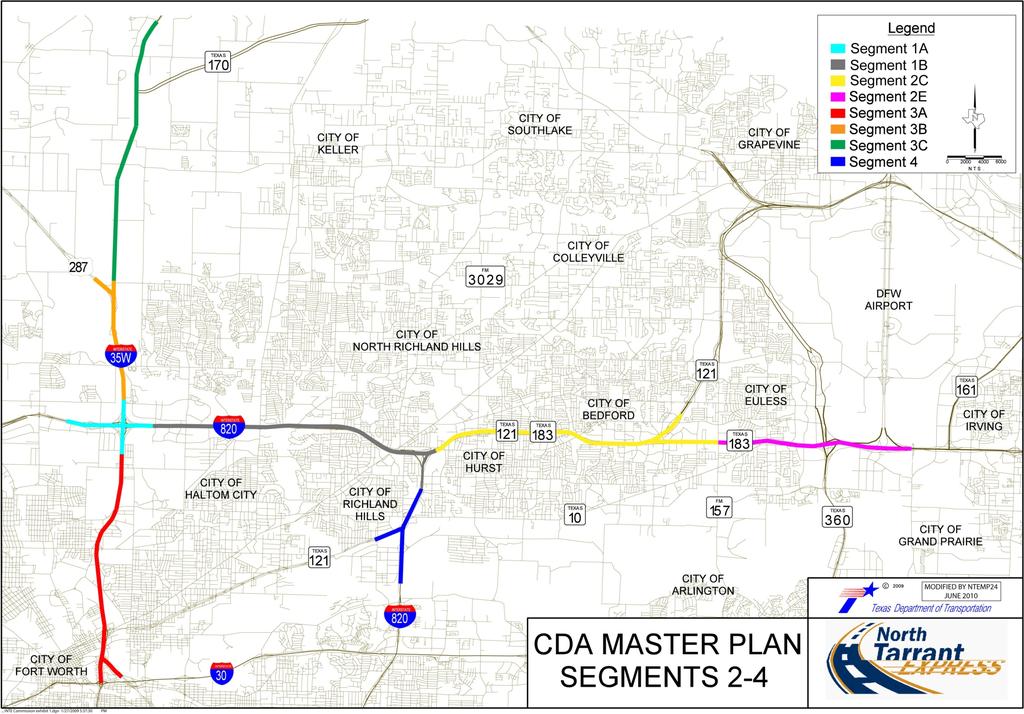
6 Figure 1: North Tarrant Express Segment Map 4
7 3.1 All Segments The characteristics of each Segment are described in Table 1. Table 1: Characteristics of Project Segments Segment ID Geographical Limits Number, Type and Width of Lanes (by direction) Length (miles) General Purpose Capacity (by direction) Major (Multi-Level Interchange) Interconnections Minor (Minor Interchange or Grade Separation) Overall Benefit to Corridor Political Support Development Factors Viable / Minimize Public Funds Construction Cost Environmental Progress 2E Interim 2E Ultimate NTE Segment 2C (SH 183) at Industrial Blvd. (FM 157) County Line Road 3 12 GP 2 12 ML 2-12 Frontage Roads 3 12 GP 3 12 ML 2-12 Frontage Roads lanes 3 lanes SH 360 DFW International Parkway N. Industrial Blvd. (FM 157) Manchester Dr. N. Ector Dr. Byers St. N. Euless Main Street SH 10 American Blvd / Bear Creek Pkwy. Amon Carter Blvd. 3A Interim 3A Ultimate Meacham Blvd. IH GP 2 12 ML 2-12 Frontage Roads 4 12 GP 2 12 ML 2-12 Frontage Roads lanes Meacham to SH lanes SH 183 to IH 30 Spur 280 SH 121 / US 377 Meacham Blvd. SH 183 / 28th St. Fourth St. Pharr St. FW & Western RR/ Long St. BNSF RR/Dooling St. UPRR Yucca / E. Northside Dr. 4 lanes Sylvania SH 121 DART RR Luella St. 5
8 Segment ID Geographical Limits Number, Type and Width of Lanes (by direction) Length (miles) General Purpose Capacity (by direction) Major (Multi-Level Interchange) Interconnections Minor (Minor Interchange or Grade Separation) Overall Benefit to Corridor Political Support Development Factors Viable / Minimize Public Funds Construction Cost Environmental Progress GP plus auxiliary lanes IH 35 / IH 820 Interchange Interim (Base Case and Alternative 1) IH 35W / IH 820 IH 35W / IH ML on IH 35W ML on IH Frontage Roads One-lane non-tolled Direct Connectors 3 12 GP plus auxiliary lanes 1.70 along IH 35W / 1.87 along IH Lanes IH35/IH820 Mark IV Parkway N/A 2 12 ML IH 35 / IH 820 Interchange Ultimate 2-12 Frontage Roads Non-tolled Direct Connectors as shown on TxDOT schematics for environmental approval 3B Interim Between Fossil Creek and Western Center Blvd. North Tarrant Parkway GP ML Frontage Roads lanes US 81 / 287 Basswood Blvd. Western Center Blvd. 6
9 Segment ID Geographical Limits Number, Type and Width of Lanes (by direction) Length (miles) General Purpose Capacity (by direction) Major (Multi-Level Interchange) Interconnections Minor (Minor Interchange or Grade Separation) Overall Benefit to Corridor Political Support Development Factors Viable / Minimize Public Funds Construction Cost Environmental Progress GP 3B Ultimate ML Frontage Roads 3 lanes Basswood Blvd. Western Center Blvd. North Tarrant Parkway 3C NTE Segment 3B (US 287) 0.16 mile south of Eagle Parkway 3 12 GP 2 12 ML 2-12 Frontage Roads lanes SH 170 North Tarrant Parkway Heritage Trace Parkway Golden Triangle Blvd. Keller-Hicks Rd. Westport Parkway Alliance Blvd. Texas Longhorn Way 3 to 4 12 GP 4 2C (IH 820/SH 121/SH 183). Randol Mill Road 1 14 ML (as shown on current conceptual schematic) 2-12 Frontage Roads to 4 lanes IH 820/SH 121 IH 820/SH 121/ SH 183 Randol Mill Rd. Trinity Blvd. Handley-Ederville Rd. SH 10 (Hurst Blvd.) Glenview Dr. / W. Pipeline Rd. Notes: All improvements are proposed as mixed-use. Lengths shown are approximate and may not reflect the length of all elements within each Segment. Positive Influencing Factor Neutral Influencing Factor Negative Influencing Factor 7
10 3.2 Segment 2E Segment 2E extends 4.5 miles along the existing SH 183 (Airport Freeway), from NTE Segment 2C (SH 183) at Industrial Blvd. (FM 157) eastward to the County Line Road, which is 0.77 miles east of International Parkway, DFW International Airport s principal north-south arterial road. Portions of Segment 2E are located in the cities of Fort Worth, Euless and Bedford. Segment 2E includes a stream crossing at Big Bear Creek and no rail crossings. The interim configuration of Segment 2E consists of three 12-foot General Purpose Lanes (matching existing capacity), two 12-foot Managed Lanes and two-lane frontage roads in each direction. The ultimate configuration of Segment 2E contains one additional Managed Lane. East of SH 360, the westbound Managed Lanes begin at International Parkway and the eastbound Managed Lanes end at Amon Carter Blvd. From the connection with the Concession Facility to west of American Blvd. / Bear Creek Parkway, the Segment 2E Managed Lanes are located in the center of the freeway, between the eastbound and westbound General Purpose Lanes. From the connection with the permanent construction of the Concession Facility to Manchester Drive, the westbound Managed Lanes are elevated and the eastbound Managed Lanes are at grade (see Figures 2 and 3). From Manchester Drive to Byers St., all Managed Lanes are on a fill retaining wall section. The Managed Lanes are elevated in both directions from Byers St. to east of the connection with International Parkway. West of American Blvd. / Bear Creek Parkway, the elevated Managed Lanes diverge to the outside of the General Purpose Lanes to accommodate the interchanges at SH 360 and International Parkway (see Figures 4 and 5). 8
11 Figure 2: Typical Section Segment 2E Interim Configuration Elevated Westbound Managed Lane Sections 9
12 Figure 3: Typical Section Segment 2E Ultimate Configuration (TxDOT-Provided Schematic) Elevated Westbound Managed Lane Sections Figure 4: Typical Section Segment 2E Interim Configuration Bear Creek Parkway / American Blvd. 10
13 Figure 5: Typical Section Segment 2E Ultimate Configuration (TxDOT-provided schematic) West of American Blvd. / Bear Creek Parkway, Approaching Interchange with SH
14 Segment 2E contains toll gantries in the following locations: Eastbound (overhead) east of SH 121 (2E-1) Eastbound at SH 10, at entrance ramp from Frontage Road (2E-2) Eastbound at International Parkway, accessible from the Frontage Roads and General Purpose Lanes (2E-3) Westbound at International Parkway: at entrance from General Purpose Lanes (2E-4) at entrance ramp from Frontage Road (2E-5) Westbound east of SH 360, at entrance ramp from Frontage Road (2E-6) 12
15 A stick diagram of Segment 2E is provided in Figure 6. Figure 6: Segment 2E Stick Diagram Ultimate Configuration 13
16 3.3 Segment 3A Segment 3A is 5.4 miles long and runs north-south along the existing IH 35W from Meacham Blvd. to IH 30, within the Fort Worth city limits. Segment 3A includes crossings of the West Fork Trinity River in two locations IH 35W South of E. Northside Dr. / Yucca Ave. and on SH 121 east of Oakhurst Scenic Dr. Segment 3A includes rail crossings at the following locations: E. Long Ave Fort Worth and Western RR Dooling St. Burlington Northern-Santa Fe (BNSF RR) Wautaga Rd. Union Pacific (UPRR), Fort Worth Belt RR South of Fourth St. DART / Trinity Railway Express NTEMP24 has proposed a number of changes to TxDOT s original schematic for Segment 3A, for the purposes of financial feasibility while providing better connectivity and enhanced mobility. NTEMP24 s proposed interim configuration of Segment 3A maintains the existing capacity of the General Purpose Lanes, with two to three General Purpose Lanes, two Managed Lanes and two-lane frontage roads. In some areas, auxiliary lanes and other lanes may be provided to achieve lane balance. (See Figure 7) The proposed ultimate configuration of Segment 3A contains four General Purpose Lanes, two Managed Lanes and two-lane Frontage Roads, with auxiliary lanes and other lanes provided to achieve lane balance. (See Figure 8). 14
17 Figure 7: Typical Section Segment 3A Interim Configuration Note: Interim Frontage road not continuous. See Proposal Schematics for more details. Interim GPL capacity will match Existing Capacity. Figure 8: Typical Section Segment 3A Ultimate Configuration Note: Ultimate Frontage road not continuous. See NTE MP 2-4 Ultimate schematics for more details 15
18 The main differences between the TxDOT schematic and the proposed interim configuration of Segment 3A include: Managed Lane entrance and exit ramps have been extended nearly one mile further south. The northbound General Purpose Lanes on IH 35W have been shifted slightly west between the pair of Managed Lane entrance and exit ramps north of northeast 28th St. / SH 183 to improve stopping sight distance. The number of Managed Lanes has been increased from one to two lanes in each direction south of the Trinity River. The curvature of entrance ramps and direct connectors has been revised in certain locations to comply with the technical requirements. Managed Lane connections have been added at Northbound US 287 to Northbound IH 35W and Southbound IH 35W to Southbound US 287 to accommodate Managed Lane connections to the existing IH 30. Adding Managed Lane connections between IH 35W and US 287 is expected to improve connectivity between the Project and IH 30. Traffic flow between the Project and IH 30 may also be improved by deferring construction of the interchange at SH 121. Preliminary analysis indicates that postponing construction of this interchange will attract more traffic to both Segment 3A and IH 30, improving the feasibility of Segment 3A and attracting traffic to facilities with more available capacity than SH 121, thereby improving overall mobility. Further, deferment of this construction will improve financial feasibility while providing better project connectivity and enhanced mobility. The Draft Facilities Report to be provided in Milestone 4 will discuss optimal phasing of the interchange at SH 121. Segment 3A includes toll gantries in the following locations: Northbound at the entrance ramp north of Luella St. (3A-1) Northbound, north of Spur 280, at entrance from General Purpose Lanes (3A-2) Northbound, just south of the Trinity River, at entrance from General Purpose Lanes (3A-3) Northbound, south of Dooling Street, accessible from frontage road and General Purpose lanes (3A-4) Southbound, south of Polaris Drive, at entrance from General Purpose Lanes (3A-6) SH 121 Eastbound Direct Connector to IH 35W Managed Lanes (3A-7) 16
19 A stick diagram of Segments 3A, 3B and the IH 35W / IH 820 Interchange is provided in Figure 9. Figure 9: Stick Diagram Segments 3A and 3B Ultimate Configuration 17
20 3.4 IH 35 / IH 820 Interchange (Segment 1A) The IH 35 / IH 820 Interchange (Segment 1A) is located within the city limits of Fort Worth. Segment 1A extends approximately 1.7 miles along IH 35W and 1.9 miles along IH 820. It is bordered in the north by NTE Segment 3B, in the South by NTE Segment 3A, in the East by NTE Segment 1B (Concession Facility) and on the West it will merge with the existing infrastructure just west of Mark IV Parkway (Approx. Station ). Segment 1A provides continuity to the Managed Lanes on IH 35W by connecting the Managed Lanes of NTE Segments 3A and 3B. It also extends the Managed Lanes on IH 820 further west of IH 35W. Besides the main interchange, the only major intersection on this Segment is Mark IV Parkway located on the west side of Segment 1A on IH Ultimate Configuration The ultimate configuration of Segment 1A includes one-lane tolled Managed Lane-to- Managed Lane Connectors from IH 820 westbound to IH 35W northbound and southbound (The reverse movement is being built under the NTE Segment 1A concession). Non-tolled direct connectors include: southbound IH 35W to eastbound and westbound IH 820; northbound IH 35W to eastbound and westbound IH 820; westbound IH 820 to northbound and southbound IH 35W; and eastbound IH 820, to northbound and southbound IH 35W. The ultimate configuration of the Segment 1A will include three continuous General Purpose Lanes per direction on IH 35W, and IH 820 and will provide Frontage Road connections between: southbound IH 35W to westbound IH 820; eastbound IH 820 to southbound IH 35W; northbound IH 35W to eastbound IH 820; and westbound IH 820 to northbound IH 35W. 18
21 3.4.2 Alternatives for Interim Configuration The interchange between IH 35W and IH 820 is one of the most complex elements that remain to be developed as part of the NTE system. At this stage, several different alternatives are being considered, following the same rationale discussed for the actual development of Segments 2E, 3A, 3B, 3C and 4, which is to optimize the initial investment in order to minimize the need of public funds while providing improvements that address current and future demand. Similarly to the discussion regarding the interim and ultimate configuration for the other Segments, in order to minimize the amount of public funds required, NTEMP2-4 has analyzed several configurations that range from maximizing use of the existing interchange to a complete reconstruction of the existing infrastructure as contemplated in the ultimate schematics developed by TxDOT. The most relevant alternatives are described in detail below. The different alternatives begin with those that attempt to utilize as much of the existing interchange as possible while providing additional elements that are considered to be the most critical for the feasibility of the project (Options A and B). Finally, Option C involves construction of the majority of the components of the new interchange as contemplated in the schematics developed by TxDOT for the environmental process. This notwithstanding, NTEMP2-4 will explore additional options during the preparation of Milestone 4 of this MDP. Option A Under this alternative, the improvement of Segment 1A includes constructing Managed Lane-to-Managed Lane direct connectors from westbound IH 820 to northbound and southbound IH 35W. The scope of work for Option A is detailed below: Option B Construct the IH 820 westbound to IH 35 southbound Managed Lane-to- Managed Lane direct connector Construct the IH 820 westbound to IH 35 northbound Managed Lane-to- Managed Lane direct connector Construct the necessary infrastructure to allow construction of the westbound IH 820 to northbound and southbound IH 35W Managed Laneto-Managed Lane direct connectors As a second level, the improvement of Segment 1A includes building the northbound and southbound IH 35W Managed Lanes across IH 820, and building Managed Laneto-Managed Lane Connectors from westbound IH 820 to northbound and southbound IH 35. These improvements will increase capacity and decrease congestion. Option B 19
22 would increase the IH 35W northbound and southbound through lane highway capacity across IH 820 by 100 percent (four through lanes vs. the current two lanes per direction). The scope of work for Option B is detailed below: Option C Construct northbound and southbound IH 35W Managed Lanes Construct the IH 820 westbound to IH 35 southbound Managed Lane-to- Managed Lane Direct Connector Construct the IH 820 westbound to IH 35 northbound Managed Lane-to- Managed Lane Direct Connector Construct the necessary infrastructure to allow construction of the aforementioned IH 35W Managed Lanes, and geometrically adequate transitions to NTE Segments 3A and Segment 3B Construct the necessary infrastructure to allow construction of the westbound IH 820 to northbound and southbound IH 35W Managed Laneto-Managed Lane Connectors Finally, the improvement of Segment 1A includes extending the IH 820 eastbound and westbound Managed Lanes to the west side of IH 35W, building the northbound and southbound IH 35W Managed Lanes across IH 820, and building Managed Lane-to- Managed Lane Connectors from westbound IH 820 to northbound and southbound IH 35. These improvements will increase capacity and decrease congestion. Option C would increase the IH 820 eastbound and westbound through lane capacity across IH 35W by 50 percent (three through lanes vs. the current two lanes per direction). Option C would also increase the IH 35W northbound and southbound through lane highway capacity across IH 820 by 100 percent (four through lanes vs. the current two lanes per direction). The scope of work for Option C is detailed below: Construct northbound and southbound IH 35W Managed Lanes Construct eastbound and westbound IH 820 Managed Lanes Construct the IH 820 westbound to IH 35 southbound Managed Lane-to- Managed Lane Connector Construct the IH 820 westbound to IH 35 northbound Managed Lane-to- Managed Lane Connector Construct the necessary infrastructure to allow construction of the aforementioned IH 35W Managed Lanes, and geometrically adequate transitions to existing General Purpose Lanes at both ends of the IH 35W Managed Lanes 20
23 Construct the necessary infrastructure to allow construction of the IH 820 Managed Lanes, and geometrically adequate transitions to existing General Purpose Lanes on the west side of the IH 35W Managed lanes Construct the necessary infrastructure to allow construction of the westbound IH 820 to northbound and southbound IH 35W Managed Laneto-Managed Lane Connectors The project limits for Option C are described below: Managed Lanes: Connectors: IH 35W northbound ML: IH 35W centerline station to IH 35W centerline station IH 35W southbound ML: IH 35W centerline station to IH 35W centerline station IH 820 eastbound ML: IH 820 centerline station to IH 820 centerline station IH 820 westbound ML: IH 820 centerline station to IH 820 centerline station IH 820 westbound to IH 35 southbound Managed Lane-to-Managed Lane Connector: IH 35W centerline station The IH 820 westbound to IH 35 northbound Managed Lane-to-Managed Lane Connector: sta IH 35W centerline station The westbound IH 820 to northbound and southbound IH 35 Managed Lane-to-Managed Lane Connectors have a common ending point at IH 820 centerline station Segment 3B Segment 3B is 3.4 miles long and runs north-south along the existing IH 35W from north of Fossil Creek Blvd. to North Tarrant Parkway, within the Fort Worth city limits. The Segment 3B Managed Lanes are at grade and located in the center of the freeway, between the northbound and southbound General Purpose Lanes. Segment 3B includes crossings of Fossil Creek (north of Western Center Blvd.). It does not cross any rail lines. The interim configuration of Segment 3B consists of two southbound General Purpose Lanes, two to three northbound General Purpose Lanes, two Managed Lanes in each 21
24 direction and two to three-lane Frontage Roads, as shown in Figure 10. The ultimate configuration contains four to five General Purpose Lanes in each direction, two to three Managed Lanes in each direction and two to three-lane Frontage Roads, as shown in Figure
25 Figure 10: Typical Section Interim Configuration of Segment 3B South of US 287 Note: Interim GPL capacity will match Existing Capacity. Figure 11: Typical Section Ultimate Configuration of Segment 3B South of US
26 Segment 3B contains toll gantries in the following locations: Southbound, south of North Tarrant Parkway (accessible from Frontage Road and General Purpose Lanes) (3B-2) Southbound, at direct connector from US 287 main lanes (3B-3) Southbound, south of Basswood Blvd. (Accessible from Frontage Road and General Purpose Lanes) (3B-4) A stick diagram of Segments 3A, 3B and the IH 35W / IH 820 Interchange is provided in Figure 9 (page 17). 3.6 Segment 3C Segment 3C is 7.2 miles long and runs north-south along the existing IH 35W, primarily within the city limits of Fort Worth (northernmost portion north of Texas Longhorn Way is in an unincorporated area of Denton County), from NTE Segment 3B (US 287) to 0.16 mile south of Eagle Parkway. Segment 3C crosses Henrietta Creek north of Westport Parkway and does not contain any rail crossings. Segment 3C, in its ultimate configuration, consists of three 12-foot General Purpose Lanes and two 12-foot Managed Lanes. The Segment 3C Managed Lanes are at-grade and located in the center of the freeway, between the northbound and southbound General Purpose Lanes (see Figure 12). The interim configuration of Segment 3C is currently under development. A detailed feasibility analysis is being conducted to determine the optimimal number of lanes for the interim configuration to provide users wth additional capacity while minimizing the public subsidy. 24
27 Figure 12: Typical Section Segment 3C Ultimate Configuration (TxDOT-Provided Schematic) 25
28 Segment 3C contains toll gantries in the following locations: Northbound, north of North Tarrant Parkway (overhead) (3C-1) Northbound, between Westport Parkway and Alliance Blvd. (overhead) (3C-2) Southbound, south of Alliance Blvd. (overhead) (3C-3) Southbound, at SH 170, accessible from General Purpose Lanes (3C-4) Southbound, north of Golden Triangle Blvd., accessible from General Purpose Lanes (3C-5) Southbound, south of Heritage Trace Parkway, accessible from Frontage Roads and General Purpose Lanes (3C-6) A stick diagram of Segment 3C is provided in Figure
29 Figure 13: Stick Diagram Segment 3C Ultimate Configuration 27
30 3.7 Segment 4 Segment 4 is 3.7 miles long and runs north-south along the existing IH 820/SH 121/SH 183 (Airport Freeway) and crosses the city limits of Fort Worth, Hurst and Richland Hills. The northern limit of Segment 4 begins at NTE Segment 2C (IH 820/SH 121/SH 183). Segment 4 splits south of W. Hurst Blvd. and comprises sections of both IH 820 (ending at Randol Mill Road) and SH 121 (ending at Handley Ederville Rd.). Segment 4 consists of three to four 12-foot General Purpose Lanes and one 12-foot Managed Lane (lane width varies within this section, as shown on the current conceptual schematic). The Segment 4 Managed Lane is at-grade and located in the center of the freeway, between the northbound and southbound General Purpose Lanes, as shown in Figure 14. At this time, a detailed feasibility analysis is being conducted to estimate what the optimum number of lanes in an interim configuration would be in order to provide the users with the new capacity while minimizing the efforts in terms of public subsidy. Segment 4 contains a stream crossing at Calloway Branch north of Glenn Drive and crossings of the West Fork Trinity River in two locations north of Randol Mill Road. Segment 4 crosses the Missouri-Kansas-Texas (MKT) Railroad on IH 820, just south of the split with Airport Freeway. 28
31 Figure 14: Typical Section Segment 4 Ultimate Configuration 29
32 Segment 4 contains toll gantries in the following locations: Northbound north of SH 121., accessible from General Purpose Lanes (4-1) Southbound, south of Glenview Dr. / W. Pipeline Rd., overhead gantry (4-2) Eastbound on SH 121, west of Handley-Ederville Rd. approaching connector with SH 121, accessible from Frontage Road (4-3) Eastbound on SH 121, east of Handley-Ederville Rd. approaching connector with SH 121, accessible from General Purpose Lanes (4-4) A stick diagram of Segment 4 is provided as Figure
33 Figure 15: Stick Diagram Segment 4 Ultimate Configuration 31
Public Hearing Summary Report
 Public Hearing Summary Report SH 288 Direct Connectors To the Texas Medical Center Area City of Houston Harris County, Texas CSJ: 0598-01-095 Prepared for Texas Department of Transportation- Houston District
CROSS VALLEY CONNECTOR GAP CLOSURE: I-5 to COPPER HILL DR. - FULL IMPROVEMENTS
 CROSS VALLEY CONNECTOR GAP CLOSURE: I-5 to COPPER HILL DR. - FULL IMPROVEMENTS Project Number: S11 Newhall Ranch Road from I-5 to Copper Hill Drive. This project will design and construct an extension
American Society of Highway. Beardsley Connector Project. Jacob Dean
 American Society of Highway Engineers (ASHE) Beardsley Connector Project Gary Fromm, PE Design Manager Jacobs Jacob Dean Project Manager Haydon Building Corp. Thinking Outside the Box: Why Go In Circles?
IH 820 SOUTHEAST CORRIDOR STUDY
 IH 820 SOUTHEAST CORRIDOR STUDY IH 820 from IH 20 to Meadowbrook Drive IH 20 from Forest Hill Drive to Kelly Elliott Road US 287 from Bishop Street to Sublett Road February 2017 Project Study Area IH 820
Congestion Management Process 2013 Update
 CORRIDOR ANALYSIS AND STRATEGY IDENTIFICATION Corridor Analysis Process The CMP recommends an action of conducting an inventory of the corridor system to identify availability of existing options. To achieve
TEXAS DEPARTMENT OF TRANSPORTATION TECHNICAL PROVISIONS SH 99 GRAND PARKWAY SEGMENTS H, I-1 AND I-2
 FOR CROSS STREET DESIGN CRITERI MTRIX NOVEMBER 4, 2016 Segment H NORTHBOUND SOUTHBOUND Road 2G Northbound Mainlanes Southbound N/ TxDOT Rural Freeway 70 Loop 494 C TxDOT Rural Collector 45 WB-50 1 6' 5'
APPENDIX K Hydrology and Hydraulics Figures
 APPENDIX K Hydrology and Hydraulics Figures This Page Intentionally Left Blank. Dallas Floodway EIS Alt. 1 vs Existing 368 366 364 362 A.T. & S.F. RR Corinth Street I.H. 35E N.B. I.H. 35E S.B. Jefferson
The Regional Municipality of Halton. Chair and Members of the Planning and Public Works Committee
 The Regional Municipality of Halton Report To: From: Chair and Members of the Planning and Public Works Committee Tim Dennis, P. Eng., Acting Commissioner, Public Works Date: May 21, 2014 Report No. -
DRAFT. Figure 5.15: San Rafael Basin Workers, 2008
 Figure 5.15: San Rafael Basin Workers, 2008 Central and Southern Marin Transit Study Page 67 of 87 Task 2: Existing Conditions Analysis Report v.7 12/23/08 Figure 5.16: San Rafael Basin Workers, 2018 Central
Cotton Belt Regional Rail Corridor Project
 Cotton Belt Regional Rail Corridor Project Public Meeting November 2017 0 Meeting Focus Today s discussion focuses on Impacts & Proposed Mitigation Large volume of material to cover Request that questions
Policy Research CENTER
 TRANSPORTATION Policy Research CENTER Value of Travel Time Knowingly or not, people generally place economic value on their time. Wage workers are paid a rate per hour, and service providers may charge
FREEWAY SEGMENT REPORT PEAK HOUR
 MOBILITY 030 030 LEVEL OF SERVICE ANALYSIS DALLAS DISTRICT FREEWAY SEGMENT REPORT - 030 PEAK HOUR SEG DNT 1900 DNT Grayson County line Regional Outer Loop 500,300 C+ 19 DNT Regional Outer Loop US 30 1,00
Halton Region Transportation Master Plan 2031 The Road to Change December 1,
 Halton Region Transportation Master Plan 2031 The Road to Change December 1, 2009 1 1 Public Information Centre No. 1 March 2010 Halton Region Transportation Master Plan 2031 The Road to Change December
RISK ALLOCATION IN TRANSPORTATION INFRASTRUCTURE PROJECTS
 RISK ALLOCATION IN TRANSPORTATION INFRASTRUCTURE PROJECTS Hans Dekker President, Infrastructure 2016 Fluor Corporation ECRI Amsterdam 02016 Agenda Fluor Profile Infrastructure Business Line Tappan Zee
Precursor Systems Analyses of Automated Highway Systems. Roadway Deployment Analysis and Impact of AHS. Battelle Task I Page 1
 Battelle Task I Page 1 Precursor Systems Analyses of Automated Highway Systems RESOURCE MATERIALS Roadway Deployment Analysis and Impact of AHS U.S. Department of Transportation Federal Highway Administration
Project Background and Need
 Date: May 31, 2018 To: Robert McHaney, AICP; Susan Maclay, MBA From: Roma Stevens, P.E., PTOE Subject: Operational Analysis for Extending Palomino Lane to Grissom Road Project Background and Need The proposed
Cotton Belt Regional Rail Corridor Project. DART Board Committee of the Whole Briefing November 1, 2017
 Cotton Belt Regional Rail Corridor Project DART Board Committee of the Whole Briefing November 1, 2017 0 Agenda Schedule Project Overview Noise Methodology and Impact Analysis Mitigation and Discussion
TEXAS DEPARTMENT OF TRANSPORTATION TECHNICAL PROVISIONS SH 99 GRAND PARKWAY SEGMENTS H, I-1 AND I-2
 OR CROSS STREET DESIGN CRITERI MTRIX DDENDUM #1 JUNE 25, 2015 SEGMENT H NORTHBOUND Turn SOUTHBOUND Road 2G Northbound Mainlanes Southbound N/ TxDOT Rural reeway 70 Loop 494 C TxDOT Rural Collector 45 WB-50
WCCTAC BOARD September,
 WCCTAC BOARD September, 23 2016 I-80 SMART CORRIDOR RIBBON CUTTING SEPTEMBER 19, 2016 1 STATUS AND UPCOMING SCHEDULE Sequenced Activation (Go Live) July 13: Traffic Information Boards - Announcement Message
FM 471 FROM SH 211 TO OLD FM 471 MEDINA AND BEXAR COUNTIES. Public Hearing January 22, :00 p.m.
 FM 471 FROM SH 211 TO OLD FM 471 MEDINA AND BEXAR COUNTIES Public Hearing January 22, 2019 6:00 p.m. John Marshall Harlan High School 14350 Culebra Road San Antonio, TX 78253 "The environmental review,
2 ND AMENDMENT TO THE 2040 METROPOLITAN TRANSPORTATION PLAN (MTP)
") 2 ND AMENDMENT TO THE 2040 METROPOLITAN TRANSPORTATION PLAN (MTP) Occasionally, MPO s identify issues and/or initiatives that impact the MTP after the fact. Such is the case here. On Tuesday, November
2 ND AMENDMENT TO THE 2040 METROPOLITAN TRANSPORTATION PLAN (MTP) Occasionally, MPO s identify issues and/or initiatives that impact the MTP after the fact. Such is the case here. On Tuesday, November
Update on the Transit Proposals
 Update on the Transit Proposals Trent Lethco, Arup MTTF MEETING #9 2013-09-20 1 Agenda Short-Term Transit Proposal Ongoing analyses Recap Feedback Mid/Long-Term Transit Proposal Recap Feedback Next Steps
Travel Time Reliability Summary
 7 Travel Time Reliability Summary RETHINKING I-94 APPENDIX T7 TRAVEL TIME RELIABILITY SUMMARY Background Since 2016, MnDOT has been working with neighborhoods, community groups, district councils, local
Public Workshop. June 5, Halton Region Transportation Master Plan 2031 The Road to Change December 1,
 Public Workshop June 5, 2010 Halton Region Transportation Master Plan 2031 The Road to Change December 1, 2009 1 1 What We Want to Achieve Today Obtain feedback on opportunities to move people and goods
Arlington Public Schools Thomas Jefferson Site Evaluation Transportation, Circulation, and Parking Review
 Arlington Public Schools Thomas Jefferson Site Evaluation Transportation, Circulation, and Parking Review Thomas Jefferson Working Group Meeting #8 December 15, 2014 1 TJWG Meeting, December 15, 2015 14
TECHNICAL APPENDIX. E. PMT Meeting #5
 TECHNICAL APPENDIX E. PMT Meeting #5 PMT Meeting #5 Agenda INT GLENWOOD ST & STATE ST STUDY, BOISE ITD PN A020(049), Key No. 20049 / ACHD PN 317045 October 26, 2017-10:00 AM to 12:00 PM ITD District 3
1.0 Executive Summary Introduction Figure Monroe and North Street Analysis of Traffic Data... 4
 TABLE OF CONTENTS 1.0 Executive Summary... 3 2.0 Introduction... 3 2.1 Figure Monroe and North Street... 3 3.0 Analysis of Traffic Data... 4 3.1 Table Summary of MUTCD Warrants... 5 4.0 Conclusions and
WELCOME! Public Hearing: FM 969 Improvements December 13, 2016
 WELCOME! Public Hearing: FM 969 Improvements December 13, 2016 FM 457 Public Hearing September 1, 2015 Agenda Introductions Project overview Technical overview Environmental overview Right-of-way overview
FOR LEASE WAREHOUSE/OFFICE. Prepared By. 855 Stanton Road Burlingame, CA 94010
 855 Stanton Road Burlingame, CA 94010 WAREHOUSE/OFFICE Approx. 10,100 Sq. Ft. Total Rentable Area 8,900 Warehouse Open Design Approx. with 1,200 Sq. Ft. Office Space Approx. Dock - High Loading Front and
Proposed Foxborough Service Pilot
 Proposed Foxborough Service Pilot Need and Opportunity Presented by Town of Foxborough Fiscal Management and Control Board July 31, 2017 1 Why the Foxborough Service Pilot? Transportation options in Foxborough
SUMMERFEST ROCK `N SOLE RUN ROAD CLOSURES & RESTRICTIONS
 SUMMERFEST ROCK `N SOLE RUN ROAD CLOSURES & RESTRICTIONS The 5 th Annual Summerfest Rock n Sole Run (Half Marathon, Quarter Marathon & The Big Gig 5K) will take place on Saturday, June 13, 2015. The Half
Photo courtesy Conrad N. Hilton Foundation. EVALUATION OF THE Conrad N. Hilton Foundation Chronic Homelessness Initiative 2015 REPORT
 Photo courtesy Conrad N. Hilton Foundation. EVALUATION OF THE Conrad N. Hilton Foundation Chronic Homelessness Initiative 2015 REPORT December 2015 Executive Summary Under a September 2011 contract with
The Home Stretch: Issues and Areas of Agreement MTTF MEETING #
 The Home Stretch: Issues and Areas of Agreement MTTF MEETING #11 2013-11-22 1 Agenda MTTF Work Program Status Outstanding Issues Areas of Agreement Next Steps 2 Work Program Status MTTF Meeting #11 2013-11-22
Shifting the Canning Bus Bridge Sideways
 Shifting the Canning Bus Bridge Sideways Ros MacKinlay Design Engineer, Wyche Consulting SYNOPSIS The Perth Mandurah railway proposed in 2002 required the replacement of an existing Kwinana Freeway bus
APPENDIX B TABLE OF ROADWAY PROJECTS AND COSTS (YEAR OF EXPENDITURE COSTS) BOK TOWER IN LAKE LOCATION
 BOK TOWER IN LAKE LOCATION") APPENDIX B TABLE OF ROADWAY PROJECTS AND COSTS (YEAR OF EXPENDITURE COSTS) BOK TOWER IN LAKE LOCATION WALES POLK COUNTY HISTORY CENTER I (Committed) Roadway s and s (Year of Expenditure s) Details PD&E
APPENDIX B TABLE OF ROADWAY PROJECTS AND COSTS (YEAR OF EXPENDITURE COSTS) BOK TOWER IN LAKE LOCATION WALES POLK COUNTY HISTORY CENTER I (Committed) Roadway s and s (Year of Expenditure s) Details PD&E
FHWA Meetings and Topics Discussed
 FHWA Meetings and Topics Discussed Connecting Arkansas Program Overview 1 April 30, Connecting Arkansas Program Overview 2 May 7, 3 June 6, Future Meetings Email from Rob Ayers with FHWA Resource Center
APRIL 2018 PERFORMANCE REPORT
 APRIL PERFORMANCE REPORT I-66 Express Lanes Inside the Beltway HIGHLIGHTS Morning and afternoon commutes were faster on average and travel times more reliable compared to April. Travel speeds on I-66 averaged
COUNCIL AGENDA REPORT
 COUNCIL AGENDA REPORT Meeting Date: 8 September 2015 Subject: Boards Routed Through: South Point Commercial and Residential NSPs Municipal Planning Commission Date: 20 August 2015 Issue: Council is being
ACCELERATED BRIDGE REPLACEMENT
 Christopher Beck Chief Engineer: Bridge & Structures Northern Indiana Commuter Transportation District 601 North Roeske Avenue Michigan City, IN chris.beck@nictd.com Accelerated Bridge Replacement (ABR)
Chapter 8. Appendices
 Chapter 8. Appendices Appendix A: Noise and Vibration Analysis Metro Gold Line Foothill Extension Phase 2A Supplemental EIR No. 2 for Additional Project Refinements MEMORANDUM To: From: Robb Fishman, Environmental
City of Johannesburg Johannesburg Roads Agency. 66 Pixley Ka Isaka Seme Street Cnr. Rahima Moosa Street Johannesburg 2001
 City of Johannesburg Johannesburg Roads Agency 66 Pixley Ka Isaka Seme Street Cnr. Rahima Moosa Street Johannesburg 2001 P/Bag X70 Braamfontein South Africa 2017 Tel +27(0) 11 298 5000 Fax +27(0) 11 298
City of Mesquite, Texas
 City Council Monday, 2:00 PM City Hall Council Chamber 757 N. Galloway Mesquite, Texas Present: Mayor John Monaco and Councilmembers Shirley Roberts, Al Forsythe, Bill Porter, Stan Pickett, Greg Noschese
PARKWAY BUSINESS CENTER
 PARKWAY BUSINESS CENTER 119-123 CANAL STREET POOLER, GA 31322 Adam Bryant, CCIM Partner 912.667.2740 adam.bryant@svn.com SVN GASC 6001 Chatham Center Drive, Suite 120, Savannah, GA 31405 LEASE BROCHURE
Precursor Systems Analyses of Automated Highway Systems. Impact of AHS on Surrounding Non-AHS Roadways. DELCO Task I Page 1 RESOURCE MATERIALS
 DELCO Task I Page 1 Precursor Systems Analyses of Automated Highway Systems RESOURCE MATERIALS Impact of AHS on Surrounding Non-AHS Roadways U.S. Department of Transportation Federal Highway Administration
North Miami-Dade County Retail/Flex Space For Lease First Year Rent Starting at $11.50/SF, Gross
 North Miami-Dade County Retail/Flex Space For Lease First Year Rent Starting at $11.50/SF, Gross Fully Air Conditioned 44,000 SF Retail/Flex Center ± 2,543 Sq. Ft. Showroom/Warehouse Full Glass Window
SCOPE OF WORK TASK 1 BASE MAPPING
 SCOPE OF WORK TASK 1 BASE MAPPING Kittelson & Associates, Inc. (KAI) data collection and mapping efforts will be seamlessly linked to the analysis performed in the subsequent tasks. The KAI team will conduct
THE UNIVERSITY OF KANSAS KU RECREATION SERVICES FACILITIES MASTER PLAN
 THE UNIVERSITY OF KANSAS KU RECREATION SERVICES FACILITIES MASTER PLAN AUGUST 2, 2018 EXECUTIVE SUMMARY THE UNIVERSITY OF KANSAS RECREATION SERVICES FACILITIES MASTER PLAN KU Recreation Services continues
FORT WORTH DISTRICT. I-30/SH 360 Interchange Project. Castillian Condominiums Noise Workshop #2
 FORT WORTH DISTRICT I-30/SH 360 Interchange Project Castillian Condominiums Noise Workshop #2 City of Grand Prairie, Tarrant County, Texas December 21, 2017 Photo by Liam Frederick CSJs: 1068-02-076, -104,
MAY 17, 2016 CITY COUNCIL STUDY SESSION POLICY DISCUSSION ON MEDICAL CANNABIS CULTIVATION FACILITIES
 MAY 17, 2016 CITY COUNCIL STUDY SESSION POLICY DISCUSSION ON MEDICAL CANNABIS CULTIVATION FACILITIES Staff Presentation 1. Overview of Ordinance 1083 and 1084 and discussion on allowing medical cannabis
Transportation Committee. March 2018 Committee Reports. Committee Members: Christo Brehm and Sabina Urdes. Contact:
 Lents Neighborhood Association lentsneighborhood@gmail.com (503) 823-4550 1017 NE 117th Avenue Portland, Oregon 97220 lentsneighborhoodassociation.com facebook.com/lentsna March 2018 Committee Reports
Environmental Justice Considerations involving Toll Roads
 Environmental Justice Considerations involving Toll Roads Jimmy Tyree Deputy Director Environmental Affairs Division TxDOT Professor Gerald Torres Bryant Smith Chair in Law University of Texas/Austin Center
Most recently amended on January 12, 2010 by resolution 10-R Originally adopted on September 6, 1977, by Resolution No. 77-R-5705.
 CIRCULATION Most recently amended on January 12, 2010 by resolution 10-R-12725. Originally adopted on September 6, 1977, by Resolution No. 77-R-5705. Table of Contents Overview... 103... 113 CIR 1 Circulation
Northern Rivers Public Transport Commuter Bus Plan
 Lismore Sustainable Transport Group Commuter Bus Plan 2016 TRANSPORT DEVELOPMENT PROJECT REPORT Northern Rivers Public Transport Commuter Bus Plan Northern Rivers Social Development Council ABN: 77 398
Walgreens Pharmacy 2551 W. Main Street Alhambra, CA $10,300,000
 Walgreens Pharmacy 2551 W. Main Street Alhambra, CA 91801 $10,300,000 INVESTMENT HIGHLIGHTS Rare LA County, Walgreens Net Leased Offering Population in Excess of 265,328 Within 3 Miles Located Blocks Away
What Should A 21 st -Century Jail Look Like? Santa Clara County Main Jail East Tuesday, August 9, Image by AECOM
 What Should A 21 st -Century Jail Look Like? Santa Clara County Main Jail East Tuesday, August 9, 2016 1 Image by AECOM Agenda Background, Existing Conditions, Legislation Tony Filice Urban Design and
Honorable Mayor and Members of the City Council. Mitigation Agreement with Safeway for Expansion at 6310 College Avenue, Oakland
 Public Works Department CONSENT CALENDAR July 17, 2012 To: From: Honorable Mayor and Members of the City Council Christine Daniel, City Manager Submitted by: Andrew Clough, Director, Public Works Subject:
PROPERTY HIGHLIGHTS. Approximately 6,754 SF of Office Space. Extensive Inventory of Cranes & Equipment. $1,400,000 Asking Price
 OFFERING SUMMARY Sale Price: $1,400,000 Price / SF: $13.94 PROPERTY OVERVIEW This offering is an excellent investment for an owner/user looking to expand operations, or for a new entrant into the Shreveport-Bossier
EMPIRICAL MEASUREMENTS OF TRAVELERS VALUE OF TRAVEL TIME RELIABILITY
 EMPIRICAL MEASUREMENTS OF TRAVELERS VALUE OF TRAVEL TIME RELIABILITY A Thesis by SANTOSH RAO DANDA Submitted to the Office of Graduate and Professional Studies of Texas A&M University in partial fulfillment
strategic plan strong teeth strong body strong mind Developed in partnership with Rotary Clubs of Perth and Heirisson
 strategic plan 2012-2016 strong teeth strong body strong mind CONTENTS Introduction 2 Key Result Area 1 Dental Health Education 5 Key Result Area 2 Dental Treatment 7 Key Result Area 3 Advocacy 9 Key
Michigan Avenue Corridor Study. Joint Policy / Technical Committee Meeting Wednesday, May 11, 2016
 Michigan Avenue Corridor Study Joint Policy / Technical Committee Meeting Wednesday, May 11, 2016 Agenda 1. Welcome and Introductions 2. Project Update 3. Recap from April Joint Committee Meetings 4. Public
PURSUING A WAYNE-WASHTENAW TRANSIT STRATEGY
 PURSUING A WAYNE-WASHTENAW TRANSIT STRATEGY Drafted by Motor City Freedom Riders Design & Illustration by Idrees Mutahr www.motorcityfreedomriders.org March 2018 WHY WAYNE-WASHTENAW? In the November 2016
Cambridgeshire and Peterborough Minerals and Waste Development Framework
 Cambridgeshire and Peterborough Minerals and Waste Development Framework Background Paper: Block Fen / Langwood Fen Master Plan SPD Quarry and Landfill Traffic Study Draft Consultation Stage February 2010
C/CAG. City/County Association of Governments Annual Report
 C/CAG City/County Association of Governments of San Mateo County 2006 Annual Report C/CAG CITY/COUNTY ASSOCIATION OF GOVERNMENTS OF SAN MATEO COUNTY Atherton Belmont Brisbane Burlingame Colma Daly City
HIGHLANDS COMMUNITY DEVELOPMENT DISTRICT
 SIXTH SUPPLEMENTAL ENGINEER S REPORT (Phase 3C Assessment Area) HIGHLANDS COMMUNITY DEVELOPMENT DISTRICT Prepared For: Board of Supervisors Highlands Community Development District Prepared By: Landmark
Information for patients. The Cambridge Heart Clinic. World class private patient cardiology services in partnership with Addenbrooke s Hospital
 Information for patients The Cambridge Heart Clinic World class private patient cardiology services in partnership with Addenbrooke s Hospital This information can also be provided in different languages,
Texas Transportation Institute The Texas A&M University System College Station, Texas
 1. Report No. FHWA/TX-02/0-4170-1 2. Government Accession No. 3. Recipient's Catalog No. 4. Title and Subtitle FREEWAY GUIDE SIGNING: REVIEW OF PAST RESEARCH 5. Report Date April 2002 Technical Report
City of Calistoga Staff Report
 City of Calistoga Staff Report 9 TO: FROM: DATE: August 1, 2017 SUBJECT: Honorable Mayor and City Council Lynn Goldberg, Planning and Building Director Potential Initiation of Municipal Code Amendments
Northern Nevada DMV Service Center. Serving the Washoe County Population
 Northern Nevada DMV Service Center Serving the Washoe County Population 1 The Current Standard On Saturday, March 4th, the Reno DMV on Galletti Way opened at 8:00 AM with 430 customers already in line.
Ahmed Mongi, M.S., P.E. Engineering Division
 1 Ahmed Mongi, M.S., P.E. Engineering Division 2 Honey Creek Bridge Completed in 2006 at a cost of $2.6 Million Precast pier caps and abutments. 3 Honey Creek Bridge Bridge closed for 60 days Simple span
CARSON CITY FREEWAY. April 9, Nevada Transportation Conference. Jeff Lerud, PE, CPM Senior Project Manager
 CARSON CITY FREEWAY April 9, 2014 Nevada Transportation Conference Jeff Lerud, PE, CPM Senior Project Manager Presentation Overview Carson Freeway Overview Construction Phases Schedule Budget Questions
The Proposed Pilot Extension of MBTA Commuter Rail Service to Foxborough Response to Questions Posed by the Fiscal & Management Control Board
 The Proposed Pilot Extension of MBTA Commuter Rail Service to Foxborough Response to Questions Posed by the Fiscal & Management Control Board 1. Please provide the documents regarding the Fairmont Line
Rebuilding and widening the 54- year-old Jane Addams Memorial Tollway into a state-of-the-art corridor linking Rockford to Elgin (three lanes) and
 and") Overview Design criteria for I-90 over Kishwaukee Integral Abutment Bridges (IAB) Design Criteria Design analysis, details and construction Lessons Learned during construction Instrumentation by Illinois
Overview Design criteria for I-90 over Kishwaukee Integral Abutment Bridges (IAB) Design Criteria Design analysis, details and construction Lessons Learned during construction Instrumentation by Illinois
DRONE FOOTAGE AVAILABLE
 WALGREENS 792 West Main St Rochester, NY Rite Aid #00615 Rochester Walgreens Converted Store Click here to view drone video footage of the property! DRONE FOOTAGE AVAILABLE Click here to view drone photos
Extremely Rare 24 hour Store Huntington Beach, CA
 Extremely Rare 24 hour Store Huntington Beach, CA Actual Store Exclusively Listed Investment Offering Absolute NNN Walgreens in Huntington Beach, CA. High traffic location with average household income
CITY OF WOODINVILLE, WA REPORT TO THE CITY COUNCIL rd Avenue NE, Woodinville, WA Q...,,
 ------ ----- ------------ ~~ ---- ----- --------- r::; ~~ To: From: By: Subject: CITY OF WOODINVILLE, WA REPORT TO THE CITY COUNCIL 17301 133rd Avenue NE, Woodinville, WA 98072 WWW.CI.WOODINVILLE.WA.US
The compliance monitors are responsible for reviewing NEXUS s construction and documenting compliance with the FERC Certificate.
 FEDERAL ENERGY REGULATORY COMMISSION ENVIRONMENTAL COMPLIANCE MONITORING PROGRAM WEEKLY SUMMARY REPORT NEXUS GAS TRANSMISSION PROJECT DOCKET NO.: CP16-22-000 FOR THE PERIOD: FEBRUARY 12 THROUGH FEBRUARY
Chapter 4 NOISE Adopted: May 7, 1996
 NOISE Adopted: May 7, 1996 Last Revised: May 7, 1996 (Council Resolution No. 8535, 1996 Series) Please see the next page. Page 4-2 Noise Element CHAPTER 4 NOISE ELEMENT TABLE OF CONTENTS INTRODUCTION...
NORTH FORK FEATHER RIVER, CA
 Hydropower Project License Summary NORTH FORK FEATHER RIVER, CA ROCK CREEK CRESTA HYDROELECTRIC PROJECT (P-1962) Kayakers below the Cresta Dam Photo: Hydropower Reform Coalition This summary was produced
Overturning Forces at Bridge Abutments and the Interaction of Horizontal Forces from Adjacent Roadways
 Overturning Forces at Bridge Abutments and the Interaction of Horizontal Forces from Adjacent Roadways ANNUAL REPORT FOR FY 2011 ODOT SPR ITEM NUMBER 2228 Submitted to: John Bowman, P.E. Planning and Research
9:00-9:30 Welcome and Update from Regional Councillor, Dr. Timothy M. Schmitt Non-Discussion Agenda (includes 5-10 minutes for voting preparation)
") AGENDA OVERVIEW Region 8 Meeting Hilton Kansas City Airport 8801 NW 112 Street Kansas City, Missouri 64153 February 13 th, 2019 (Note: All times except the start time are approximate. Actual times will
AGENDA OVERVIEW Region 8 Meeting Hilton Kansas City Airport 8801 NW 112 Street Kansas City, Missouri 64153 February 13 th, 2019 (Note: All times except the start time are approximate. Actual times will
TESTIMONY Of Pam Gehlmann Executive Director/ Assistant Regional Director Pinnacle Treatment Centers Alliance Medical Services-Johnstown
 TESTIMONY Of Pam Gehlmann Executive Director/ Assistant Regional Director Pinnacle Treatment Centers Alliance Medical Services-Johnstown Center for Rural Pennsylvania On Confronting the Heroin Epidemic
FANNO CREEK PARK & PLAZA Master Plan. Tigard, Oregon. Final Draft January 29, Prepared by
 FANNO CREEK PARK & PLAZA Master Plan Tigard, Oregon Final Draft January 29, 2008 Prepared by Significance of the Master Plan The master plan provides for the restoration of Fanno Creek Park (from Hall
Family dental resources in Tarrant County
 Family dental resources in Tarrant County Fall 2017 This brochure is a quick and easy way to help families in Tarrant County and surrounding areas find dental resources. This includes services for those
ACCELERATING DEPLOYMENT & COMMERCIALIZATION OF ITS TECHNOLOGIES: CALIFORNIA S INNOVATIVE CORRIDORS INITIATIVE
 ACCELERATING DEPLOYMENT & COMMERCIALIZATION OF ITS TECHNOLOGIES: CALIFORNIA S INNOVATIVE CORRIDORS INITIATIVE Rachel Finson Research Specialist 1357 S.46th Street, Bldg. 452 Richmond, CA 94804-4648 (510)
2 Lanes vs. 4 Lanes. A Community Information Session About the South Phoenix Light Rail Expansion. Saturday, September 15, 2018
 2 Lanes vs. 4 Lanes A Community Information Session About the South Phoenix Light Rail Expansion Saturday, September 15, 2018 2017 Bailey Strategic Innovation Group Over 300 Questions Answered Principles
DS-8201 Strategic Collaboration
 DS-8201 Strategic Collaboration DAIICHI SANKYO CO., LTD George Nakayama Chairman and CEO March 29, 2019 Forward-Looking Statements Management strategies and plans, financial forecasts, future projections
MedStar 101 Mission:
 MedStar 101 Mission: To provide World Class Mobile Healthcare with the highest quality Customer Service and Clinical Excellence in a Fiscally Responsible manner. Types of EMS Systems Fire Department Private
Novo Nordisk Pharma AG Methodology Note - reporting year 2016 ( Methodology )
") Novo Nordisk Pharma AG Methodology Note - reporting year 2016 ( Methodology ) Table of contents Preamble... 0 1. General Summary... 1 2. Terminology and Definitions... 2 3. Change log... 8 Preamble Novo
Novo Nordisk Pharma AG Methodology Note - reporting year 2016 ( Methodology ) Table of contents Preamble... 0 1. General Summary... 1 2. Terminology and Definitions... 2 3. Change log... 8 Preamble Novo
DeKalb County All Hazards Mitigation Plan Annual Evaluation Report
 Overview DeKalb County All Hazards Mitigation Plan 2014 Annual Evaluation Report The DeKalb County All Hazards Mitigation Plan (Plan) was developed by the DeKalb County Hazard Mitigation Committee as a
NET LEASE INVESTMENT OFFERING RITE AID PHARMACY
 RITE AID PHARMACY 11702 Lorain Avenue Cleveland, OH 44111 TABLE OF CONTENTS TABLE OF CONTENTS I. Executive Profile Executive Summary Investment Highlights Property Overview II. Location Overview Photographs
Regional Resource Sharing For NG9-1-1
 Regional Resource Sharing For NG9-1-1 Kansas Regional Presentations Stacen Gross Account Manager sgross@geo-comm.com 888.436.2666 Objectives Learn how regional 9-1-1 organizations have successfully implemented
Operational Guidelines for Transit Strategy during Polio SIAs
 Operational Guidelines for Transit Strategy during Polio SIAs July 2013 1 Operational Guidelines for an effective Transit Strategy for Polio Supplementary Immunization Activities In most countries, large
Who is TOD in Metro Denver? April Employee Survey Report. Appendix C: Responses to Survey Questions by Business Type
 Who is TOD in Metro Denver? April 2010 Benchmarking the Evolution of TOD in Metro Denver Employee Survey Report Appendix C: Responses to Survey Questions by Business Type DRCOG Who is TOD in Metro Denver?
Apts - Mobile Homes Parks & Motels / BISD Boundary Guide (as of 05/07/2016)
") Abby, The 427-8232 Ambers Way & Ambers Place Amesbury Ct. Apt 514-0229 Appian Way Apts 831-4366 Arts, The 581-8260 Ash Park Apts 284-9892 Banner Mobile Home 485-5646 The Bellagio Apts 817-849-8040 6889
Abby, The 427-8232 Ambers Way & Ambers Place Amesbury Ct. Apt 514-0229 Appian Way Apts 831-4366 Arts, The 581-8260 Ash Park Apts 284-9892 Banner Mobile Home 485-5646 The Bellagio Apts 817-849-8040 6889
THE TOWN OF CINCO BAYOU SIGN ORDINANCES ORDINANCE NO
 THE TOWN OF CINCO BAYOU SIGN ORDINANCES ORDINANCE NO. 200 83-7 83-7. Permitted temporary signs. Generally. The town recognizes that, by their nature, some signs are intended from their construction to
SAN MATEO COUNTY CITY SELECTION COMMITTEE
 SAN MATEO COUNTY CITY SELECTION COMMITTEE Mary Ann Nihart, Chairperson Elizabeth Lewis, Vice Chairperson Mina Lim, Acting Secretary 400 County Center Redwood City, 94063 650-363-4124 TO: FROM: SUBJECT:
Feature Stamping SURFACE WATER MODELING SYSTEM. 1 Introduction. 2 Opening a Background Image
 SURFACE WATER MODELING SYSTEM Feature Stamping 1 Introduction In this lesson you will learn how to use conceptual modeling techniques to create numerical models that incorporate flow control structures
A Snapshot: Medical Marijuana in Rural New Mexico & Benefits of Legalizing Adult Use of Marijuana in Rural New Mexico
 A Snapshot: Medical Marijuana in Rural New Mexico & Benefits of Legalizing Adult Use of Marijuana in Rural New Mexico A presentation to: NM Legislative Economic & Rural Development Committee November 6,
Technology. Reinforced Earth Wall Typical Section. Traffic Barrier. Roadway. Select Granular Material. Facing Panel Random Backfill.
 Bridge Applications Technology The Reinforced Earth Company (RECo) offers a variety of bridge abutment and bridge crossing solutions, each are based on project specific requirements. Bridge abutments are
STRATEGIES FOR FINANCING INFRASTRUCTURE: DBSA APPROACH TO PROJECT PREPARATION. Thabo Rakoloti: Project Preparation Specialist 23 November 2016
 STRATEGIES FOR FINANCING INFRASTRUCTURE: DBSA APPROACH TO PROJECT PREPARATION Thabo Rakoloti: Project Preparation Specialist 23 November 2016 Role of PPU within DBSA PPU solution offering Key achievements