Summary of Technical Analysis
|
|
|
- Mervyn Hubbard
- 5 years ago
- Views:
Transcription
1 Introduction The following presentation was provided during a public meeting listening session on June 8, 2017 regarding the establishment of a protective elevation for White Bear Lake. This information summarizes the plethora of data utilized to determine the protective elevation for White Bear Lake. If you have any questions, please contact Jason Moeckel at jason.moeckel@state.mn.us or
2 Establishing the White Bear Lake Protective Elevation During the determination of the protective elevation, the commissioner shall consider: 1. the elevation of important aquatic vegetation characteristics related to fish and wildlife habitat; 2. existing uses of the water basin by the public and riparian landowners; and 3. the total volume within the water basin and the slope of the littoral zone. Summary of Technical Analysis Water levels -frequency analysis of historical record Above 923 about 58% Above 922 about 73% Above 921 about 90% Lowest recorded in January 2013 Ordinary High Water (OHW) Level ' Lake outlet 924.3' Emergent aquatic vegetation needs periodic lower levels to regenerate (between elevation ) Fish habitat has benefited from diverse aquatic vegetation, especially nearshore emergent and floating leaf types Water quality and clarity not substantially related to water elevation Recreation Dock extensions when below 923 Navigation impacts (esp. sailing) below ~921.5 Ramsey Cty Swimming beach closed ~921 Bellaire and Mahtomedi beaches remained open Boat access compromised below 920 June 8,


3 Shoreline & lake bottom survey May June 2016 White Bear Lake recorded Lake Level data w/ augmentation volumes June 8,
4 2015 Using current depth map ~500 acres of shallow water (<6 ft) that may support emergent and/or floating leaved plants ~1/4 of that area occupied by plant stands in 2015 June 8,

 Clear-water lakes")


5 Three-square bulrush Emergent, rooted, flowering plant 0-6 ft (mean = 2.5 ft) Clear-water lakes Reported as more common in low water years Well-adapted to change and high energy shores highest level average level lowest lake level June 8,
6 June 8,


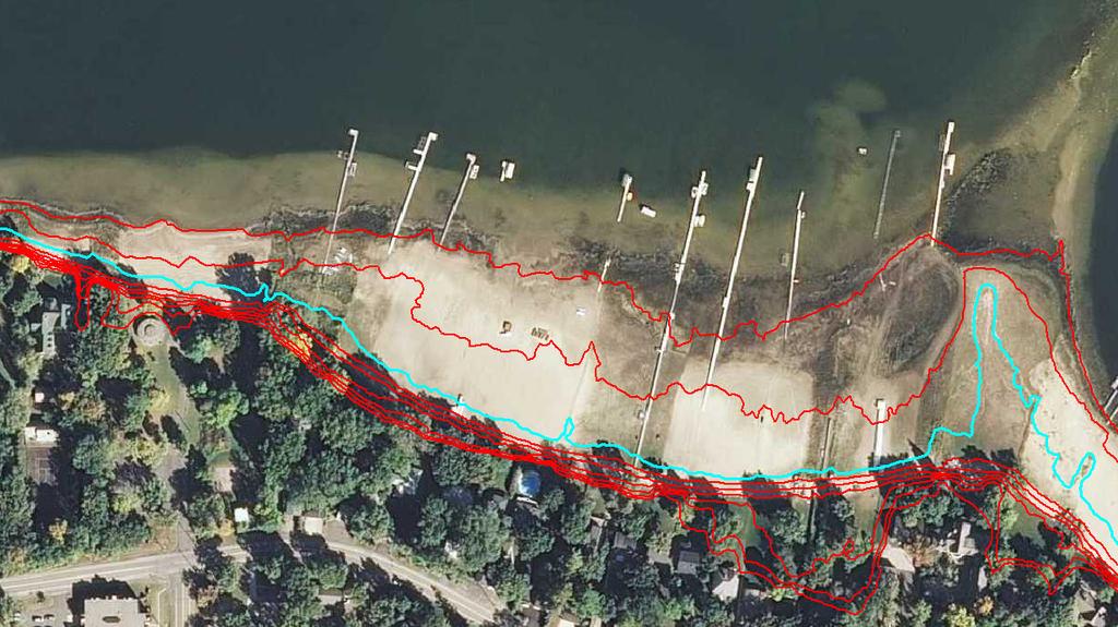
7 Highlighted contour 923 Ramsey County Beach boat ramp June 8,


")
8 Ramsey County Beach boat ramp 924 median lake level Elevation (feet) bottom - concrete ramp lowest recorded lake level Distance (feet) June 8,
9 Ramsey County Beach (adjacent park building) Elevation (feet) median lake level lowest recorded lake level Distance (feet) Acres of Treatment Acres of permitted Eurasion Water Millfoil treatment ( DNR permit records) Lake Level Data (ft above MSL) June 8,
 WBL Marinas 9/2008 (921.")
 Tally's Docks of White Bear")
10 WBL Marinas 4/2004 (923.5 ) WBL Marinas 9/2008 (921.5 ) VFW dock White Bear Boat Works (City) Tally's Docks of White Bear Lake June 8,
 WBL outlet near Ramsey County")

11 WBL Marinas 4/2016? (922.0 ) WBL outlet near Ramsey County Beach Culvert inverts authorized elevation: Constructed at June 8,
12 Summary of Technical Analysis Water levels -frequency analysis of historical record Above 923 about 58% Above 922 about 73% Above 921 about 90% Lowest recorded in January 2013 Ordinary High Water (OHW) Level ' Lake outlet 924.3' Emergent aquatic vegetation needs periodic lower levels to regenerate (between elevation ) Fish habitat has benefited from diverse aquatic vegetation, especially nearshore emergent and floating leaf types Water quality and clarity not substantially related to water elevation Recreation Dock extensions when below 923 Navigation impacts (esp. sailing) below ~921.5 Ramsey Cty Swimming beach closed ~921 Bellaire and Mahtomedi beaches remained open Boat access compromised below 920 Questions? Contact: Jason Moeckel, Manager Inventory, Monitoring, and Analysis Section MN DNR jason.moeckel@state.mn.us Phone: June 8,
13 3000 Groundwater use White Bear Lake area (2-mile buffer) Prairie du Chien-Jordan* and Jordan aquifers, Vadnais Heights, White Bear Township, White Bear Lake, and Mahtomedi area Water Use, millions of gallons PDCJ* Year Jordan Total June 8,
Eurasian Watermilfoil Management Program and Water Quality Summary for White Bear Lake, Washington County, Minnesota, 2018
 Ramsey County Beach, White Bear Lake, June 4, 2018 Eurasian Watermilfoil Management Program and Water Quality Summary for White Bear Lake, Washington County, Minnesota, 2018 EWM Delineation Conducted on
Restoring a More Natural Flow Regime to the Clinton River Watershed. MWEA 87 th Annual Conference June 26, 2012
 Restoring a More Natural Flow Regime to the Clinton River Watershed MWEA 87 th Annual Conference June 26, 2012 Donald D. Carpenter, Ph.D., PE, LEED AP Lawrence Technological University Agenda Study Goals
NORTH FORK FEATHER RIVER, CA
 Hydropower Project License Summary NORTH FORK FEATHER RIVER, CA ROCK CREEK CRESTA HYDROELECTRIC PROJECT (P-1962) Kayakers below the Cresta Dam Photo: Hydropower Reform Coalition This summary was produced
SPOTTED BEAR RIVER PROJECT REVISED ENVIRONMENTAL ASSESSMENT
 SPOTTED BEAR RIVER PROJECT REVISED ENVIRONMENTAL ASSESSMENT TABLE OF CONTENTS CHAPTER 1 PURPOSE AND NEED I. INTRODUCTION.. 1-1 II. PROJECT AREA....... 1-2 III. PURPOSE AND NEED.. 1-2 IV. PROJECT SCOPE.....
Updates to the MODFLOW Groundwater Model of the San Antonio Segment of the Edwards Aquifer
 Updates to the MODFLOW Groundwater Model of the San Antonio Segment of the Edwards Aquifer Presented by Jim Winterle November 14, 2017 EAA Modeling Team: Angang Al Liu Ned Troshanov Andi Zhang Jim Winterle
Prepared for Friends of the Corte Madera Creek Watershed. By Ross Taylor and Associates
 CATALOG OF STREAM CROSSINGS WITH CULVERTS AND OTHER MANMADE IMPEDIMENTS TO FISH PASSAGE LOCATED ON ANADROMOUS STREAM REACHES WITHIN FAIRFAX CREEK, CORTE MADERA CREEK WATERSHED, MARIN COUNTY, CA. Prepared
If you have questions or need additional information, please contact us. Attachment: Prior Lake Outlet Annual Operations Report, Year 2008
 January 16, 2009 Ms. Janell Miersch, Area Hydrologist Metro Region of Waters Department of Natural Resources 1200 Warner Road St. Paul, Minnesota 55106 Prior Lake Outlet Annual Operations Report, Year
Overview of State and Federal Water Law. Jennifer Gimbel Colorado Water Institute
 Overview of State and Federal Water Law Jennifer Gimbel Colorado Water Institute Mormons establish large irrigated network. By 1865, Mormons had dug 1,000 miles of canals in Utah. 1859 Gold Rush in the
RTKC- East Abutment Extension Individual Permit Application November 15, Figure 1. East Abutment Extension General Vicinity Map
 RTKC- East Abutment Extension November 15, 2016 2.1. Figure 1. East Abutment Extension General Vicinity Map WP NATURAL RESOURCE CONSULTING, INC. 4 RTKC- East Abutment Extension November 15, 2016 2.2. Figure
Table of Contents. Introductory Command Message & Foreword Table of Contents
 EP 310-1-6a Introduction Section 1 Introduction Section 2 Principles and Guidelines Section 3 Program Plan and Documentation Section 4 Design Standards Section 5 Identification Signs Introductory Command
Hard Hat Services ph: hardhatinc.com 932 N. Wright St., Suite 160 Naperville, IL 60563
 Interstate Power and Light Company Burlington Generation Station CCR Surface Impoundment Annual Inspection Report 154.018.012.001 Report issued: December 21, 2016 Hard Hat Services ph: 877-630-7428 hardhatinc.com
Adam D. James, P.E., CFM Eric Y. Chow, P.E., CFM. NRCS DAM RISK ASSESSMENTS Sites 6 and 8 Eddy and Chaves Counties, New Mexico
 Adam D. James, P.E., CFM Eric Y. Chow, P.E., CFM NRCS DAM RISK ASSESSMENTS Sites 6 and 8 Eddy and Chaves Counties, New Mexico Cottonwood Walnut Creek watershed, drains east to the Pecos River Purpose to
Chief Executive Officer Opportunity. Sanibel-Captiva Conservation Foundation, Inc. Sanibel, Florida
 Chief Executive Officer Opportunity Sanibel-Captiva Conservation Foundation, Inc. Sanibel, Florida Candidate Submission Deadline: April 15, 2018 Mission Sanibel-Captiva Conservation Foundation, Inc. (
Lake George Asian Clam Post-Treatment Survey
 Lake George Asian Clam Post-Treatment Survey Submitted by Sandra Nierzwicki Bauer & Jeremy Farrell, Darrin Fresh Water Institute (Rensselaer Polytechnic Institute), Bolton Landing, NY Steven C. Resler,
Welcome. Recreational Enhancements on the Lehigh River Public Information Workshop 31 January 2008
 Welcome Recreational Enhancements on the Lehigh River Public Information Workshop 31 January 2008 Cooperating Agencies US Army Corps of Engineers Philadelphia District Delaware River Basin Commission Pennsylvania
Mean Absolute Deviation (MAD) Statistics 7.SP.3, 7.SP.4
 Statistics 7.SP.3, 7.SP.4") Mean Absolute Deviation (MAD) Statistics 7.SP.3, 7.SP.4 Review Let s Begin The Mean Absolute Deviation (MAD) of a set of data. is the average distance between each data value and the mean. 1. Find the
Mean Absolute Deviation (MAD) Statistics 7.SP.3, 7.SP.4 Review Let s Begin The Mean Absolute Deviation (MAD) of a set of data. is the average distance between each data value and the mean. 1. Find the
PEAK FLOW REDUCTION OPPORTUNITIES IN THE CASCADE CREEK TRIBUTARIES. Final Report. Olmsted County, MN November 2008 Project Number:
 PEAK FLOW REDUCTION OPPORTUNITIES IN THE CASCADE CREEK TRIBUTARIES Final Report Olmsted County, MN November 28 Project Number: 362-614 COUNTY OF OLMSTED PEAK FLOW REDUCTION OPPORTUNITIES IN THE CASCADE
Doug Leeper, Senior Environmental Scientist Resource Conservation and Development Department Southwest Florida Water Management District
 February 4, 2003 MEMORANDUM TO: File FROM: Doug Leeper, Senior Environmental Scientist Resource Conservation and Development Department Southwest Florida Water Management District SUBJECT: Proposed minimum
Dissolved Oxygen Study Report
 Dissolved Oxygen Study Report Richland Creek McCabe Park Nashville, Tennessee WATER QUALITY MONITORING PROGRAM 2011 Prepared August 2012 by Monette Rebecca, Executive Director World Wildlife Fund and Tennessee
The key points of the NPA s submission on the draft management plan are:
 The Senior Planning Officer Environment and Recreation Parks, Conservation and Lands PO Box 352 CIVIC SQUARE ACT 2608 JERRABOMBERRA WETLANDS NATURE RESERVE The National Parks Association of the ACT (NPA)
FEASIBILITY REPORT ENVIRONMENTAL IMPACT STATEMENT COASTAL STORM DAMAGE REDUCTION PROJECT
 FEASIBILITY REPORT AND ENVIRONMENTAL IMPACT STATEMENT COASTAL STORM DAMAGE REDUCTION PROJECT SURF CITY AND NORTH TOPSAIL BEACH NORTH CAROLINA Appendix E Sand Compatibility Analysis Appendix E: Sand Compatibility
Part 3.2 Protection of Natural, Environmental, Economic and Scenic Resources
 3.2.1. CZP 3-19-12 Part 3.2 Protection of Natural, Environmental, Economic and Scenic Resources The preservation and conservation of resources is a key component of the Sanibel Plan and its Vision Statement
Guide to Public Participation. Addressing: Hearing Examiner Process
 Guide to Public Participation Addressing: Hearing Examiner Process COVER LAST REVISED 7/25/2014 GUIDE TO PUBLIC PARTICIPATION BEFORE THE HEARING EXAMINER FOR SPECIAL EXCEPTIONS, VARIANCES, AND REZONINGS
Jim Woodruff Dam Section 7 Consultation. Hydrological Modeling Technical Workshop II 12 July 2006
 Jim Woodruff Dam Section 7 Consultation Hydrological Modeling Technical Workshop II 12 July 2006 Endangered Species Act of 1973 Section 7 Consultation All Federal agencies shall, in consultation with and
Attachment E, Exhibit 1 Los Vaqueros Reservoir Recreation Model
 Attachment E, Exhibit 1 Los Vaqueros Reservoir Recreation Model Proposition 1 February 2018 This page is intentionally left blank. LOS VAQUEROS RESERVOIR EXISTING DAY-USE FACILITIES Parking Equestrian/
10. TRACE ELEMENTS Introduction. Trace Elements Bristol Bay Drainages
 10. TRACE ELEMENTS 10.1 Introduction The trace element studies in the Bristol Bay drainages study areas were conducted to acquire baseline data on naturally occurring constituents in upland soil, terrestrial
Environmental Chemistry Unit C
 Environmental Chemistry Unit C Topic 1 Topic 2 Topic 3 Topic 4 Topic 5 Topic 6 A Hair Raising Dilemma Take Two Pebbles A Balanced Approach The Root Source Commercial Fertilizers Issues Emerging From High
Canal Current. Environmental News. Native Plant profile. July is National Parks and Recreation Month
 Canal Current A wave of information for Cape Coral s Canalwatch volunteers Newsletter: 2 nd Quarter 2010 Environmental News July is National Parks and Recreation Month In recognition of the National Parks
Benton County Listening Tour
 Benton County Listening Tour Commercial Marijuana & Zoning Regulations Photo Right: http://www.fastcoexist.com/3038209/visualizing/marijuana-is-the-worlds-most-lucrative-cash-crop 1 Timeline 1998 Medical
Cannabis Regulations for Sonoma County Jurisdictions as of March 26, 2018
 Jurisdiction County Status License Type: Use Permit Limits on Number of Dispensaries: 9 Limits on Dispensary Size: 1000 sq. ft. Zoning: A medical cannabis dispensary proposed within the sphere of influence
CR5 Stream Reach Summary
 CR5 Stream Reach Summary Study Reach: CR5, Colorado River - Williams Fork confluence downstream to the KB Ditch. Reach Description: Approximate channel length: 6.75 miles, approximate channel slope 0.3%.
Urban Drainage and Flood Control District. Goldsmith Iliff Pond E-19 Survey
 Urban Drainage and Flood Control District Goldsmith Gulch @ Iliff Pond E-19 Survey GOLDSMITH GULCH @ ILIFF ALERT ID: 653/654 LID: ILFC2 Prepared by: HDR Engineering, Inc. 303 E 17 th Ave. Suite 700 Denver
FORT WORTH DISTRICT. I-30/SH 360 Interchange Project. Castillian Condominiums Noise Workshop #2
 FORT WORTH DISTRICT I-30/SH 360 Interchange Project Castillian Condominiums Noise Workshop #2 City of Grand Prairie, Tarrant County, Texas December 21, 2017 Photo by Liam Frederick CSJs: 1068-02-076, -104,
PRESIDENT S MESSAGE Mimi Zwolak
 PRESIDENT S MESSAGE Mimi Zwolak Welcome spring! Thank you for your membership to Missaukee Lake Association! We have a common bond in our love for Lake Missaukee, a wonderful and vibrant body of water
Citizen Advisory Commission (CAC): Raingarden Chamberlain: See CAC description and application on separate form.
: Raingarden Chamberlain: See CAC description and application on separate form.") 2019 Watershed Action Volunteer (WAV) Positions VLAWMO requests volunteers to hold positions for the time outlined in each position description. Volunteers may renew their role upon completion of the outlined
2019 Watershed Action Volunteer (WAV) Positions VLAWMO requests volunteers to hold positions for the time outlined in each position description. Volunteers may renew their role upon completion of the outlined
WATER LEVEL. Measurements. A publication of the High Plains Underground Water Conservation District
 LEVEL WATER Measurements 2017 A publication of the High Plains Underground Water Conservation District In this issue: Jason Coleman, P. E. Results of the 2017 water level measurements are included in this
Department of Psychology
 Department of Psychology Who Grows a Natural Shoreline and Who Doesn t? Antecedents of Behavior on Wisconsin s Shorelands Michael S. Amato PhD Candidate Psychology and Environment & Resources UNIVERSITY
Lessons learned in multi-objective urban detention basin projects
 Lessons learned in multi-objective urban detention basin projects Raymond Wong, PhD, PE, LEED AP Patrick Sullivan, PE Bill Silva, PE Floodplain Management Association Conference September 6, 2017 Urban
DRAFT County Registration Form Medical Cannabis Cultivation and Future Non-Medical Cannabis Cultivation and Related Operations
 Introduction ATTACHMENT 2B DRAFT County Registration Form Medical Cannabis Cultivation and Future Non-Medical Cannabis Cultivation and Related Operations If you are growing cannabis under the personal
St. Croix River Crossing Bridge Foundation Load Test Project. 1/27/2010 St. Croix River Crossing Bridge - Foundation Load Test Project
 St. Croix River Crossing Bridge Foundation Load Test Project Load Test Sites 4 driven piles Drilled Shaft Site A Site B Load Test Purpose To gather design data for foundation design Allows for more refined
Public Hearing Summary Report
 Public Hearing Summary Report FM 457 Swingbridge Replacement At Gulf Intracoastal Waterway (GIWW) near Sargent FM 457 Matagorda Co CSJ: 0605-01-060 Alan Migl, Yoakum District TABLE OF CONTENTS Public Hearing
Common Guidance for the Interpretation & Identification of High Conservation Values. 1 July, 2013 Santiago
 Common Guidance for the Interpretation & Identification of High Conservation Values 1 July, 2013 Santiago HCV Common Guidance Update on P9 and Common Guidance Key considerations for interpretation The
Commercial Redevelopment Study
 Commercial Redevelopment Study Impact on Sanibel of Immediate Off-Island Development January 22, 2013 Commercial Redevelopment Study To date, Council has approved a vision statement and identified Sanibel
CADDO LEVEE DISTRICT
 CADDO LEVEE DISTRICT 1320 Grimmett Dr. Shreveport, LA 71107 www.caddolevee.org Phone: (318) 221-2654 2015 ANNUAL REPORT ADMINISTRATOR S LETTER Working for Caddo Levee District and serving the residents
Repairing the Pecos River at Bitter Lake National Wildlife Refuge
 Repairing the Pecos River at Bitter Lake National Wildlife Refuge Photo: Ken Stinnett New Mexico Watershed Forum, 2010 Conference Paul Tashjian; Stephen Davenport; Jeff Sanchez US Fish and Wildlife Service
years later the time has come to decide what vegetation should be planted. Because the City of Berkeley
 Chapter 4 SOIL ANALYSIS OF THE BERKELEY NORTH WATERFRONT PARK Rumall Randhawa In 1983 the Berkeley City Dump was closed, and the process of creating the North Waterfront Park began. A landscape architect
NJ Department of Environmental Protection Water Monitoring and Standards Bureau of Marine Water Monitoring. Money Island / Gandy s Beach Impact Study
 NJ Department of Environmental Protection Water Monitoring and Standards Bureau of Marine Water Monitoring Money Island / Gandy s Beach Impact Study August 2014 Money Island / Gandy s Beach Impact Study
Student Pages: Group Activity
 Student Pages: Group Activity Grizzly Bear Science Team 2 For this activity, your group is the "Grizzly Bear Science Team #2". Your team is responsible for scientifically evaluating whether or not the
Cannabis Land Use Ordinance Draft Environmental Impact Report Public Briefing
 Cannabis Land Use Ordinance Draft Environmental Impact Report Public Briefing Kern County Board of Supervisors August 22, 2017 Lorelei H. Oviatt, AICP Director Kern County Planning and Natural Resources
Sage Grouse Habitat Restoration Progress in Elko, County Nevada. Chris M. Jasmine Partners for Fish and Wildlife Program NE Nevada Coordinator
 Sage Grouse Habitat Restoration Progress in Elko, County Nevada Chris M. Jasmine Partners for Fish and Wildlife Program NE Nevada Coordinator Sage Grouse Habitat Restoration Progress in Elko, County Nevada
HUMAN HEALTH AND ECOLOGICAL ASSESSMENT OF THE SIOUX ENERGY CENTER
 www.haleyaldrich.com REPORT ON HUMAN HEALTH AND ECOLOGICAL ASSESSMENT OF THE SIOUX ENERGY CENTER AMEREN MISSOURI ST. LOUIS, MISSOURI by Haley & Aldrich, Inc. Boston, Massachusetts for Ameren Missouri St.
ORDINANCE NUMBER 2381
 Ordinance Number 2381 Page 1 ORDINANCE NUMBER 2381 AN ORDINANCE TO FURTHER AMEND THE ZONING ORDINANCE AND THE ZONING MAP OF THE CITY OF VESTAVIA HILLS, ALABAMA, ADOPTED SEPTEMBER 16, 1985, AND AS LAST
DNR Watershed Priorities for the Zumbro River Watershed
 DNR Watershed Priorities for the Zumbro Watershed This document was prepared by efforts led by the Department of Natural Resources (DNR), Division of Ecological and Water Resources (EWR). Region 3 staff
12220 Fillmore Street, Room 331, West Olive, Michigan (616)
") County of Ottawa Administrator s Office Alan G. Vanderberg County Administrator 12220 Fillmore Street, Room 331, West Olive, Michigan 49460 (616) 738-4068 e-mail: avanderberg@miottawa.org County Administrator
County of Ottawa Administrator s Office Alan G. Vanderberg County Administrator 12220 Fillmore Street, Room 331, West Olive, Michigan 49460 (616) 738-4068 e-mail: avanderberg@miottawa.org County Administrator
OREGON SAGE GROUSE FRAMEWORK
 OREGON SAGE GROUSE FRAMEWORK Protecting sage grouse habitat from human disturbance 1. Existing Conditions Oregon has effectively protected Greater Sage Grouse core habitat from most human disturbance.
IRon chlorosis. on tuq~ CjQasses oqnamentals vecjetables - L-435
 C1 4 1~75 - L-435 IRon chlorosis on tuq~ CjQasses oqnamentals vecjetables Texas Agricultural Extension Service The Texas A&M University System John E. Hutchison, Director, College Station, Texas IRON CHLOROSIS
Autecology of Scarlet Gaura on the Northern Mixed Grass Prairie
 Autecology of Scarlet Gaura on the Northern Mixed Grass Prairie Llewellyn L. Manske PhD Research Professor of Range Science North Dakota State University Dickinson Research Extension Center Report DREC
Fig Draw a food chain for the organisms in the passages above. Table 6.1
 1 Moose, Alces americanus, shown in Fig. 6.1, are large herbivores that primarily live in northern parts of North America. They have a varied diet that includes young shoots of willow trees and aquatic
2350 Whitesburg Drive Huntsville, AL 35801
 , Huntsville HSV - Office / Med Bldg Great Corner Location Beautiful Building with Multi Uses Ample Parking Beautifully Landscaped Near Hospital dmc@chasecommercial.com AL #000033300-0 No warranty, express
Bridge Office Trunk Highway Bridge Flood Response Plan
 Bridge Office Trunk Highway Bridge Flood Response Plan Updated 7/18/2012 Purpose Bridges are vulnerable to damage and failure during flooding. Scour may undermine the bridge foundations or remove the protection
ADA Signage Guidelines
 OVERVIEW The Department of Justice published revised regulations for Titles II and III of the Americans with Disabilities Act of 1990 in the Federal Register on September 15, 2010. The regulations adopted
MULTIPLE CHOICE. Choose the one alternative that best completes the statement or answers the question.
 Statistics Final Review Semeter I Name MULTIPLE CHOICE. Choose the one alternative that best completes the statement or answers the question. Provide an appropriate response. 1) The Centers for Disease
Three Bridges at I-64/Mercury Boulevard Interchange in Hampton, VA
 Three Bridges at I-64/Mercury Boulevard Interchange in Hampton, VA IRFAN A. ALVI, P.E., Alvi Associates, Inc., Baltimore, MD IBC-02-25 KEYWORDS: box girder, counterweight abutment, curved girder, high-performance
Minnesota Department of Agriculture s Nitrate Testing Clinic Program 2011 Results Summary
 Minnesota Department of Agriculture s Nitrate Testing Clinic Program 2011 Results Summary January 2012 Kimberly Kaiser Thomas Bolas In accordance with the Americans with Disabilities Act, an alternative
RE: Proliferation of Marijuana Grow Operations in Garfield County Regulation of Marijuana Personal Use, Medical Use, and Caregivers in Garfield County
 RE: Proliferation of Marijuana Grow Operations in Garfield County Regulation of Marijuana Personal Use, Medical Use, and Caregivers in Garfield County Board of County Commissioners Direction On July 18,
Exponential Decay. Lesson2
 Lesson2 Exponential Decay In 1989, the oil tanker Exxon Valdez ran aground in waters near the Kenai peninsula of Alaska. Over 10 million gallons of oil spread on the waters and shoreline of the area, endangering
The West Indian Manatee- A Study in Evolutionary Patterns
 The West Indian Manatee- A Study in Evolutionary Patterns Purpose To study three animals as examples of convergent and divergent evolution Name Objective Identify similarities and differences between the
Benchmark Report Business Operations Bureau
 Benchmark Report Business Operations Bureau November 2011 Riverside County Regional Park and Open-Space District Riverside, California Benchmarking Analysis Benchmarking Analysis is an important element
FOR LEASE WAREHOUSE/OFFICE. Prepared By. 855 Stanton Road Burlingame, CA 94010
 855 Stanton Road Burlingame, CA 94010 WAREHOUSE/OFFICE Approx. 10,100 Sq. Ft. Total Rentable Area 8,900 Warehouse Open Design Approx. with 1,200 Sq. Ft. Office Space Approx. Dock - High Loading Front and
Recreational Marijuana Town of Mammoth Lakes Proposed implementation of Prop 64 April 26, 2017
 Recreational Marijuana Town of Mammoth Lakes Proposed implementation of Prop 64 April 26, 2017 Workshop summary Personal Use Taxation State licensing requirements for marijuana sales Current Town regulations
Lake Zumbro Restoration Project Timeline (Draft) Prepared by Terry Lee, Olmsted Water Resources Manager June 25, 2015
 Prepared by Terry Lee, Olmsted Water Resources Manager June 25, 2015") Lake Zumbro Restoration Project Timeline 2005-2015 (Draft) Prepared by Terry Lee, Olmsted Water Resources Manager June 25, 2015 2005 3/31/05 Lake Zumbro Improvement Association appointed a Lake Restoration
Lake Zumbro Restoration Project Timeline 2005-2015 (Draft) Prepared by Terry Lee, Olmsted Water Resources Manager June 25, 2015 2005 3/31/05 Lake Zumbro Improvement Association appointed a Lake Restoration
DRAINAGE ANALYSIS REPORT
 DRAINAGE ANALYSIS REPORT FOR The Village at Barnstable (Phase ) Active Adult Apartments Located at: Communication Way Hyannis, Massachusetts Prepared for: Greystar Group II, LLC, LLC Greensboro Drive Suite
DULLES CONNCECTOR ROAD SOUND WALL PROJECT FUNDAMENTALS OF TRAFFIC NOISE AND RESULTS. Paul M. Kohler Noise Abatement Program Manager
 DULLES CONNCECTOR ROAD SOUND WALL PROJECT FUNDAMENTALS OF TRAFFIC NOISE AND RESULTS Paul M. Kohler Noise Abatement Program Manager WHAT IS NOISE? Noise is unwanted sound. It is perceived differently by
LEAF Marque. Standard Setting. Public System Report
 LEAF Marque Standard Setting Public System Report LEAF (Linking Environment And Farming) is a charity whose objectives are to promote and improve agriculture, horticulture and other types of farming and
Table 3-1 Summary of Storm Drain Outfalls
 Table 3-1 Summary of Storm Drain Outfalls Outfall Number Description 005 The drainage area associated with Outfall 005 is to the west of the plant adjacent to and north of Warehouse 2/3, and includes a
Dittamo & Lewis 6th Grade CRCT 2013 Review
 Dittamo & Lewis 6th Grade CRCT 2013 Review Which list shows the numbers in ascending order? A.) 3.5, 3.25, 3.75 B.) 3.25, 3.5, 3.75 C.) 3.5, 3.75, 3.25 D.) 3.25, 3.5, 3.75 What are two ways to put these
Responses from State and Local Agencies
 Responses from State and Local Agencies Based on the proposed Constitutional Amendment for the 2016 Ballot A document presented at the September 30, 2015 FIEC by Drug Free America/Save our Society from
Status of Implementation of Approved Rehabilitation Plans: ARA Sites in Halton Region ( )
") ttachment #5 to LPS96-15 Status of Implementation of pproved Rehabilitation Plans: R Sites in Halton Region (2012-2014) Site Name, R Rehabilitation/End-use Description Status of Implementation of pproved
ttachment #5 to LPS96-15 Status of Implementation of pproved Rehabilitation Plans: R Sites in Halton Region (2012-2014) Site Name, R Rehabilitation/End-use Description Status of Implementation of pproved
Scott Miller, PE Engineering Supervisor Washtenaw County Water Resources Commissioner s Office
 Scott Miller, PE Engineering Supervisor Washtenaw County Water Resources Commissioner s Office BS Civil and Env. Engineering University of Toledo MS Env. And Water Resources Engineering University of Michigan
VAIL LAKE RESORT - 7,955 ACRES - TRUSTEE SALE / STALKING HORSE BID
 ANTICIPATED MINIMUM OVERBID OF APPROX $33,000,000 Includes Vail Lake Membership Rights 520 Full Hook-up RV Sites, Miniature Golf, Swimming, Boating, Fishing, Water Slides, Bar and Other Amenities 7 Miles
A COLLABORATIVE NATIONAL STRATEGY TO MANAGE FERAL SWINE IMPACTS IN THE U.S.
 A COLLABORATIVE NATIONAL STRATEGY TO MANAGE FERAL SWINE IMPACTS IN THE U.S. Restore America s Estuaries Summit Invasive Species Workshop December 15, 2016 USDA APHIS National Feral Swine Program Wendy
Bay Lake Improvement Association Annual Meeting Minutes 9:30 A.M., Saturday July 15, 2007 Ruttger s Bay Lake Lodge
 Bay Lake Improvement Association Annual Meeting Minutes 9:30 A.M., Saturday July 15, 2007 Ruttger s Bay Lake Lodge Officers/Directors Present Committee Chairs Present Jespersen, Patricia President Albertson,
F-VC Stream Reach Summary
 F-VC Stream Reach Summary Study Reach: F-VC, Vasquez Creek - Denver Water Diversion downstream to confluence of Fraser River. Reach Description: Approximate channel length: 5 ½ miles with an average channel
Ground Sampling Standards
 Ground Sampling Standards MINISTRY OF FORESTS RESOURCES INVENTORY BRANCH JULY 1997 Table of Contents GROUND SAMPLING STANDARDS...1 INTRODUCTION...1 MEASUREMENT OF ATTRIBUTES...2 Continuous Attributes...2
FINAL COVER SYSTEM SURFACE WATER MANAGEMENT SYSTEM DESIGN
 DRAFT ONONDAGA LAKE SEDIMENT CONSOLIDATION AREA CIVIL & GEOTECHNICAL FINAL DESIGN BBAPPENDIX K. FINAL COVER SYSTEM SURFACE WATER MANAGEMENT SYSTEM DESIGN p:\honeywell -syr\ - lake detail design\ reports\.
Recreational Marijuana in Clark County, Washington
 in Clark County, Washington Alaska Municipal League Gordy Euler, Ph.D, AICP Community Planning, Clark County, Washington Oliver Orjiako, Director Community Planning Purpose Present what Clark County did
Student Pages: Group Activity
 Student Pages: Group Activity Grizzly Bear Science Team 2 For this activity, your group is the "Grizzly Bear Science Team #2". Your team is responsible for scientifically evaluating whether or not the
ZONING COMPLIANCE REVIEW HEMP (ZCRH)
") ZONING COMPLIANCE REVIEW HEMP (ZCRH) FEMALE HEMP MALE/HERMAPHRODITE HEMP Hemp Establishment* is only permitted: in the A-1/A-2, Agricultural Zone Districts in a greenhouse, building, or outside farming
ZONING COMPLIANCE REVIEW HEMP (ZCRH) FEMALE HEMP MALE/HERMAPHRODITE HEMP Hemp Establishment* is only permitted: in the A-1/A-2, Agricultural Zone Districts in a greenhouse, building, or outside farming
THERMAL ENERGY STORAGE TANK DOWN UNDER
 THERMAL ENERGY STORAGE TANK DOWN UNDER OWNER ENGINEER TANK BUILDER Thermal Energy Storage Tank Walnut, CA Los Angeles area Community College serving over 50,000 students Host to the 2020 U.S. Olympic Track
Autecology of Purple Coneflower on the Northern Mixed Grass Prairie
 Autecology of Purple Coneflower on the Northern Mixed Grass Prairie Llewellyn L. Manske PhD Research Professor of Range Science North Dakota State University Dickinson Research Extension Center Report
TALLAPOOSA RIVER FLOW ANALYSIS R L HARRIS DAM Downstream to WADLEY GAUGE GEO-TUBES EVALUATION
 TALLAPOOSA RIVER FLOW ANALYSIS R L HARRIS DAM Downstream to WADLEY GAUGE GEO-TUBES EVALUATION November 3, 003 Page of INTRODUCTION This report addresses hydraulic analysis of a fourteen mile section of
School of Community Health Sciences
 National Park Service U.S. Department of the Interior School of Community Health Sciences University of Nevada, Las Vegas (UNLV) Dr. Howard R. D. Gordon E X P E R I E N C E Y O U R A M E R I C A National
Cost of delivery is based on location of delivery and amount of order.
 Albertville 50 20 FREE Andover FREE FREE FREE Anoka FREE FREE FREE Apple Valley 70 40 FREE Arden Hills FREE FREE FREE Becker 70 40 FREE Bethel FREE FREE FREE Big Lake 50 25 FREE Blaine FREE FREE FREE Blomford
AN ORDINANCE OF THE BOARD OF COUNTY
 ORDINANCE NO. - AN ORDINANCE OF THE BOARD OF COUNTY COMMISSIONERS OF MARION COUNTY, FLORIDA, APPROVING AMENDMENTS TO THE MARION COUNTY LAND DEVELOPMENT CODE, ARTICLES 1 (ADMINISTRATION), AND (ZONING);
TECHNICAL ANNEX with country details
 WG ECOSTAT report on common understanding of using mitigation s for reaching Good Ecological Potential for heavily modified water bodies Part 1: Impacted by water storage TECHNICAL ANNEX with country details
Drainage and Detention Report. for. Charity Auto Sales. located at: East 116 th Street North Collinsville, OK Revised August 22, 2016
 Drainage and Detention Report for Charity Auto Sales located at: 9 East 6 th Street North Collinsville, OK 742 Revised August 22, 26 Olsson Associates, Inc. 9 N. Birch Street, Suite 2 Owasso, OK 74 (98)
North Miami-Dade County Retail/Flex Space For Lease First Year Rent Starting at $11.50/SF, Gross
 North Miami-Dade County Retail/Flex Space For Lease First Year Rent Starting at $11.50/SF, Gross Fully Air Conditioned 44,000 SF Retail/Flex Center ± 2,543 Sq. Ft. Showroom/Warehouse Full Glass Window
ORDINANCE NO. An ordinance enacting restrictions on commercial advertising of Cannabis and Cannabis Products on signs.
 ORDINANCE NO. An ordinance enacting restrictions on commercial advertising of Cannabis and Cannabis Products on signs. THE PEOPLE OF THE CITY OF LOS ANGELES DO ORDAIN AS FOLLOWS: Section 1. A new Article
HYDRAULIC MODELING ASSESSMENT OF THE TURNER FALLS IMPOUNDMENT TURNERS FALLS HYDROELECTRIC PROJECT (NO. 1889) AND NORTHFIELD MOUNTAIN PUMPED STORAGE
 AND NORTHFIELD MOUNTAIN PUMPED STORAGE") HYDRAULIC MODELING ASSESSMENT OF THE TURNER FALLS IMPOUNDMENT TURNERS FALLS HYDROELECTRIC PROJECT (NO. 1889) AND NORTHFIELD MOUNTAIN PUMPED STORAGE PROJECT (NO. 2485) FEBRUARY 2013 TABLE OF CONTENTS 1.0
HYDRAULIC MODELING ASSESSMENT OF THE TURNER FALLS IMPOUNDMENT TURNERS FALLS HYDROELECTRIC PROJECT (NO. 1889) AND NORTHFIELD MOUNTAIN PUMPED STORAGE PROJECT (NO. 2485) FEBRUARY 2013 TABLE OF CONTENTS 1.0
on the Lehigh River Public Information Workshop
 Recreational Enhancements on the Lehigh River Public Information Workshop 16 February 2011 Cooperating Agencies US Army Corps of Engineers Philadelphia l District i Delaware River Basin Commission Pennsylvania