Restoring a More Natural Flow Regime to the Clinton River Watershed. MWEA 87 th Annual Conference June 26, 2012
|
|
|
- Robyn Boyd
- 5 years ago
- Views:
Transcription

1 Restoring a More Natural Flow Regime to the Clinton River Watershed MWEA 87 th Annual Conference June 26, 2012 Donald D. Carpenter, Ph.D., PE, LEED AP Lawrence Technological University Agenda Study Goals Clinton River Watershed Current conditions and flow management Stakeholder engagement and survey results Environmental Impacts Recreational Impacts Hydrologic Modeling Socio-economic Modeling Summary 1
 4.")
2 Study Goals 1. Document environmental, social, and economic trends related to current conditions 2. Forecast river/lake conditions under alternative flow management scenarios 3. Solicit public comment (stakeholder engagement) 4. Provide technical guidance on possible means of implementing the various management alternatives 3 Key Project Participants NOAA Michigan Sea Grant 4 2
3 Key Project Participants Environmental Consulting & Technology, Inc Veritas Economic Consulting, LLC Oakland University City of Auburn Hills 5 Technical Advisory Board Oakland County WRC Oakland County PEDS Michigan DNR Michigan DEQ Sylvan Lake Association Oakland Lake Association Clinton River Watershed Council Trout Unlimited City of Auburn Hills City of Rochester Hills City of Rochester Waterford Township Outdoor Escorts LLC Spalding DeDecker Local Business Owners & Citizens 6 3

4 Clinton River Watershed square miles 80 miles from headwaters to the outlet at Lake St. Clair Includes portions of Wayne, Lapeer, Macomb, Oakland & St. Clair counties Includes 63 communities 1.5 million people live within the watershed Most populated watershed in Michigan 8 4
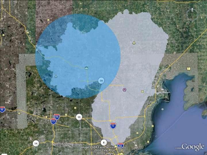
5 10 1 5
6 Current Conditions 1 Process for Establishing Lake Level Controls Part 307 of the Michigan Natural Resources and Environmental Protection Act establishes normal levels Initiated by a riparian owners petition or a county board Requires an impact study Set by the court 1 6
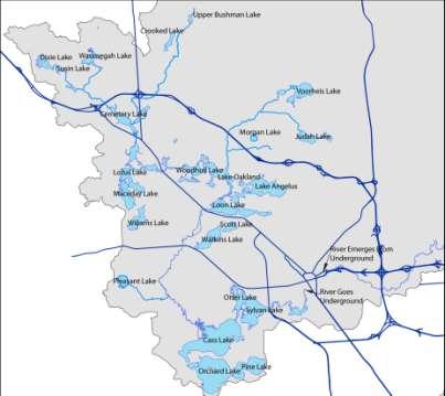
7 Factors Considered when Establishing a Lake Level Protection of public health, safety and welfare Preservation of natural resources of the state Lake and stream habitat Wetlands Preservation and protection of property values around the lake Interaction with surrounding lakes or watershed were not considered in 50s/60s 1 Factors Considered when Establishing a Lake Level 50 lakes/impoundments in the study area 21 with court ordered lake levels 1960 s 8 structures actively managed by OCWRC office: Cemetery-Dollar, Van Norman, Look, Watkins, Orchard, Cass, Dawson Mill, Crystal 1 7

8 Operational Data 1 Consequences of Current Conditions 1 8


9 Issue Interrupted Flow Regime 1 Interactive Map Low Flow Pictures Channel at Paddock and Huron 3 Entrance to Underground Channel 4 5 Exit of Underground Channel 6 Opdyke and Auburn 7 Riverside Park 1 Price Dam 2 Walter Moore Dam


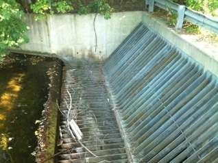
10 Price Dam 1 August 12, 2010 September 1, Entrance to Under Ground Channel 3 August 12, 2010 September 1,


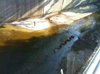
11 Exit from Underground Channel Looking West 4 August 12, 2010 September 1, Exit from Underground Channel Looking East 4 August 12, 2010 September 1,


12 Pontiac WWTP Outfall 2 Opdyke Rd and Auburn Rd 6 September 1,


13 Riverside Park Auburn Hills 7 August 12, 2010 Looking Downstream September 1, 2010 Looking Upstream 2 13
14 14


15 Median Flow - July 17, 2008 No rainfall was recorded from July 15, 2008 to July 19, 2008 The mean flow in the river over five days was 40 cfs (60 cfs in photo) Most control structures were closed or minimally adjusted Lake levels ranged from at court ordered level to 3 inches above Avon Rd Bridge in Rochester Hills - looking downstream (Moore 2008) 3 15

 3 Low Flow - July 6, 2010 No Rainfall from July 4-8, 2010. Mean flow in the river was 18 cfs. All control structures were closed.")
16 High Flow - May 23, year storm 2.72 inches of rain fell over 24 hours Mean flow in the river was 1000 cfs Most control structures were opened to maximum Before the storm lake levels started between 6 below and at court ordered level After the storm lake levels rose to above the court ordered level (approximately 2 ft) Avon Rd Bridge in Rochester Hills Upstream (Moore 2004) 3 Low Flow - July 6, 2010 No Rainfall from July 4-8, Mean flow in the river was 18 cfs. All control structures were closed. Lake levels ranged from 2 inches below to 2 inches above their court ordered levels. Avon Rd Bridge in Rochester Hills looking downstream (Moore 2010) 3 16

17 Flow in Clinton River Closed to maintain lake levels Rainfall remain closed 3 Frequency of Modification Year Consecutive Days of Flow < 30 CFS Consecutive Days of Flow < 20 CFS , July August None , July 51, July September 9, September 2003 No data No data , April 27, September October , August 23, August September 9, October 9, October 23, August September None None Every other year 30 days < 30 cfs and , August None 8, September , June 14 days < 20 None cfs 37, June August 10, August 9, September 18, September 9, October , July August 13, August September 2009 None None , June July 41, August September 10, September , July None 8, August 8, August September 7, July 35, August September 9, September 3 17
18 Stakeholder Engagement 3 Stakeholder Engagement Print Media (Fall of 2010) Oakland Lakefront Magazine, Detroit Free Press, West Oakland Spinal Column, Press Release List serves through Advisory Board contacts Stakeholder Survey 16 questions designed to help project team understand how the stakeholders interact, understand, and use the Clinton River and the connecting lakes (hard copy at forum and online version). Fall 2010 Public Forums: Waterford Township (Nov 3), Auburn Hills (Nov 4), and Oakland University (Nov 13) Approximately 170 people attended three public meetings (89 surveys) 59 surveys were completed online around the same time (138 total) 18
.")
19 Stakeholder Engagement OCWRC office correspondence: sent mailers in 2010 to Lake Improvement Boards to encourage citizen and community leaders to attend public forums. project information sheet with survey information was mailed to each lake improvement board member in spring 2011 (12 Boards and 93 members). Summer 2011 Events (100s of flyers distributed): Clinton River Water Festival, Oakland University, Auburn Hills. Auburn Hills Fishing Derby, Riverside Park, Auburn Hills. CRWC River Fest Rochester Municipal Park, Rochester. Total of 10 online surveys were completed during 2011 Total of 148 Responses Survey Results Lake and River Region 3 19


20 Survey Results Survey Responses from Each ZIP Code 3 I Live: 4 20

21 My Residence is: 4 I believe the lake levels are maintained properly: 4 21

22 Lake Level Fluctuation Please indicate your level of agreement with the following statement: "I would tolerate moderate fluctuation in lake levels if it meant an overall healthier watershed." 4 Lake Level Fluctuation How much fluctuation are you willing to tolerate on your lake for an overall healthier watershed: 4 22


23 Environmental Impacts 4 Environmental Impacts Improve flow and water quality in the river Reduced shoreline erosion Improved aquatic and riparian vegetative communities (native over invasive) 4 23


24 Environmental Impacts Increase in macro-invertabrate communities Improved amphibian populations Improved spawning habitat Improved fishing in river & lakes Improved wildlife viewing 4 Environmental Impacts Improve flow and water quality in the river Reduced shoreline erosion Improved aquatic and riparian vegetative communities Improved amphibian populations Increase in macro-invertabrate communities Improved spawning habitat Improved fishing in river & lakes Improved wildlife viewing 4 24

25 Recreational Impacts 4 Recreational Impacts Fishing Boating Canoeing/kayaking Park Visits 5 25
26 Paddlepalozza and Rental Operations If flow < 50 cfs only 10 miles of 20 miles can be paddled. 26

27 Hydrologic Modeling 5 Hydrologic Model 50 Lakes over a 69,520 acre watershed GIS was used to assign watershed properties Travel time of 32 hours from farthest upstream lake to outlet 5 27
28 Hydrologic Model There were two basic types of scenarios modeled: Rainfall - The response of the watershed to rainfall events and hypothetical management strategies in response to those events Release - A release of water stored in lakes over a set period of time to supplement the Clinton River with flow during times of low water/drought. 5 Rainfall Results Rapid release of water from rainfall events creates high peak flows and flashiness in the river compared with natural flow. Delaying the release of rainfall events of 2 or less could reduce the peak flow in the Clinton River by 15% to 20%. Steadily releasing volume of rain over the watershed over a two week period could create a base flow for the river. 5 28


29 Water Release Results 5 Water Release Results 5 29
30 Water Release Results 2 week Release Scenario Peak Flow (CFS) River Depth at Riverside Park, Auburn Hills (ft) 1 All lakes 2 Inches 42 cfs 1.3 ft Crystal, Cass, Orchard, and Oakland - 2 Inches Crystal - 27 Inches Orchard - 9 Inches Oakland - 6 Inches Cass - 3 inches 15 cfs 1.0 ft 49 cfs 1.4 ft Crystal - 27 Inches 8 cfs 0.9 ft 1 Depth at riverside Park includes 12 cfs from WWTP 5 Water Release Results 30 day Release Scenario Peak Flow (CFS) River Depth at Riverside Park, Auburn Hills (ft) 1 All lakes 2 Inches 20 cfs 1.0 ft Crystal, Cass, Orchard, and Oakland - 2 Inches Crystal - 27 Inches Orchard - 9 Inches Oakland - 6 Inches Cass - 3 inches 7 cfs 0.9 ft 23 cfs 1.1 ft Crystal - 27 Inches 4 cfs 0.8 ft 1 Depth at riverside Park includes 12 cfs from WWTP 6 30
31 Socio-Economic Model 6 Socio-Economic Analysis Management options change watershed interactions, flow, temperature, and channel morphology Clinton River watershed provides valuable services to commercial interests and residents Watershed management affects the economic and social welfare of the region Implication of stakeholder engagement was that flow management strategies that led to large, widespread, and frequent fluctuations were deemed unacceptable 6 31
32 Socio-Economic Analysis Conducted with Spatial Site Choice Model A travel cost-based behavioral modeling technique Applied to a population of sites and people Change site usage with specific resource characteristic (ex: fishing, paddling) 6 Socio-Economic Analysis Usage: Transportation Modeling Natural Resources Damage Assessment Regulatory Impact Analysis Risk Assessment Recreation Planning and Resource Management Boating, paddling, site visits to parks, fishing, etc. 6 32
33 Socio-Economic Findings No significant adverse effects to lake recreators or property owners from modification scenarios considered Increase in water flow provides more opportunities in Clinton River especially during extreme lows Millions of dollars of revenue in usage benefit associated with a more natural flow regime 6 Overall Project Findings Court ordered lake levels are compromising watershed health under current conditions OCWRC office spends significant effort and resources managing a very complex system River flow can be influenced by lake level management (both low flow and high flow) 6 33
34 Overall Project Findings Stakeholders would accept moderate lake level fluctuations for overall health of the lakes and river Moderate lake level changes could improve flow in the river and overall health of the lakes and river Significant economic value associated with this resource Quantification of the benefits would require further investigation and data collection 6 Summarize Research investigation funded by Michigan Sea Grant to determine the effects of lake level controls on the Clinton River Watershed Details will be included in final report delivered to Michigan Sea Grant (July 2012) as posted on project website Further investigation and analysis before flow management strategies could be implemented by the OCWRC office 6 34
35 Project Website Project updates Interactive map Online survey Project contact information Photos 6 35
Tools for Accurate Sewer Metering and Billing
 Tools for Accurate Sewer Metering and Billing May 20, 2008 Tim Prince Chief Engineer Oakland County Drain Commissioner O&M Division Robert Czachorski Orchard, Hiltz & McCliment Livonia, Michigan The Clinton-Oakland
Summary of Technical Analysis
 Introduction The following presentation was provided during a public meeting listening session on June 8, 2017 regarding the establishment of a protective elevation for White Bear Lake. This information
Welcome. Recreational Enhancements on the Lehigh River Public Information Workshop 31 January 2008
 Welcome Recreational Enhancements on the Lehigh River Public Information Workshop 31 January 2008 Cooperating Agencies US Army Corps of Engineers Philadelphia District Delaware River Basin Commission Pennsylvania
Dissolved Oxygen Study Report
 Dissolved Oxygen Study Report Richland Creek McCabe Park Nashville, Tennessee WATER QUALITY MONITORING PROGRAM 2011 Prepared August 2012 by Monette Rebecca, Executive Director World Wildlife Fund and Tennessee
Lake Zumbro Restoration Project Timeline (Draft) Prepared by Terry Lee, Olmsted Water Resources Manager June 25, 2015
 Prepared by Terry Lee, Olmsted Water Resources Manager June 25, 2015") Lake Zumbro Restoration Project Timeline 2005-2015 (Draft) Prepared by Terry Lee, Olmsted Water Resources Manager June 25, 2015 2005 3/31/05 Lake Zumbro Improvement Association appointed a Lake Restoration
Lake Zumbro Restoration Project Timeline 2005-2015 (Draft) Prepared by Terry Lee, Olmsted Water Resources Manager June 25, 2015 2005 3/31/05 Lake Zumbro Improvement Association appointed a Lake Restoration
NORTH FORK FEATHER RIVER, CA
 Hydropower Project License Summary NORTH FORK FEATHER RIVER, CA ROCK CREEK CRESTA HYDROELECTRIC PROJECT (P-1962) Kayakers below the Cresta Dam Photo: Hydropower Reform Coalition This summary was produced
on the Lehigh River Public Information Workshop
 Recreational Enhancements on the Lehigh River Public Information Workshop 16 February 2011 Cooperating Agencies US Army Corps of Engineers Philadelphia l District i Delaware River Basin Commission Pennsylvania
Welcome. Recreational Enhancements on the Lehigh River Public Information Workshop 18 February 2010
 Welcome Recreational Enhancements on the Lehigh River Public Information Workshop 18 February 2010 Cooperating Agencies Delaware River Basin Commission Pennsylvania Fish & Boat Commission Pennsylvania
Lessons learned in multi-objective urban detention basin projects
 Lessons learned in multi-objective urban detention basin projects Raymond Wong, PhD, PE, LEED AP Patrick Sullivan, PE Bill Silva, PE Floodplain Management Association Conference September 6, 2017 Urban
F-VC Stream Reach Summary
 F-VC Stream Reach Summary Study Reach: F-VC, Vasquez Creek - Denver Water Diversion downstream to confluence of Fraser River. Reach Description: Approximate channel length: 5 ½ miles with an average channel
CR5 Stream Reach Summary
 CR5 Stream Reach Summary Study Reach: CR5, Colorado River - Williams Fork confluence downstream to the KB Ditch. Reach Description: Approximate channel length: 6.75 miles, approximate channel slope 0.3%.
DeKalb County All Hazards Mitigation Plan Annual Evaluation Report
 Overview DeKalb County All Hazards Mitigation Plan 2014 Annual Evaluation Report The DeKalb County All Hazards Mitigation Plan (Plan) was developed by the DeKalb County Hazard Mitigation Committee as a
Permeable Pavement Systems. BMP Impacts on Cost. Green vs Gray Economic Factors. Permeable Pavement Economic Considerations & Case Studies
 EGRA Stone Permeable Pavement Systems Permeable Pavement Economic Considerations & Case Studies Economic Considerations Public Facility Parking Lots Main Street Streetscape Residential Streets ECO Stone
Adam D. James, P.E., CFM Eric Y. Chow, P.E., CFM. NRCS DAM RISK ASSESSMENTS Sites 6 and 8 Eddy and Chaves Counties, New Mexico
 Adam D. James, P.E., CFM Eric Y. Chow, P.E., CFM NRCS DAM RISK ASSESSMENTS Sites 6 and 8 Eddy and Chaves Counties, New Mexico Cottonwood Walnut Creek watershed, drains east to the Pecos River Purpose to
PEAK FLOW REDUCTION OPPORTUNITIES IN THE CASCADE CREEK TRIBUTARIES. Final Report. Olmsted County, MN November 2008 Project Number:
 PEAK FLOW REDUCTION OPPORTUNITIES IN THE CASCADE CREEK TRIBUTARIES Final Report Olmsted County, MN November 28 Project Number: 362-614 COUNTY OF OLMSTED PEAK FLOW REDUCTION OPPORTUNITIES IN THE CASCADE
PUBLIC WORKSHOP Salton Sea Restoration & Renewable Energy Initiative Salton Sea Funding & Feasibility Action Plan
 PUBLIC WORKSHOP Salton Sea Restoration & Renewable Energy Initiative Salton Sea Funding & Feasibility Action Plan IID and Salton Sea Authority www.iid.com 1 Agenda Introductions and Background Salton Sea
12220 Fillmore Street, Room 331, West Olive, Michigan (616)
") County of Ottawa Administrator s Office Alan G. Vanderberg County Administrator 12220 Fillmore Street, Room 331, West Olive, Michigan 49460 (616) 738-4068 e-mail: avanderberg@miottawa.org County Administrator
County of Ottawa Administrator s Office Alan G. Vanderberg County Administrator 12220 Fillmore Street, Room 331, West Olive, Michigan 49460 (616) 738-4068 e-mail: avanderberg@miottawa.org County Administrator
Section I: Madison-Missouri River Project 2188 License Article 403 Operations
 Hydro Operational Requirements from FERC License Articles and SOP Agreements with Agencies for NWE s 11 Hydropower Dams (3 FERC Licenses) (January 25, 2016) Section I: Madison-Missouri River Project 2188
Prepared for Friends of the Corte Madera Creek Watershed. By Ross Taylor and Associates
 CATALOG OF STREAM CROSSINGS WITH CULVERTS AND OTHER MANMADE IMPEDIMENTS TO FISH PASSAGE LOCATED ON ANADROMOUS STREAM REACHES WITHIN FAIRFAX CREEK, CORTE MADERA CREEK WATERSHED, MARIN COUNTY, CA. Prepared
PFAS Contamination From a Former U.S. Air Force Base Michigan Case Study
 PFAS Contamination From a Former U.S. Air Force Base Michigan Case Study Christina Bush and Sue Manente, MDHHS Highly Fluorinated Compounds Social and Scientific Discovery June 15, 2017 Former Wurtsmith
2006 RALSTON AFTERBAY WATER TEMPERATURE INVESTIGATION STUDY REPORT
 Placer County Water Agency Middle Fork American River Project (FERC Project No. 2079) 2006 RALSTON AFTERBAY WATER TEMPERATURE INVESTIGATION STUDY REPORT Placer County Water Agency 144 Ferguson Road Auburn,
Jim Woodruff Dam Section 7 Consultation. Hydrological Modeling Technical Workshop II 12 July 2006
 Jim Woodruff Dam Section 7 Consultation Hydrological Modeling Technical Workshop II 12 July 2006 Endangered Species Act of 1973 Section 7 Consultation All Federal agencies shall, in consultation with and
SUMMARY OF MEETING OF June 21, 2017
 SUMMARY OF MEETING OF June 21, 2017 In attendance: Don Brigham, Jessica Gonzales*, Mark Teske, Tim Behne*, Robert Ramm*, Dustin Sikstrom, Alex McLean*, April Clayton*, Curt Soper*, Olivia Schilling, Aaron
Guide to Public Participation. Addressing: Hearing Examiner Process
 Guide to Public Participation Addressing: Hearing Examiner Process COVER LAST REVISED 7/25/2014 GUIDE TO PUBLIC PARTICIPATION BEFORE THE HEARING EXAMINER FOR SPECIAL EXCEPTIONS, VARIANCES, AND REZONINGS
Repairing the Pecos River at Bitter Lake National Wildlife Refuge
 Repairing the Pecos River at Bitter Lake National Wildlife Refuge Photo: Ken Stinnett New Mexico Watershed Forum, 2010 Conference Paul Tashjian; Stephen Davenport; Jeff Sanchez US Fish and Wildlife Service
SAN ANSELMO FLOOD RISK REDUCTION PROJECT UPDATE
 SAN ANSELMO FLOOD RISK REDUCTION PROJECT UPDATE RossValleyWatershed.org Contact us: 415-473-7226 lizlewis@marincounty.org SAN ANSELMO TOWN COUNCIL MEETING 9/26/17 SAN ANSELMO FLOOD RISK REDUCTION PROJECT
Lions Gate Secondary Wastewater Treatment Plant
 Lions Gate Secondary Wastewater Treatment Plant Lions Gate Public Advisory Committee June 26, 2012 Orbit 6241100 Lions Gate Secondary Wastewater Treatment Plant Building a working relationship with the
Citizen Advisory Commission (CAC): Raingarden Chamberlain: See CAC description and application on separate form.
: Raingarden Chamberlain: See CAC description and application on separate form.") 2019 Watershed Action Volunteer (WAV) Positions VLAWMO requests volunteers to hold positions for the time outlined in each position description. Volunteers may renew their role upon completion of the outlined
2019 Watershed Action Volunteer (WAV) Positions VLAWMO requests volunteers to hold positions for the time outlined in each position description. Volunteers may renew their role upon completion of the outlined
FANNO CREEK PARK & PLAZA Master Plan. Tigard, Oregon. Final Draft January 29, Prepared by
 FANNO CREEK PARK & PLAZA Master Plan Tigard, Oregon Final Draft January 29, 2008 Prepared by Significance of the Master Plan The master plan provides for the restoration of Fanno Creek Park (from Hall
Operation Compliance Monitoring Plan (License Article 407) Annual Report for Water Year July 2014 June 2015
 Annual Report for Water Year July 2014 June 2015") Henry M. Jackson Hydroelectric Project (FERC No. 2157) Operation Compliance Monitoring Plan (License Article 407) Annual Report for Water Year July 2014 June 2015 Prepared By: Everett, WA August 2015 Final
Henry M. Jackson Hydroelectric Project (FERC No. 2157) Operation Compliance Monitoring Plan (License Article 407) Annual Report for Water Year July 2014 June 2015 Prepared By: Everett, WA August 2015 Final
CATAWBA RIVERKEEPER FOUNDATION EXECUTIVE DIRECTOR POSITION PROFILE
 CATAWBA RIVERKEEPER FOUNDATION EXECUTIVE DIRECTOR POSITION PROFILE Catawba Riverkeeper is a member of Waterkeeper Alliance, Inc. Riverkeeper is a registered trademark of Riverkeeper, Inc., and is licensed
Recalibration of New York City s Drainage System Models to Support Green Infrastructure Planning and Implementation
 2011 Low Impact Development Symposium 9/28/2011 Recalibration of New York City s Drainage System Models to Support Green Infrastructure Planning and Implementation Sri Rangarajan, Chenchen Li, William
NORTH DAKOTA 2011 FLOOD EVENT
 NORTH DAKOTA 2011 FLOOD EVENT OUTLINE Missouri River Basin Geography Generic Reservoir Operations Weather and Climate 2011 Basin-wide Hydrology Missouri River Timeline Missouri River Damages Mouse River
PFAS at Parafield Airport. November 2018
 PFAS at Parafield Airport November 2018 2 Summary PFAS has been detected at low levels in groundwater in isolated monitoring wells set up on the southern and western boundary of Parafield Airport. As a
Tamarisk Coalition Newsletter
 April 2008 In This Issue Website Improvements: What can we do for you? Island Acres Volunteer Project Next Issue As the Tamarisk Coalition is currently redirecting its focus for the future, the next newsletter
Responses from State and Local Agencies
 Responses from State and Local Agencies Based on the proposed Constitutional Amendment for the 2016 Ballot A document presented at the September 30, 2015 FIEC by Drug Free America/Save our Society from
Francis E. Walter Reservoir Recreation Operations Plan for 2019
 Revised: 24 October 2018 Francis E. Walter Reservoir Recreation Operations Plan for 2019 Note: This plan will remain the same for the next two years with the exception of dates, please reference Table
TALLAPOOSA RIVER FLOW ANALYSIS R L HARRIS DAM Downstream to WADLEY GAUGE GEO-TUBES EVALUATION
 TALLAPOOSA RIVER FLOW ANALYSIS R L HARRIS DAM Downstream to WADLEY GAUGE GEO-TUBES EVALUATION November 3, 003 Page of INTRODUCTION This report addresses hydraulic analysis of a fourteen mile section of
Colorado Front Range Flood of 2013: Peak Flows, Flood Frequencies, and Impacts
 Colorado Front Range Flood of 2013: Peak Flows, Flood Frequencies, and Impacts Steven Yochum, PhD, PE Hydrologist U.S. Forest Service National Stream and Aquatic Ecology Center Fort Collins, Colorado (formerly
TOP:029.1 U.S. Fish and Wildlife Service TECHNICAL OPERATING PROCEDURE
 TOP:029.1 February 26, 2016 U.S. Fish and Wildlife Service Marquette Biological Station 3090 Wright Street Marquette, Michigan 49855 U.S.A. and U.S. Fish and Wildlife Service Ludington Biological Station
WEST BRANCH MONTREAL RIVER INTERNET FLOW STUDY OCTOBER 2007
 AMERICAN WHITEWATER PO BOX 1540 CULLOWHEE, NC 28723 WEST BRANCH MONTREAL RIVER INTERNET FLOW STUDY OCTOBER 2007 EVAN STANFORD and THOMAS O KEEFE AMERICAN WHITEWATER www.americanwhitewater.org ABSTRACT
Michigan Avenue Corridor Study. Joint Policy / Technical Committee Meeting Wednesday, May 11, 2016
 Michigan Avenue Corridor Study Joint Policy / Technical Committee Meeting Wednesday, May 11, 2016 Agenda 1. Welcome and Introductions 2. Project Update 3. Recap from April Joint Committee Meetings 4. Public
DFO Vision: Excellence in service to Canadians to ensure the sustainable development and safe use of Canadian waters.
 Our Vision: Pacific Region communities living sustainably within the natural limitations of healthy ecosystems supporting abundant and biologically diverse Pacific salmonids. Our Mission: SEHAB C.A.R.E.S.
2017 Neighborhood Annual Report SurveyMonkey. Page 2: 2017 Community Participation Program Annual ReportOrganization Information - please confirm
 #68 COMPLETE Collector: Web Link 1 (Web Link) Started: Tuesday February 20 2018 7:59:03 PM Last Modified: Thursday May 17 2018 8:14:48 AM Time Spent: Over a month IP Address: 173.22.159.196 Page 2: 2017
Alluvial Bar Morphology and Dynamics in the Middle Rio Grande: Application to Habitat Restoration for the Rio Grande Silvery Minnow
 Alluvial Bar Morphology and Dynamics in the Middle Rio Grande: Application to Habitat Restoration for the Rio Grande Silvery Minnow Mike Harvey Mussetter Engineering, Inc. WORK CONDUCTED FOR: New Mexico
Port of Portland Hillsboro Airport Master Plan Update Planning Advisory Committee Charter
 Port of Portland Hillsboro Airport Master Plan Update Planning Advisory Committee Charter Charter Purpose The purpose of this charter is to define the role of the Planning Advisory Committee () within
OFFICE OF THE SHERIFF
 Steven P. Rand Sheriff Christopher A. Kuhl Undersheriff Norvell Township Board Members 106 East Commercial Drive Norvell, MI 49263 Dear Board Members, The following are highlights of activity performed
A COLLABORATIVE NATIONAL STRATEGY TO MANAGE FERAL SWINE IMPACTS IN THE U.S.
 A COLLABORATIVE NATIONAL STRATEGY TO MANAGE FERAL SWINE IMPACTS IN THE U.S. Restore America s Estuaries Summit Invasive Species Workshop December 15, 2016 USDA APHIS National Feral Swine Program Wendy
WALGREENS DRONE FOOTAGE AVAILABLE. Absolute NNN Lease Investment Opportunity. 758 N Ellington Parkway Lewisburg, TN
 WALGREENS 758 N Ellington Parkway Lewisburg, TN Absolute NNN Lease Investment Opportunity Click here to view drone footage of the property! DRONE FOOTAGE AVAILABLE STUART FRANKEL PRESIDENT NET LEASED DIVISION
Neighborhood Organization Information please confirm
 Neighborhood Organization Information please confirm NEIGHBORHOOD ORGANIZATION Northside Residents Redevelopment Council ORGANIZATIONAL INFORMATION Neighborhood Organization Contact: Martine Smaller Organization
Hard Hat Services ph: hardhatinc.com 932 N. Wright St., Suite 160 Naperville, IL 60563
 Interstate Power and Light Company Burlington Generation Station CCR Surface Impoundment Annual Inspection Report 154.018.012.001 Report issued: December 21, 2016 Hard Hat Services ph: 877-630-7428 hardhatinc.com
TECHNICAL APPENDIX. E. PMT Meeting #5
 TECHNICAL APPENDIX E. PMT Meeting #5 PMT Meeting #5 Agenda INT GLENWOOD ST & STATE ST STUDY, BOISE ITD PN A020(049), Key No. 20049 / ACHD PN 317045 October 26, 2017-10:00 AM to 12:00 PM ITD District 3
Dodge County Drainage Board
 Dodge County Drainage Board Drainage District 1 ATCP 48.20 Specifications November 24, 2016 Prepared By: DesignTech Engineering, LLC P.O. Box 293 Beaver Dam, Wisconsin 53916-0293 Phone: (920) 887-3128
Drainage and Detention Report. for. Charity Auto Sales. located at: East 116 th Street North Collinsville, OK Revised August 22, 2016
 Drainage and Detention Report for Charity Auto Sales located at: 9 East 6 th Street North Collinsville, OK 742 Revised August 22, 26 Olsson Associates, Inc. 9 N. Birch Street, Suite 2 Owasso, OK 74 (98)
Urban Drainage and Flood Control District. Goldsmith Iliff Pond E-19 Survey
 Urban Drainage and Flood Control District Goldsmith Gulch @ Iliff Pond E-19 Survey GOLDSMITH GULCH @ ILIFF ALERT ID: 653/654 LID: ILFC2 Prepared by: HDR Engineering, Inc. 303 E 17 th Ave. Suite 700 Denver
The Chicago River is a vital part of our lives. Contact. Friends is the only organization solely dedicated to improving the Chicago River system.
 The Chicago River is a vital part of our lives. Play. Explore. Support. Friends is the only organization solely dedicated to improving the Chicago River system. Contact Business Alliance Membership 411
P.L.A.Y. Feasibility Study Report. May 2007
 P.L.A.Y. Feasibility Study Report May 2007 Design Team Treanor Architects, P.A. Green Play LLC Landplan Engineering P.A. Richard Caplan and Associates Leisure Vision/ETC Document Needs Feasibility Study
BOARD OF COUNTY COMMISSIONERS AGENDA ITEM SUMMARY
 7A BOARD OF COUNTY COMMISSIONERS AGENDA ITEM SUMMARY PLACEMENT: REQUESTS AND PRESENTATIONS PRESET: 2:30 PM TITLE: FLORIDA DEPARTMENT OF ENVIRONMENTAL PROTECTION PRESENTATION ABOUT CORAL REEFS AGENDA ITEM
CITY OF BEVERLY HILLS POLICY AND MANAGEMENT MEMORANDUM
 CITY OF BEVERLY HILLS POLICY AND MANAGEMENT MEMORANDUM TO: FROM: Health & Safety Commission Kevin Kearney, Senior Management Analyst DATE: December 19, 2016 SUBJECT: A Summary of Outreach Results and Community
Natural Background Levels of Boron in the Clear Lake - Cache Creek Watershed: A Data Analysis and Literature Review
 Natural Background Levels of in the Clear Lake - Watershed: A Data Analysis and Literature Review June 2007 Table of Contents Introduction 1 in Lake and Yolo Counties.1 History of Borax Mining 2 data and
SPOTTED BEAR RIVER PROJECT REVISED ENVIRONMENTAL ASSESSMENT
 SPOTTED BEAR RIVER PROJECT REVISED ENVIRONMENTAL ASSESSMENT TABLE OF CONTENTS CHAPTER 1 PURPOSE AND NEED I. INTRODUCTION.. 1-1 II. PROJECT AREA....... 1-2 III. PURPOSE AND NEED.. 1-2 IV. PROJECT SCOPE.....
Performance Standards Workshop Midwest Case Studies
 Performance Standards Workshop Midwest Case Studies Permeable Paving Permeable Paving Bioretention 1 Bioretention Bioretention Bioretention Bioretention 2 Green Roof Portland Stormwater Management Manual
The short path seepage area is between the dam embankment and the bend in the existing drainage tunnel. This area is highlighted in red on the
 2 The short path seepage area is between the dam embankment and the bend in the existing drainage tunnel. This area is highlighted in red on the picture in the top left hand corner. Water in this pathway
Wallowa Falls Habitat Modeling Results
 Wallowa Falls Habitat Modeling Results Preliminary Results for IFIM Stakeholder Meeting La Grande, OR April 25, 2013 1.0 INTRODUCTION This document provides the results of the instream flow incremental
Chief Executive Officer Opportunity. Sanibel-Captiva Conservation Foundation, Inc. Sanibel, Florida
 Chief Executive Officer Opportunity Sanibel-Captiva Conservation Foundation, Inc. Sanibel, Florida Candidate Submission Deadline: April 15, 2018 Mission Sanibel-Captiva Conservation Foundation, Inc. (
Common Guidance for the Interpretation & Identification of High Conservation Values. 1 July, 2013 Santiago
 Common Guidance for the Interpretation & Identification of High Conservation Values 1 July, 2013 Santiago HCV Common Guidance Update on P9 and Common Guidance Key considerations for interpretation The
HARRISBURG UNIVERSITY PROJECT LEADERSHIP FORUM- CASE STUDY. Supporting the Marcellus Shale Boom
 HARRISBURG UNIVERSITY PROJECT LEADERSHIP FORUM- CASE STUDY Supporting the Marcellus Shale Boom Marc Reeves, P.G. May 6, 2011 Outline Intro to SAIC Basics on the Marcellus Shale Natural gas demand Nationwide
FAMILY HEALTH ACTION PLANS
 COMMUNITY HEALTH NEEDS ASSESSMENT IMPLEMENTATION UPDATE 2015 Crittenton Hospital Medical Center Yearly Health s Assessment Update is here to show our progress made towards addressing our identified needs.
Benchmark Report Business Operations Bureau
 Benchmark Report Business Operations Bureau November 2011 Riverside County Regional Park and Open-Space District Riverside, California Benchmarking Analysis Benchmarking Analysis is an important element
Fall Festival & 5K Walk, Run, and Roll
 Fall Festival & 5K Walk, Run, and Roll 2018 Event Overview Saturday, September 29, 2018 St. David s Center Grounds, Minnetonka WE BUILD HEALTHY FAMILIES THROUGH OUTDOOR PLAY EVENT OBJECTIVES St. David
Inspection Report. River Falls Hydroelectric Project FERC Project No. P Junction Falls Dam River Falls, Wisconsin.
 Inspection Report River Falls Hydroelectric Project FERC Project No. P-10489 Junction Falls Dam River Falls, Wisconsin Prepared for: River Falls Municipal Utilities River Falls, Wisconsin December 2009
DRONE FOOTAGE AVAILABLE
 WALGREENS 792 West Main St Rochester, NY Rite Aid #00615 Rochester Walgreens Converted Store Click here to view drone video footage of the property! DRONE FOOTAGE AVAILABLE Click here to view drone photos
DRAFT County Registration Form Medical Cannabis Cultivation and Future Non-Medical Cannabis Cultivation and Related Operations
 Introduction ATTACHMENT 2B DRAFT County Registration Form Medical Cannabis Cultivation and Future Non-Medical Cannabis Cultivation and Related Operations If you are growing cannabis under the personal
Environmental Aspects of California s Cannabis Regulation
 Environmental Aspects of California s Cannabis Regulation Presented by: Hanspeter Walter Kronick Moskovitz Tiedemann & Girard (Sacramento) LAFCO Staff Conference April 6, 2017 Fresno, CA CA Cannabis Regulation
UNDERWATER BRIDGE INSPECTION REPORT STRUCTURE NO th STREET OVER THE ZUMBRO RIVER CITY OF ROCHESTER
 UNDERWATER BRIDGE INSPECTION REPORT STRUCTURE NO. 89188 7 th STREET OVER THE ZUMBRO RIVER CITY OF ROCHESTER OCTOBER 2, 2012 PREPARED FOR THE MINNESOTA DEPARTMENT OF TRANSPORTATION BY COLLINS ENGINEERS,
LEAF Marque. Standard Setting. Public System Report
 LEAF Marque Standard Setting Public System Report LEAF (Linking Environment And Farming) is a charity whose objectives are to promote and improve agriculture, horticulture and other types of farming and
The compliance monitors are responsible for reviewing NEXUS s construction and documenting compliance with the FERC Certificate.
 FEDERAL ENERGY REGULATORY COMMISSION ENVIRONMENTAL COMPLIANCE MONITORING PROGRAM WEEKLY SUMMARY REPORT NEXUS GAS TRANSMISSION PROJECT DOCKET NO.: CP16-22-000 FOR THE PERIOD: FEBRUARY 12 THROUGH FEBRUARY
Salinas Valley Water Project Annual Flow Monitoring Report
 Salinas Valley Water Project Annual Flow Monitoring Report Operational Season 2013 Monterey County Water Resources Agency 893 Blanco Circle Salinas, CA 93901 April 2014 Revised July 2014 TABLE OF CONTENTS
Limited English Proficiency Plan
 Limited English Proficiency Plan September 2017 Limited English Proficiency Policy The Town follows Executive Order 13166 in identifying and engaging Limited English Proficiency (LEP) populations to ensure
FHWA Meetings and Topics Discussed
 FHWA Meetings and Topics Discussed Connecting Arkansas Program Overview 1 April 30, Connecting Arkansas Program Overview 2 May 7, 3 June 6, Future Meetings Email from Rob Ayers with FHWA Resource Center
CONTACT US. A Community for Generations. MAYOR. CITY ADMINISTRATOR
 CITY OF ISANTI A Community for Generations. CONTACT US MAYOR George Wimmer CITY ADMINISTRATOR Don Lorsung george@georgewimmer.org dlorsung@cityofisanti.us PUBLIC SERVICES DIRECTOR/ASSISTANT CITY ADMINISTRATOR
PRESIDENT S MESSAGE Mimi Zwolak
 PRESIDENT S MESSAGE Mimi Zwolak Welcome spring! Thank you for your membership to Missaukee Lake Association! We have a common bond in our love for Lake Missaukee, a wonderful and vibrant body of water
CHARLES B. FOSTER, JR COLLECTION
 152 CHARLES B. FOSTER, JR COLLECTION FOLDER DESCRIPTION DATE Letters 1 1 Letter. Geo. R. Wickham, Acting Commissioner, General Land Office, Dept. of Interior to Secretary of the Interior. Re: application
HYDRAULIC MODELING ASSESSMENT OF THE TURNER FALLS IMPOUNDMENT TURNERS FALLS HYDROELECTRIC PROJECT (NO. 1889) AND NORTHFIELD MOUNTAIN PUMPED STORAGE
 AND NORTHFIELD MOUNTAIN PUMPED STORAGE") HYDRAULIC MODELING ASSESSMENT OF THE TURNER FALLS IMPOUNDMENT TURNERS FALLS HYDROELECTRIC PROJECT (NO. 1889) AND NORTHFIELD MOUNTAIN PUMPED STORAGE PROJECT (NO. 2485) FEBRUARY 2013 TABLE OF CONTENTS 1.0
HYDRAULIC MODELING ASSESSMENT OF THE TURNER FALLS IMPOUNDMENT TURNERS FALLS HYDROELECTRIC PROJECT (NO. 1889) AND NORTHFIELD MOUNTAIN PUMPED STORAGE PROJECT (NO. 2485) FEBRUARY 2013 TABLE OF CONTENTS 1.0
DNR Watershed Priorities for the Zumbro River Watershed
 DNR Watershed Priorities for the Zumbro Watershed This document was prepared by efforts led by the Department of Natural Resources (DNR), Division of Ecological and Water Resources (EWR). Region 3 staff
Rationale for Five Agency Proposed Alternative BDCP Initial Project Operations Criteria May 18, 2011 Working Draft
 Rationale for Five Agency Proposed Alternative BDCP Initial Project Operations Criteria May 18, 2011 Working Draft The following is a summary Rationale for Five Agency Alternative BDCP Initial Project
A mandatory pre-proposal meeting will be held on Tuesday, July 9, 2013 at 1:00 p.m. at the City Hall Multi Purpose Room.
 INVITATION FOR REQUEST FOR PROPOSAL CLOCK TOWER RENOVATIONS GREEN RIVER, WYOMING Notice is hereby given that the City of Green River through the coordination of Green River URA/Main Street Agency (hereafter
SARATOGA CITY COUNCIL
 SARATOGA CITY COUNCIL MEETING DATE: April 2, 2014 AGENDA ITEM: DEPARTMENT: City Manager s Office CITY MANAGER: Dave Anderson PREPARED BY: Crystal Bothelio DIRECTOR: Dave Anderson City Clerk SUBJECT: Plastic
PURSUING A WAYNE-WASHTENAW TRANSIT STRATEGY
 PURSUING A WAYNE-WASHTENAW TRANSIT STRATEGY Drafted by Motor City Freedom Riders Design & Illustration by Idrees Mutahr www.motorcityfreedomriders.org March 2018 WHY WAYNE-WASHTENAW? In the November 2016
Protecting Public Health in Oregon via Fish Consumption Advisories
 Protecting Public Health in Oregon via Fish Consumption Advisories Rebecca Hillwig Environmental Health Specialist Klickitat & white Salmon Rivers Fisheries & Watershed Science Conference April 15, 2014
PUBLIC INVOLVEMENT PLAN
 PUBLIC INVOLVEMENT PLAN Title VI Policy Statement The Municipality of Anchorage Public Transportation Department is committed to ensuring that no person is excluded from participation in, denied the benefits
UNDERWATER BRIDGE INSPECTION REPORT STRUCTURE NO CSAH NO. 4 OVER THE CLEARWATER RIVER (DAM) DISTRICT 2 - CLEARWATER COUNTY
 DISTRICT 2 - CLEARWATER COUNTY") UNDERWATER BRIDGE INSPECTION REPORT STRUCTURE NO. 4992 CSAH NO. 4 OVER THE CLEARWATER RIVER (DAM) DISTRICT 2 - CLEARWATER COUNTY PREPARED FOR THE MINNESOTA DEPARTMENT OF TRANSPORTATION BY COLLINS ENGINEERS,
UNDERWATER BRIDGE INSPECTION REPORT STRUCTURE NO. 4992 CSAH NO. 4 OVER THE CLEARWATER RIVER (DAM) DISTRICT 2 - CLEARWATER COUNTY PREPARED FOR THE MINNESOTA DEPARTMENT OF TRANSPORTATION BY COLLINS ENGINEERS,
WELCOME. We re so excited you are leading an Adopt-a-Beach event!
 We re so excited you are leading an Adopt-a-Beach event! WELCOME Each year, Adopt-a-Beach volunteers like you make a huge difference for the health of the Great Lakes. Caring for your local stretch of
Retail Cannabis Public Information Centre December 12, Paul Voorn, Associate Solicitor Ted Horton, Planner
 Retail Cannabis Public Information Centre December 12, 2018 Paul Voorn, Associate Solicitor Ted Horton, Planner Overview Introduction Legal context Federal & Provincial law Places of consumption Responsibilities
What Site Characteristics Explain Variability Of Peak Footing Drain Flows? Oskar Nordstrom, P.E. Mark TenBroek, P.E. CDM Michigan Inc.
 What Site Characteristics Explain Variability Of Peak Footing Drain Flows? Oskar Nordstrom, P.E. Mark TenBroek, P.E. CDM Michigan Inc. Ann Arbor, MI MWEA Annual Conference June 22, 2009 City of Ann Arbor
Maywood Chemical Company Superfund Site ADMINISTRATIVE RECORD. Document Number MISS- 127.
 Formerly Utilized Sites Remedial Action Program (FUSRAP) Maywood Chemical Company Superfund Site ADMINISTRATIVE RECORD Document Number MISS- 127. Cooperative Guidance Group P.O. Box 811 l Maywood. NJ 07607-0811
FIDS Symposium The River Bender
 FIDS Symposium 2014 The River Bender TransAlta Bow River Simulation Model Location 3 Cumulative Annual Volume - Bow River at Calgary Dry year = 1.5 M ac-ft Average = 2.34 M ac-ft 1941 2001 Horseshoe /
Mexico Milling Machine for Dental Clinics Industry 2016 Market Research Report
 Published on Market Research Reports Inc. (https://www.marketresearchreports.com) Home > Mexico Milling Machine for Dental Clinics Industry Market Research Report Mexico Milling Machine for Dental Clinics
McLEOD COUNTY BOARD OF COMMISSIONERS MEETING MINUTES October 7, 2014
 McLEOD COUNTY BOARD OF COMMISSIONERS MEETING MINUTES October 7, 2014 CALL TO ORDER The regular meeting of the McLeod County Board of Commissioners was called to order at 9:00 a.m. by Chair Paul Wright
CASE STUDY IN ASSESSMENT, POLICY DEVELOPMENT AND ASSURANCE OF LAKE BUENA VISTA LEPTOSPIROSIS OUTBREAK
 CASE STUDY IN ASSESSMENT, POLICY DEVELOPMENT AND ASSURANCE OF LAKE BUENA VISTA LEPTOSPIROSIS OUTBREAK Andrea Danner, Fellow Beverly Darsie, Fellow Steven Mier, Fellow Meg Rauschenberger, Fellow George